Frenchman Mountain Topo Map Nevada
To zoom in, hover over the map of Frenchman Mountain
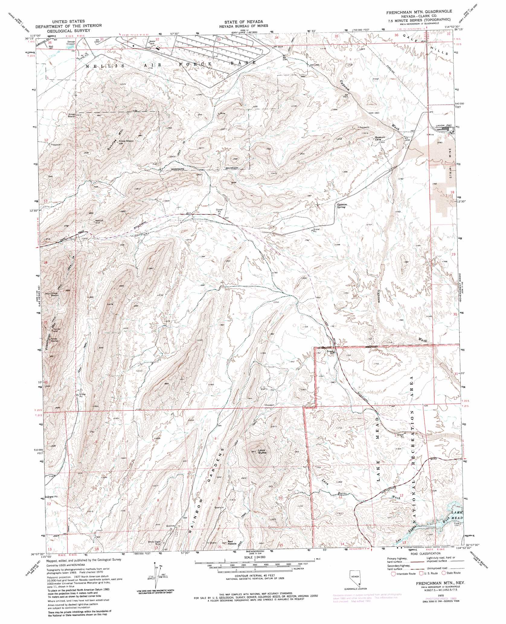
USGS Topo Quad 36114b8 - 1:24,000 scale
| Topo Map Name: | Frenchman Mountain |
| USGS Topo Quad ID: | 36114b8 |
| Print Size: | ca. 21 1/4" wide x 27" high |
| Southeast Coordinates: | 36.125° N latitude / 114.875° W longitude |
| Map Center Coordinates: | 36.1875° N latitude / 114.9375° W longitude |
| U.S. State: | NV |
| Filename: | o36114b8.jpg |
| Download Map JPG Image: | Frenchman Mountain topo map 1:24,000 scale |
| Map Type: | Topographic |
| Topo Series: | 7.5´ |
| Map Scale: | 1:24,000 |
| Source of Map Images: | United States Geological Survey (USGS) |
| Alternate Map Versions: |
Frenchman Mtn. NV 1970, updated 1972 Download PDF Buy paper map Frenchman Mtn. NV 1970, updated 1983 Download PDF Buy paper map Frenchman Mountain NV 2012 Download PDF Buy paper map Frenchman Mountain NV 2014 Download PDF Buy paper map |
1:24,000 Topo Quads surrounding Frenchman Mountain
Gass Peak |
Gass Peak Ne |
Dry Lake Nw |
Dry Lake |
Piute Point |
Gass Peak Sw |
Valley |
Apex |
Dry Lake Se |
Muddy Peak |
Las Vegas Nw |
Las Vegas Ne |
Frenchman Mountain |
Government Wash |
Callville Bay |
Las Vegas Sw |
Las Vegas Se |
Henderson |
Boulder Beach |
Hoover Dam |
Sloan |
Sloan Ne |
Boulder City Nw |
Boulder City |
Ringbolt Rapids |
> Back to 36114a1 at 1:100,000 scale
> Back to 36114a1 at 1:250,000 scale
> Back to U.S. Topo Maps home
Frenchman Mountain topo map: Gazetteer
Frenchman Mountain: Mines
Gypsum Cave Mine elevation 560m 1837′Schumaker Gypsum Mine elevation 552m 1811′
White Eagle Mine elevation 589m 1932′
Frenchman Mountain: Parks
Sunrise Mountain Natural Area elevation 868m 2847′Frenchman Mountain: Pillars
Red Needle elevation 568m 1863′Frenchman Mountain: Ranges
Frenchman Range elevation 792m 2598′Frenchman Mountain: Ridges
Rainbow Gardens elevation 635m 2083′Frenchman Mountain: Springs
Gypsum Spring elevation 535m 1755′Frenchman Mountain: Streams
Las Vegas Wash elevation 367m 1204′Lava Butte Wash elevation 374m 1227′
Frenchman Mountain: Summits
Frenchman Mountain elevation 1205m 3953′Lava Butte elevation 863m 2831′
Sunrise Mountain elevation 1010m 3313′
Frenchman Mountain digital topo map on disk
Buy this Frenchman Mountain topo map showing relief, roads, GPS coordinates and other geographical features, as a high-resolution digital map file on DVD:
Southern Sierra Nevada, California & Southern Nevada
Buy digital topo maps: Southern Sierra Nevada, California & Southern Nevada