Valley Of Fire East Topo Map Nevada
To zoom in, hover over the map of Valley Of Fire East
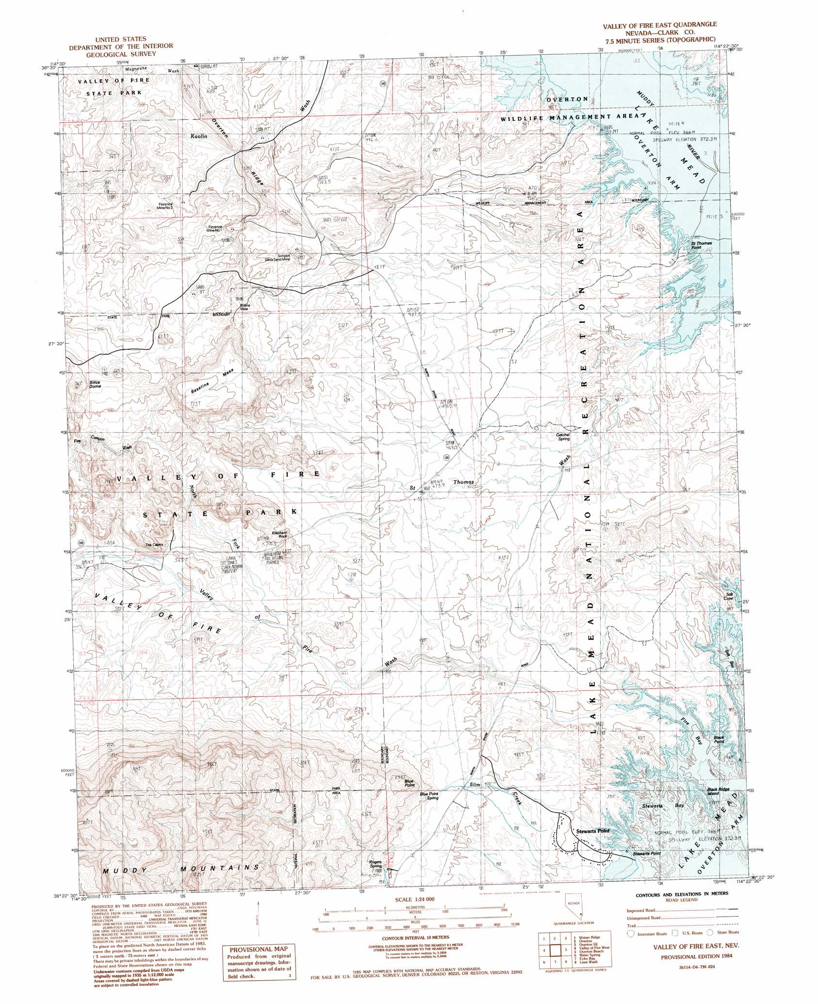
USGS Topo Quad 36114d4 - 1:24,000 scale
| Topo Map Name: | Valley Of Fire East |
| USGS Topo Quad ID: | 36114d4 |
| Print Size: | ca. 21 1/4" wide x 27" high |
| Southeast Coordinates: | 36.375° N latitude / 114.375° W longitude |
| Map Center Coordinates: | 36.4375° N latitude / 114.4375° W longitude |
| U.S. State: | NV |
| Filename: | o36114d4.jpg |
| Download Map JPG Image: | Valley Of Fire East topo map 1:24,000 scale |
| Map Type: | Topographic |
| Topo Series: | 7.5´ |
| Map Scale: | 1:24,000 |
| Source of Map Images: | United States Geological Survey (USGS) |
| Alternate Map Versions: |
Valley of Fire East NV 1984, updated 1984 Download PDF Buy paper map Valley of Fire East NV 1984, updated 1984 Download PDF Buy paper map Valley of Fire East NV 2012 Download PDF Buy paper map Valley of Fire East NV 2014 Download PDF Buy paper map |
1:24,000 Topo Quads surrounding Valley Of Fire East
Moapa West |
Moapa East |
Overton Nw |
Overton Ne |
Riverside |
Ute |
Weiser Ridge |
Overton |
Overton Se |
Whitney Pocket |
Piute Point |
Valley Of Fire West |
Valley Of Fire East |
Overton Beach |
Devils Throat |
Muddy Peak |
Bitter Spring |
Echo Bay |
Lime Wash |
Gold Butte |
Callville Bay |
Boulder Canyon |
Middle Point |
Garrett Butte |
Jumbo Peak |
> Back to 36114a1 at 1:100,000 scale
> Back to 36114a1 at 1:250,000 scale
> Back to U.S. Topo Maps home
Valley Of Fire East topo map: Gazetteer
Valley Of Fire East: Arroyos
Fire Canyon Wash elevation 542m 1778′Valley Of Fire East: Bays
Fire Bay elevation 367m 1204′Salt Bay elevation 367m 1204′
Stewarts Bay elevation 367m 1204′
Valley Of Fire East: Capes
Black Point elevation 367m 1204′Saint Thomas Point elevation 381m 1250′
Stewarts Point elevation 377m 1236′
Valley Of Fire East: Islands
Black Ridge Island elevation 380m 1246′Valley Of Fire East: Mines
Florence Mine Number One elevation 495m 1624′Florence Mine Number Two elevation 478m 1568′
Simplot Silica Sand Mine elevation 499m 1637′
Valley Of Fire East: Parks
Arrowhead Trail Historic Marker elevation 535m 1755′Buena Vista Recreation Area elevation 576m 1889′
Captain John J Clark Memorial Monument elevation 510m 1673′
Overton Wildlife Management Area elevation 369m 1210′
Valley Of Fire East: Populated Places
Lost City (historical) elevation 367m 1204′Stewarts Point elevation 390m 1279′
Valley Of Fire East: Ridges
Overton Ridge elevation 493m 1617′Valley Of Fire East: Springs
Blue Point Spring elevation 470m 1541′Getchel Spring elevation 421m 1381′
Rogers Spring elevation 487m 1597′
Valley Of Fire East: Streams
North Fork Valley of Fire Wash elevation 498m 1633′Saint Thomas Wash elevation 380m 1246′
Slim Creek elevation 413m 1354′
Valley of Fire Wash elevation 369m 1210′
Valley Of Fire East: Summits
Baseline Mesa elevation 720m 2362′Blue Point elevation 639m 2096′
Dugway Hill (historical) elevation 380m 1246′
Elephant Rock elevation 566m 1856′
Silica Dome elevation 681m 2234′
Valley Of Fire East: Valleys
Salt Ravine elevation 367m 1204′Valley of Fire elevation 369m 1210′
Valley Of Fire East digital topo map on disk
Buy this Valley Of Fire East topo map showing relief, roads, GPS coordinates and other geographical features, as a high-resolution digital map file on DVD:
Southern Sierra Nevada, California & Southern Nevada
Buy digital topo maps: Southern Sierra Nevada, California & Southern Nevada