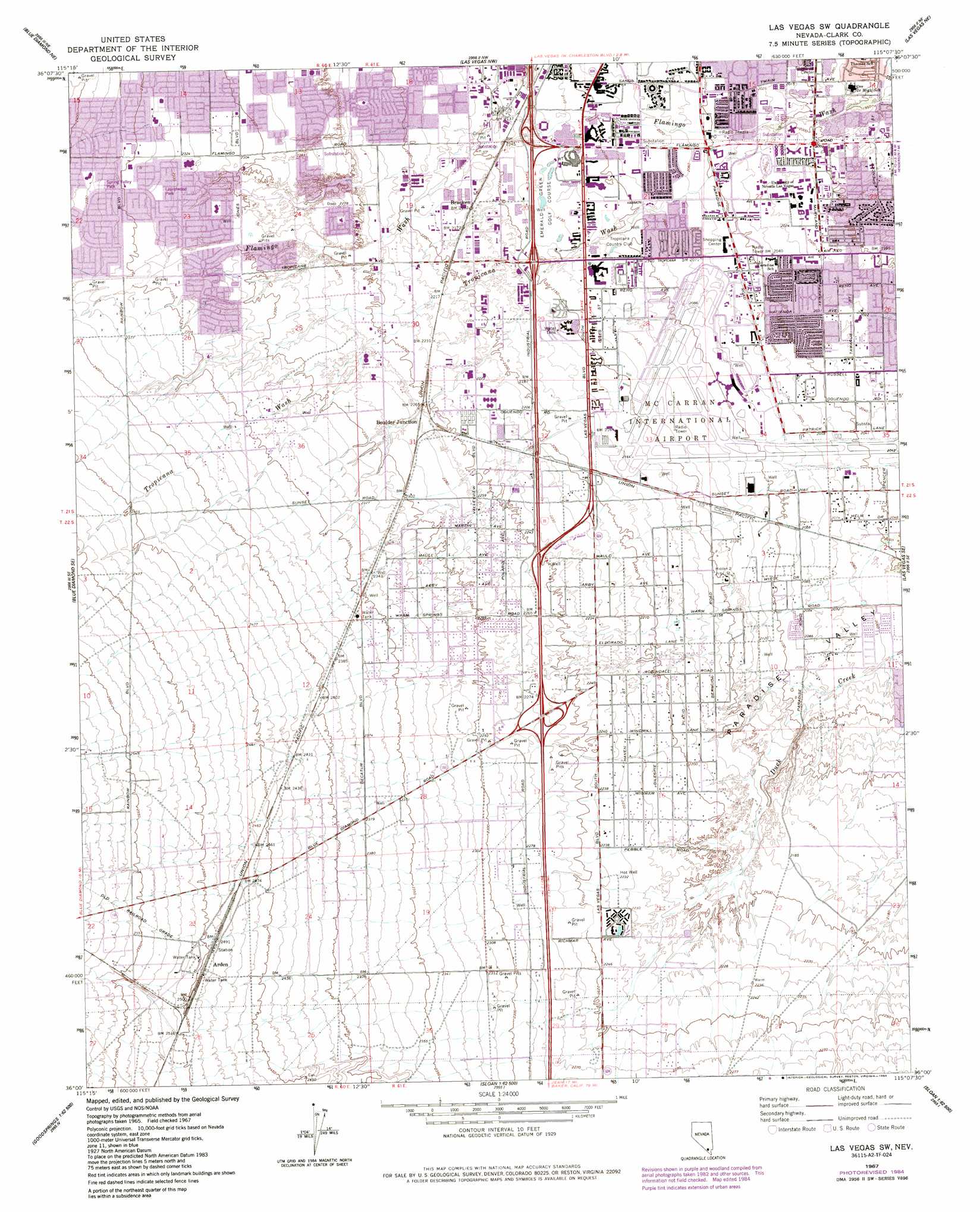
Las Vegas Sw Topo Map Nevada
To zoom in, hover over the map of Las Vegas Sw
USGS Topo Quad 36115a2 - 1:24,000 scale
| Topo Map Name: | Las Vegas Sw |
| USGS Topo Quad ID: | 36115a2 |
| Print Size: | ca. 21 1/4" wide x 27" high |
| Southeast Coordinates: | 36° N latitude / 115.125° W longitude |
| Map Center Coordinates: | 36.0625° N latitude / 115.1875° W longitude |
| U.S. State: | NV |
| Filename: | o36115a2.jpg |
| Download Map JPG Image: | Las Vegas Sw topo map 1:24,000 scale |
| Map Type: | Topographic |
| Topo Series: | 7.5´ |
| Map Scale: | 1:24,000 |
| Source of Map Images: | United States Geological Survey (USGS) |
| Alternate Map Versions: |
Las Vegas SW NV 1967, updated 1968 Download PDF Buy paper map Las Vegas SW NV 1967, updated 1977 Download PDF Buy paper map Las Vegas SW NV 1967, updated 1984 Download PDF Buy paper map Las Vegas SW NV 1967, updated 1984 Download PDF Buy paper map Las Vegas SW NV 1967, updated 1984 Download PDF Buy paper map Las Vegas SW NV 1973, updated 1977 Download PDF Buy paper map Las Vegas SW NV 2012 Download PDF Buy paper map Las Vegas SW NV 2014 Download PDF Buy paper map |
1:24,000 Topo Quads surrounding Las Vegas Sw
Grapevine Spring |
Tule Springs Park |
Gass Peak Sw |
Valley |
Apex |
La Madre Mountain |
Blue Diamond Ne |
Las Vegas Nw |
Las Vegas Ne |
Frenchman Mountain |
Blue Diamond |
Blue Diamond Se |
Las Vegas Sw |
Las Vegas Se |
Henderson |
Cottonwood Pass |
Bird Spring |
Sloan |
Sloan Ne |
Boulder City Nw |
Goodsprings |
Jean |
Hidden Valley |
Sloan Se |
Boulder City Sw |
> Back to 36115a1 at 1:100,000 scale
> Back to 36114a1 at 1:250,000 scale
> Back to U.S. Topo Maps home
Las Vegas Sw topo map: Gazetteer
Las Vegas Sw: Airports
Claude I Howard Heliport elevation 664m 2178′Hacienda Hotel Heliport elevation 656m 2152′
McCarran International Airport elevation 645m 2116′
Las Vegas Sw: Crossings
Interchange 33 elevation 693m 2273′Interchange 34 elevation 688m 2257′
Interchange 36 elevation 666m 2185′
Interchange 37 elevation 659m 2162′
Interchange 38 elevation 650m 2132′
Las Vegas Sw: Parks
Bill Wildcat Morris Rebel Park elevation 622m 2040′Desert Bloom Park elevation 656m 2152′
Durango School Park elevation 730m 2395′
Earl E Wilson Baseball Stadium elevation 623m 2043′
Eller Media Softball Stadium elevation 624m 2047′
Guinn School Park elevation 708m 2322′
Hidden Palms Park elevation 664m 2178′
Laurelwood Park elevation 713m 2339′
Myron Partridge Track Stadium elevation 623m 2043′
Orr School Park elevation 599m 1965′
Paradise Vista Park elevation 616m 2020′
Peter Johann Soccer Field elevation 621m 2037′
Prosperity Park elevation 729m 2391′
Spring Valley Park elevation 723m 2372′
West Flamingo Park elevation 705m 2312′
Las Vegas Sw: Populated Places
Arden elevation 760m 2493′Boulder Junction elevation 695m 2280′
Bracken elevation 665m 2181′
Enterprise elevation 778m 2552′
Mountain's Edge elevation 779m 2555′
Paradise elevation 627m 2057′
Spring Valley elevation 721m 2365′
Las Vegas Sw: Post Offices
Airport Branch Post Office elevation 639m 2096′Arden Post Office (historical) elevation 760m 2493′
Emerald Post Office elevation 704m 2309′
Paradise Valley Branch Post Office elevation 625m 2050′
Silverado Station Post Office elevation 669m 2194′
Las Vegas Sw: Springs
Group Springs elevation 635m 2083′Las Vegas Sw: Streams
Tropicana Wash elevation 610m 2001′Las Vegas Sw: Wells
Evey Well elevation 659m 2162′Las Vegas Sw digital topo map on disk
Buy this Las Vegas Sw topo map showing relief, roads, GPS coordinates and other geographical features, as a high-resolution digital map file on DVD:
Southern Sierra Nevada, California & Southern Nevada
Buy digital topo maps: Southern Sierra Nevada, California & Southern Nevada