Blue Diamond Topo Map Nevada
To zoom in, hover over the map of Blue Diamond
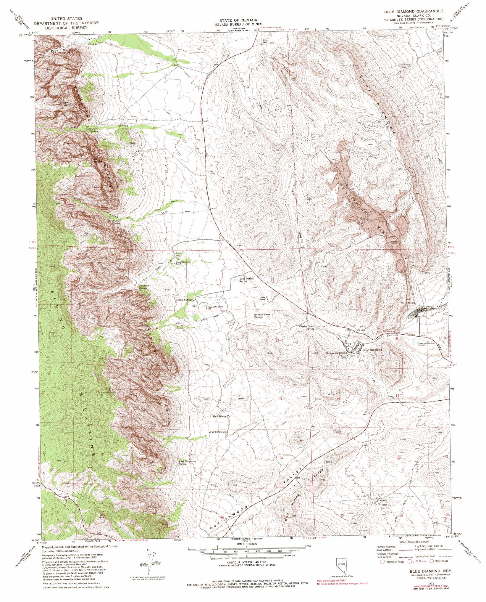
USGS Topo Quad 36115a4 - 1:24,000 scale
| Topo Map Name: | Blue Diamond |
| USGS Topo Quad ID: | 36115a4 |
| Print Size: | ca. 21 1/4" wide x 27" high |
| Southeast Coordinates: | 36° N latitude / 115.375° W longitude |
| Map Center Coordinates: | 36.0625° N latitude / 115.4375° W longitude |
| U.S. State: | NV |
| Filename: | o36115a4.jpg |
| Download Map JPG Image: | Blue Diamond topo map 1:24,000 scale |
| Map Type: | Topographic |
| Topo Series: | 7.5´ |
| Map Scale: | 1:24,000 |
| Source of Map Images: | United States Geological Survey (USGS) |
| Alternate Map Versions: |
Blue Diamond NV 1972, updated 1974 Download PDF Buy paper map Blue Diamond NV 1972, updated 1984 Download PDF Buy paper map Blue Diamond NV 2012 Download PDF Buy paper map Blue Diamond NV 2015 Download PDF Buy paper map |
| FStopo: | US Forest Service topo Blue Diamond is available: Download FStopo PDF Download FStopo TIF |
1:24,000 Topo Quads surrounding Blue Diamond
Charleston Peak |
Angel Peak |
Grapevine Spring |
Tule Springs Park |
Gass Peak Sw |
Griffith Peak |
La Madre Spring |
La Madre Mountain |
Blue Diamond Ne |
Las Vegas Nw |
Lost Cabin Spring |
Mountain Springs |
Blue Diamond |
Blue Diamond Se |
Las Vegas Sw |
Green Monster Mine |
Potosi |
Cottonwood Pass |
Bird Spring |
Sloan |
West Of Shenandoah Peak |
Shenandoah Peak |
Goodsprings |
Jean |
Hidden Valley |
> Back to 36115a1 at 1:100,000 scale
> Back to 36114a1 at 1:250,000 scale
> Back to U.S. Topo Maps home
Blue Diamond topo map: Gazetteer
Blue Diamond: Mines
Blue Diamond Mine elevation 1327m 4353′Blue Diamond: Parks
Blue Diamond Park elevation 1029m 3375′Red Rock Canyon National Conservation Area elevation 1200m 3937′
Spring Mountain Ranch State Park elevation 1136m 3727′
Blue Diamond: Populated Places
Blue Diamond elevation 1031m 3382′Bonnie Springs elevation 1127m 3697′
Blue Diamond: Post Offices
Blue Diamond Post Office elevation 1031m 3382′Old Nevada Village Rural Station Post Office elevation 1145m 3756′
Blue Diamond: Reservoirs
Crystal Tank elevation 1578m 5177′Rose Tank (historical) elevation 1238m 4061′
White Rock Reservoir elevation 1221m 4005′
Blue Diamond: Springs
Cottonwood Spring elevation 1040m 3412′First Creek Spring elevation 1239m 4064′
Lone Grapevine Spring elevation 1275m 4183′
Lone Willow Spring elevation 1086m 3562′
Moonshine Spring elevation 1329m 4360′
Mormon Green Springs elevation 1083m 3553′
Mud Spring Number One elevation 1172m 3845′
Mud Spring Number Two elevation 1158m 3799′
Oak Creek Spring elevation 1261m 4137′
Pine Creek Spring elevation 1289m 4229′
Point Spring elevation 1146m 3759′
Sandstone Spring elevation 1220m 4002′
Shovel Spring elevation 1234m 4048′
Wheeler Camp Spring elevation 1051m 3448′
Blue Diamond: Streams
First Creek elevation 1225m 4019′Oak Creek elevation 1191m 3907′
Pine Creek elevation 1191m 3907′
Blue Diamond: Summits
Blue Diamond Hill elevation 1503m 4931′Mount Wilson elevation 2121m 6958′
Rainbow Mountain elevation 2075m 6807′
Blue Diamond: Valleys
Cottonwood Valley elevation 1068m 3503′Sandstone Canyon elevation 1224m 4015′
Blue Diamond digital topo map on disk
Buy this Blue Diamond topo map showing relief, roads, GPS coordinates and other geographical features, as a high-resolution digital map file on DVD:
Southern Sierra Nevada, California & Southern Nevada
Buy digital topo maps: Southern Sierra Nevada, California & Southern Nevada