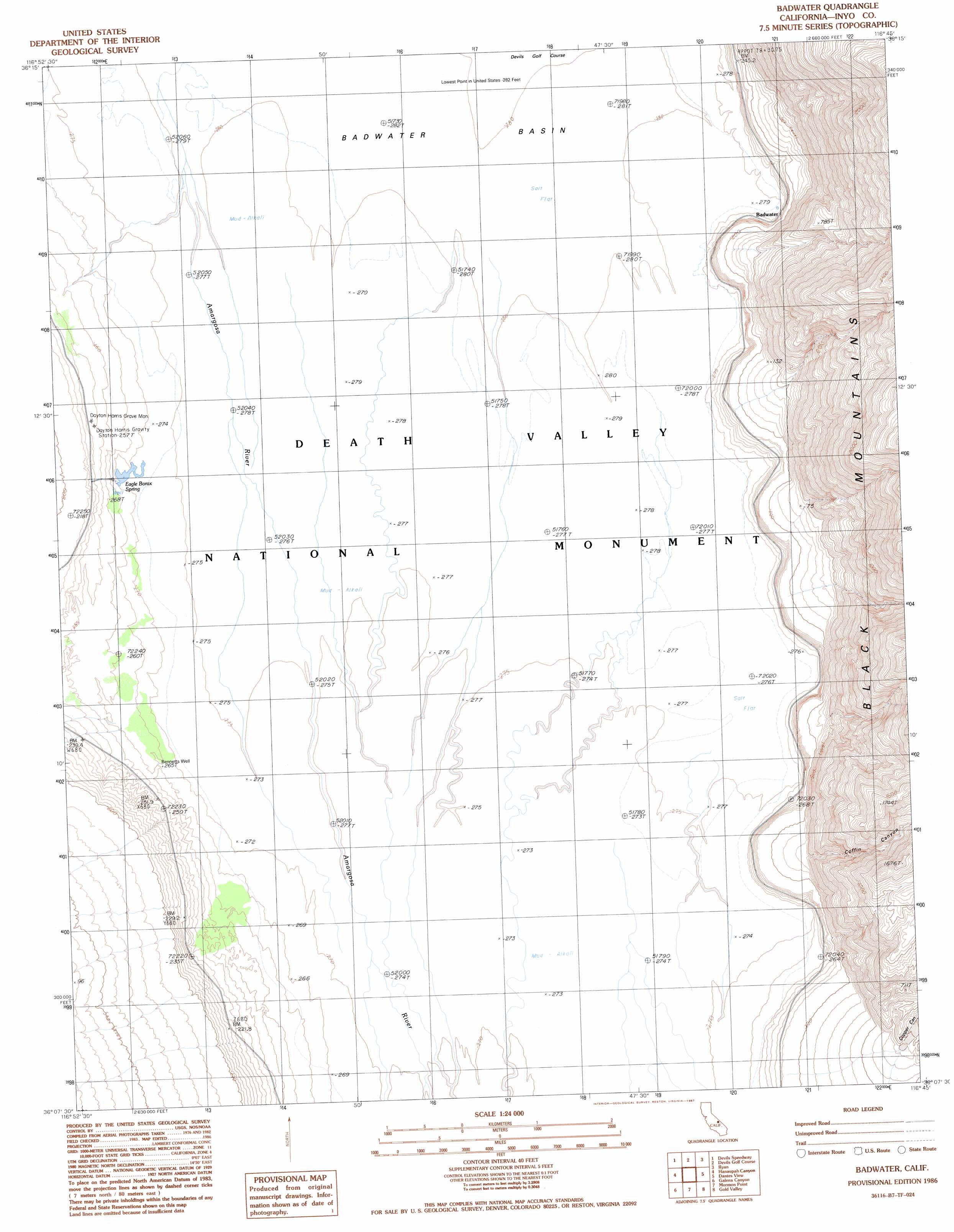
Badwater Topo Map California
To zoom in, hover over the map of Badwater
USGS Topo Quad 36116b7 - 1:24,000 scale
| Topo Map Name: | Badwater |
| USGS Topo Quad ID: | 36116b7 |
| Print Size: | ca. 21 1/4" wide x 27" high |
| Southeast Coordinates: | 36.125° N latitude / 116.75° W longitude |
| Map Center Coordinates: | 36.1875° N latitude / 116.8125° W longitude |
| U.S. State: | CA |
| Filename: | o36116b7.jpg |
| Download Map JPG Image: | Badwater topo map 1:24,000 scale |
| Map Type: | Topographic |
| Topo Series: | 7.5´ |
| Map Scale: | 1:24,000 |
| Source of Map Images: | United States Geological Survey (USGS) |
| Alternate Map Versions: |
Badwater CA 1986, updated 1987 Download PDF Buy paper map Badwater CA 1986, updated 1987 Download PDF Buy paper map Badwater CA 2012 Download PDF Buy paper map Badwater CA 2015 Download PDF Buy paper map |
1:24,000 Topo Quads surrounding Badwater
Tucki Wash |
East Of Furnace Creek |
Furnace Creek |
Echo Canyon |
East Of Echo Canyon |
Wildrose Peak |
Devils Speedway |
Devils Golf Course |
Ryan |
East Of Ryan |
Telescope Peak |
Hanaupah Canyon |
Badwater |
Dantes View |
Greenwater Canyon |
Panamint |
Galena Canyon |
Mormon Point |
Gold Valley |
Funeral Peak |
Manly Peak |
Anvil Spring Canyon West |
Anvil Spring Canyon East |
Shore Line Butte |
Epaulet Peak |
> Back to 36116a1 at 1:100,000 scale
> Back to 36116a1 at 1:250,000 scale
> Back to U.S. Topo Maps home
Badwater topo map: Gazetteer
Badwater: Basins
Death Valley elevation -85m -279′Badwater: Populated Places
Badwater elevation -81m -266′Badwater: Springs
Eagle Borax Spring elevation -82m -270′Badwater: Streams
Amargosa River elevation -85m -279′Badwater: Valleys
Coffin Canyon elevation -15m -50′Copper Canyon elevation 38m 124′
Badwater: Wells
Bennetts Well elevation -81m -266′Badwater digital topo map on disk
Buy this Badwater topo map showing relief, roads, GPS coordinates and other geographical features, as a high-resolution digital map file on DVD:
Southern Sierra Nevada, California & Southern Nevada
Buy digital topo maps: Southern Sierra Nevada, California & Southern Nevada