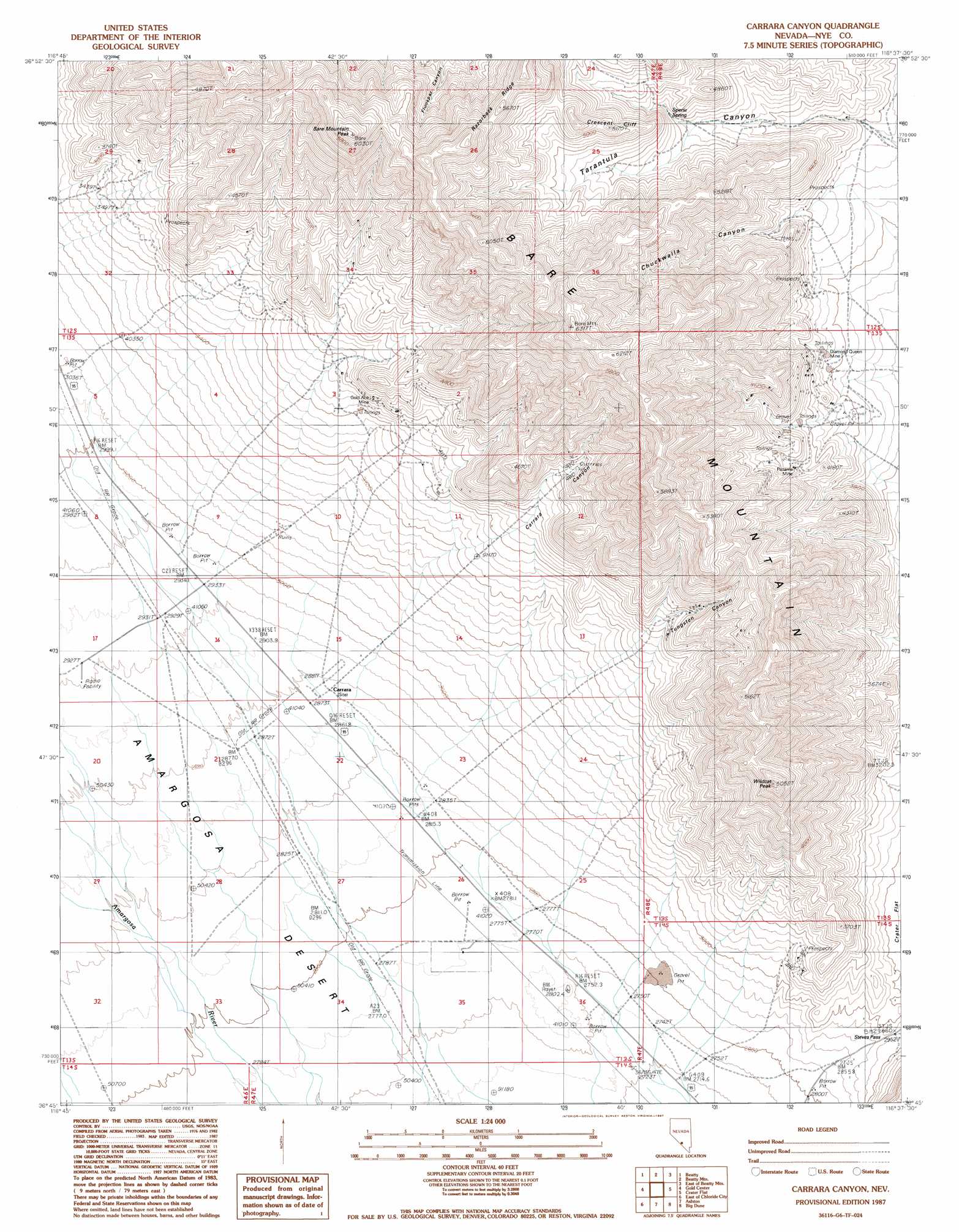
Carrara Canyon Topo Map Nevada
To zoom in, hover over the map of Carrara Canyon
USGS Topo Quad 36116g6 - 1:24,000 scale
| Topo Map Name: | Carrara Canyon |
| USGS Topo Quad ID: | 36116g6 |
| Print Size: | ca. 21 1/4" wide x 27" high |
| Southeast Coordinates: | 36.75° N latitude / 116.625° W longitude |
| Map Center Coordinates: | 36.8125° N latitude / 116.6875° W longitude |
| U.S. State: | NV |
| Filename: | o36116g6.jpg |
| Download Map JPG Image: | Carrara Canyon topo map 1:24,000 scale |
| Map Type: | Topographic |
| Topo Series: | 7.5´ |
| Map Scale: | 1:24,000 |
| Source of Map Images: | United States Geological Survey (USGS) |
| Alternate Map Versions: |
Carrara Canyon NV 1987, updated 1987 Download PDF Buy paper map Carrara Canyon NV 2012 Download PDF Buy paper map Carrara Canyon NV 2014 Download PDF Buy paper map |
1:24,000 Topo Quads surrounding Carrara Canyon
Springdale Sw |
Springdale |
Thirsty Canyon Sw |
Thirsty Canyon Se |
Timber Mountain |
Bullfrog Mountain |
Beatty |
Beatty Mountain |
East Of Beatty Mountain |
Topopah Springs Nw |
Daylight Pass |
Gold Center |
Carrara Canyon |
Crater Flat |
Busted Butte |
Chloride City |
East Of Chloride City |
Ashton |
Big Dune |
Lathrop Wells |
Beatty Junction |
Nevares Peak |
Lees Camp |
Leeland |
South Of Amargosa Valley |
> Back to 36116e1 at 1:100,000 scale
> Back to 36116a1 at 1:250,000 scale
> Back to U.S. Topo Maps home
Carrara Canyon topo map: Gazetteer
Carrara Canyon: Cliffs
Crescent Cliff elevation 1590m 5216′Carrara Canyon: Gaps
Steves Pass elevation 903m 2962′Carrara Canyon: Mines
Arista Mine elevation 1147m 3763′Diamond Queen Mine elevation 1164m 3818′
Gold Ace Mine elevation 1123m 3684′
Grand Junction Mine elevation 1338m 4389′
Mexican Mine elevation 968m 3175′
Panama Mine elevation 1259m 4130′
Carrara Canyon: Populated Places
Carrara (historical) elevation 878m 2880′Carrara Canyon: Post Offices
Carrara Post Office (historical) elevation 878m 2880′Carrara Canyon: Ranges
Bare Mountain elevation 1912m 6272′Carrara Canyon: Ridges
Razorback Ridge elevation 1692m 5551′Carrara Canyon: Springs
Specie Spring elevation 1370m 4494′Carrara Canyon: Summits
Bare Mountain Peak elevation 1834m 6017′Black Marble elevation 1107m 3631′
Wildcat Peak elevation 1511m 4957′
Carrara Canyon: Valleys
Carrara Canyon elevation 1077m 3533′Chuckwalla Canyon elevation 1201m 3940′
Tarantula Canyon elevation 1220m 4002′
Tungsten Canyon elevation 1088m 3569′
Carrara Canyon digital topo map on disk
Buy this Carrara Canyon topo map showing relief, roads, GPS coordinates and other geographical features, as a high-resolution digital map file on DVD:
Southern Sierra Nevada, California & Southern Nevada
Buy digital topo maps: Southern Sierra Nevada, California & Southern Nevada