Panamint Topo Map California
To zoom in, hover over the map of Panamint
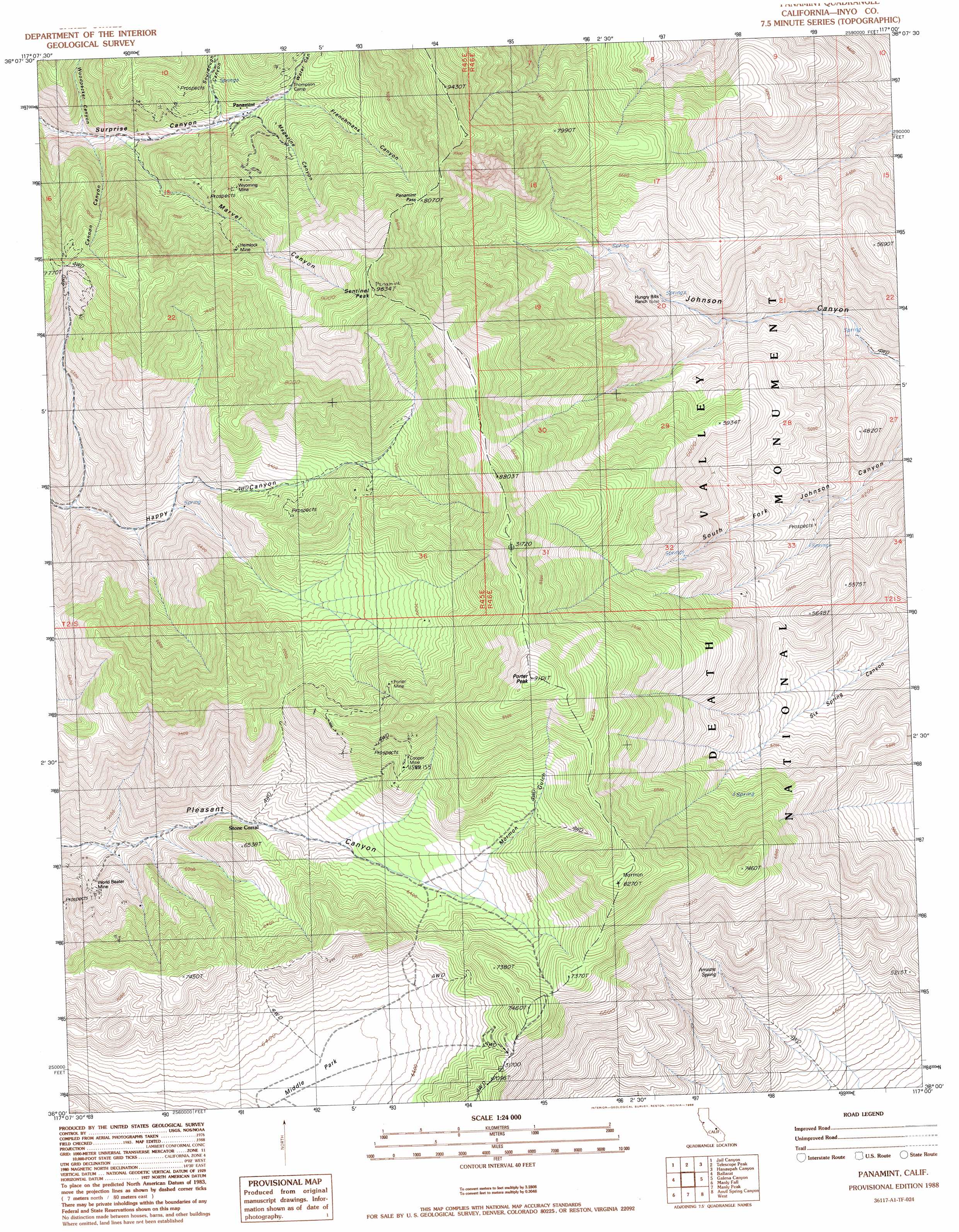
USGS Topo Quad 36117a1 - 1:24,000 scale
| Topo Map Name: | Panamint |
| USGS Topo Quad ID: | 36117a1 |
| Print Size: | ca. 21 1/4" wide x 27" high |
| Southeast Coordinates: | 36° N latitude / 117° W longitude |
| Map Center Coordinates: | 36.0625° N latitude / 117.0625° W longitude |
| U.S. State: | CA |
| Filename: | o36117a1.jpg |
| Download Map JPG Image: | Panamint topo map 1:24,000 scale |
| Map Type: | Topographic |
| Topo Series: | 7.5´ |
| Map Scale: | 1:24,000 |
| Source of Map Images: | United States Geological Survey (USGS) |
| Alternate Map Versions: |
Panamint CA 1988, updated 1988 Download PDF Buy paper map Panamint CA 1988, updated 1988 Download PDF Buy paper map Panamint CA 2012 Download PDF Buy paper map Panamint CA 2015 Download PDF Buy paper map |
1:24,000 Topo Quads surrounding Panamint
Nova Canyon |
Emigrant Pass |
Wildrose Peak |
Devils Speedway |
Devils Golf Course |
Maturango Peak Ne |
Jail Canyon |
Telescope Peak |
Hanaupah Canyon |
Badwater |
Maturango Peak Se |
Ballarat |
Panamint |
Galena Canyon |
Mormon Point |
Slate Range Crossing |
Manly Fall |
Manly Peak |
Anvil Spring Canyon West |
Anvil Spring Canyon East |
Trona East |
Copper Queen Canyon |
Sourdough Spring |
Wingate Wash West |
Wingate Wash East |
> Back to 36117a1 at 1:100,000 scale
> Back to 36116a1 at 1:250,000 scale
> Back to U.S. Topo Maps home
Panamint topo map: Gazetteer
Panamint: Basins
Middle Park elevation 1911m 6269′Panamint: Gaps
Panamint Pass elevation 2471m 8106′Panamint: Mines
Cooper Mine elevation 2211m 7253′Hemlock Mine elevation 2349m 7706′
Hudson River Mine elevation 2503m 8211′
Porter Mine elevation 2339m 7673′
World Beater Mine elevation 1701m 5580′
Wyoming Mine elevation 2304m 7559′
Panamint: Populated Places
Panamint elevation 1921m 6302′Panamint: Post Offices
Panamint Post Office (historical) elevation 1921m 6302′Panamint: Springs
Arrastre Spring elevation 1692m 5551′Panamint: Summits
Porter Peak elevation 2756m 9041′Panamint: Valleys
Cannon Canyon elevation 1701m 5580′Frenchmans Canyon elevation 2008m 6587′
Magazine Canyon elevation 1950m 6397′
Marvel Canyon elevation 1769m 5803′
Mormon Gulch elevation 1946m 6384′
Sourdough Canyon elevation 1901m 6236′
Water Canyon elevation 2038m 6686′
Woodpecker Canyon elevation 1698m 5570′
Panamint digital topo map on disk
Buy this Panamint topo map showing relief, roads, GPS coordinates and other geographical features, as a high-resolution digital map file on DVD:
Southern Sierra Nevada, California & Southern Nevada
Buy digital topo maps: Southern Sierra Nevada, California & Southern Nevada