China Gardens Topo Map California
To zoom in, hover over the map of China Gardens
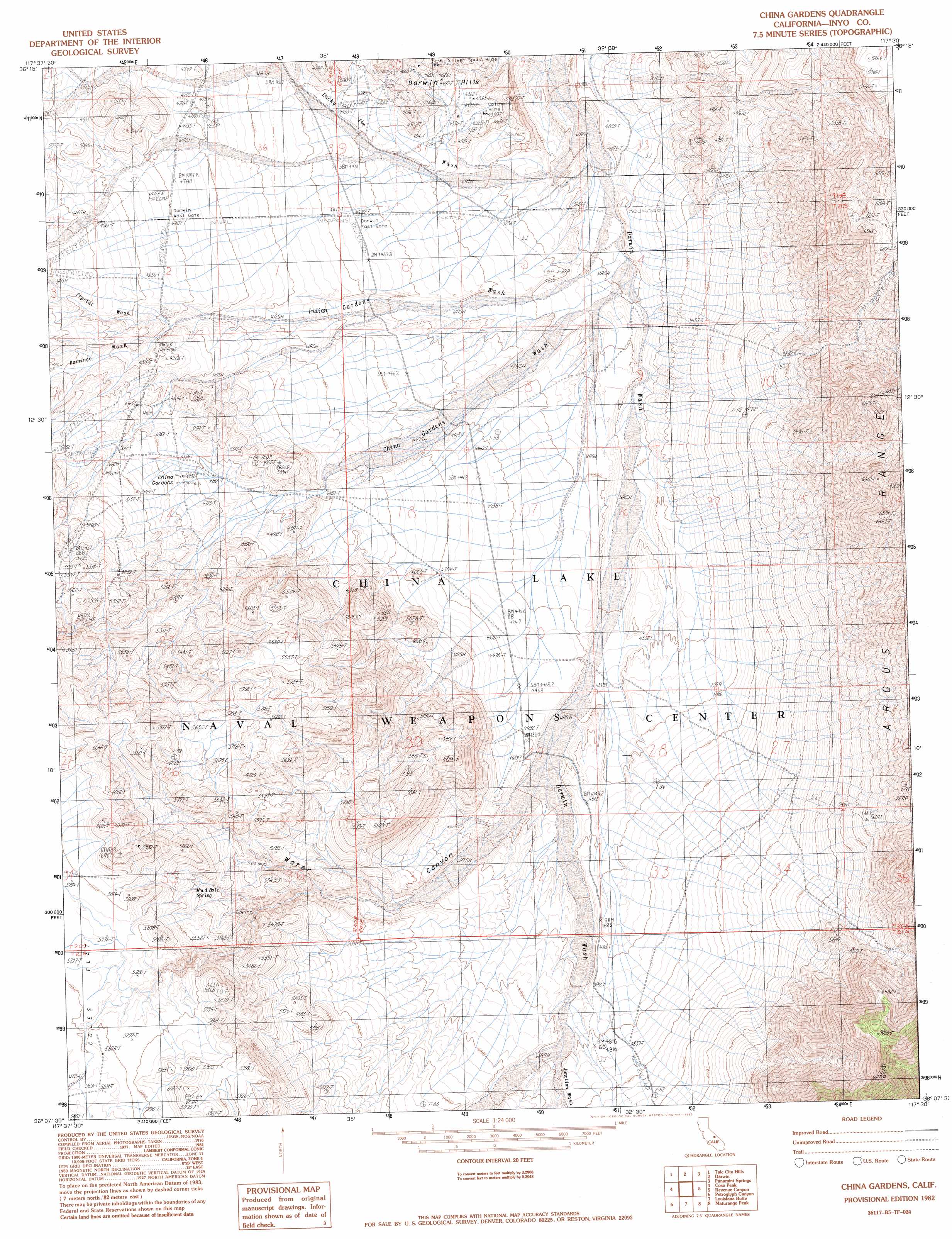
USGS Topo Quad 36117b5 - 1:24,000 scale
| Topo Map Name: | China Gardens |
| USGS Topo Quad ID: | 36117b5 |
| Print Size: | ca. 21 1/4" wide x 27" high |
| Southeast Coordinates: | 36.125° N latitude / 117.5° W longitude |
| Map Center Coordinates: | 36.1875° N latitude / 117.5625° W longitude |
| U.S. State: | CA |
| Filename: | o36117b5.jpg |
| Download Map JPG Image: | China Gardens topo map 1:24,000 scale |
| Map Type: | Topographic |
| Topo Series: | 7.5´ |
| Map Scale: | 1:24,000 |
| Source of Map Images: | United States Geological Survey (USGS) |
| Alternate Map Versions: |
China Gardens CA 1982, updated 1983 Download PDF Buy paper map China Gardens Spring CA 2012 Download PDF Buy paper map China Gardens Spring CA 2015 Download PDF Buy paper map |
1:24,000 Topo Quads surrounding China Gardens
Keeler |
Santa Rosa Flat |
Lee Wash |
The Dunes |
Panamint Butte |
Centennial Canyon |
Talc City Hills |
Darwin |
Panamint Springs |
Nova Canyon |
Upper Centennial Flat |
Coso Peak |
China Gardens |
Revenue Canyon |
Maturango Peak Ne |
Cactus Peak |
Petroglyph Canyon |
Louisiana Butte |
Maturango Peak |
Maturango Peak Se |
Volcano Peak |
Airport Lake |
Mountain Springs Canyon |
Homewood Canyon |
Slate Range Crossing |
> Back to 36117a1 at 1:100,000 scale
> Back to 36116a1 at 1:250,000 scale
> Back to U.S. Topo Maps home
China Gardens topo map: Gazetteer
China Gardens: Mines
Columbia Mine elevation 1326m 4350′Silverspoon Mine elevation 1355m 4445′
China Gardens: Springs
China Gardens Spring elevation 1505m 4937′Mud Hole Spring elevation 1675m 5495′
China Gardens: Streams
China Gardens Wash elevation 1246m 4087′Crystal Wash elevation 1454m 4770′
Domingo Wash elevation 1454m 4770′
Indian Gardens Wash elevation 1225m 4019′
Junction Wash elevation 1457m 4780′
Lucky Jim Wash elevation 1209m 3966′
China Gardens: Valleys
Mill Canyon elevation 1269m 4163′Water Canyon elevation 1355m 4445′
China Gardens digital topo map on disk
Buy this China Gardens topo map showing relief, roads, GPS coordinates and other geographical features, as a high-resolution digital map file on DVD:
Southern Sierra Nevada, California & Southern Nevada
Buy digital topo maps: Southern Sierra Nevada, California & Southern Nevada