Coso Peak Topo Map California
To zoom in, hover over the map of Coso Peak
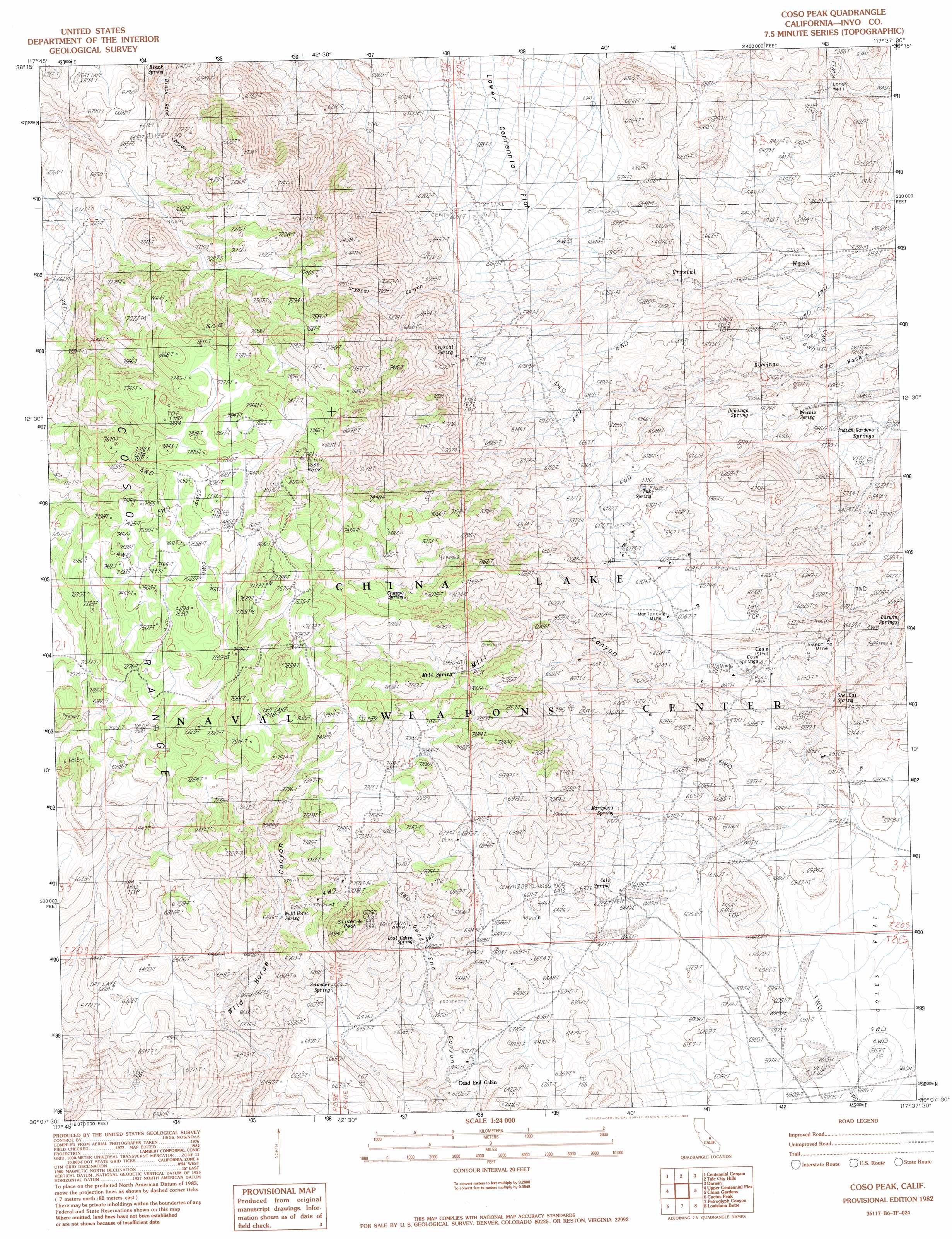
USGS Topo Quad 36117b6 - 1:24,000 scale
| Topo Map Name: | Coso Peak |
| USGS Topo Quad ID: | 36117b6 |
| Print Size: | ca. 21 1/4" wide x 27" high |
| Southeast Coordinates: | 36.125° N latitude / 117.625° W longitude |
| Map Center Coordinates: | 36.1875° N latitude / 117.6875° W longitude |
| U.S. State: | CA |
| Filename: | o36117b6.jpg |
| Download Map JPG Image: | Coso Peak topo map 1:24,000 scale |
| Map Type: | Topographic |
| Topo Series: | 7.5´ |
| Map Scale: | 1:24,000 |
| Source of Map Images: | United States Geological Survey (USGS) |
| Alternate Map Versions: |
Coso Peak CA 1982, updated 1983 Download PDF Buy paper map Coso Peak CA 2012 Download PDF Buy paper map Coso Peak CA 2015 Download PDF Buy paper map |
1:24,000 Topo Quads surrounding Coso Peak
Owens Lake |
Keeler |
Santa Rosa Flat |
Lee Wash |
The Dunes |
Vermillion Canyon |
Centennial Canyon |
Talc City Hills |
Darwin |
Panamint Springs |
Haiwee Reservoirs |
Upper Centennial Flat |
Coso Peak |
China Gardens |
Revenue Canyon |
Coso Junction |
Cactus Peak |
Petroglyph Canyon |
Louisiana Butte |
Maturango Peak |
Little Lake |
Volcano Peak |
Airport Lake |
Mountain Springs Canyon |
Homewood Canyon |
> Back to 36117a1 at 1:100,000 scale
> Back to 36116a1 at 1:250,000 scale
> Back to U.S. Topo Maps home
Coso Peak topo map: Gazetteer
Coso Peak: Flats
Coles Flat elevation 1774m 5820′Coso Peak: Mines
Josephine Mine elevation 1760m 5774′Mariposa Mine elevation 1848m 6062′
Coso Peak: Ranges
Coso Range elevation 2038m 6686′Coso Peak: Springs
Black Spring elevation 1862m 6108′Chappo Spring elevation 2147m 7043′
Cole Spring elevation 1913m 6276′
Coso Springs elevation 1623m 5324′
Crystal Spring elevation 1938m 6358′
Domingo Spring elevation 1694m 5557′
Indian Gardens Spring elevation 1597m 5239′
Lost Cabin Spring elevation 1981m 6499′
Mariposa Spring elevation 1929m 6328′
Mill Spring elevation 2087m 6847′
She Cat Spring elevation 1687m 5534′
Summer Spring elevation 2010m 6594′
Tub Spring elevation 1822m 5977′
Wild Horse Spring elevation 1990m 6528′
Wrinkle Spring elevation 1640m 5380′
Coso Peak: Summits
Coso Peak elevation 2483m 8146′Silver Peak elevation 2287m 7503′
Coso Peak: Valleys
Crystal Canyon elevation 1821m 5974′Coso Peak: Wells
Langs Well elevation 1579m 5180′Coso Peak digital topo map on disk
Buy this Coso Peak topo map showing relief, roads, GPS coordinates and other geographical features, as a high-resolution digital map file on DVD:
Southern Sierra Nevada, California & Southern Nevada
Buy digital topo maps: Southern Sierra Nevada, California & Southern Nevada