Sentinel Peak Topo Map California
To zoom in, hover over the map of Sentinel Peak
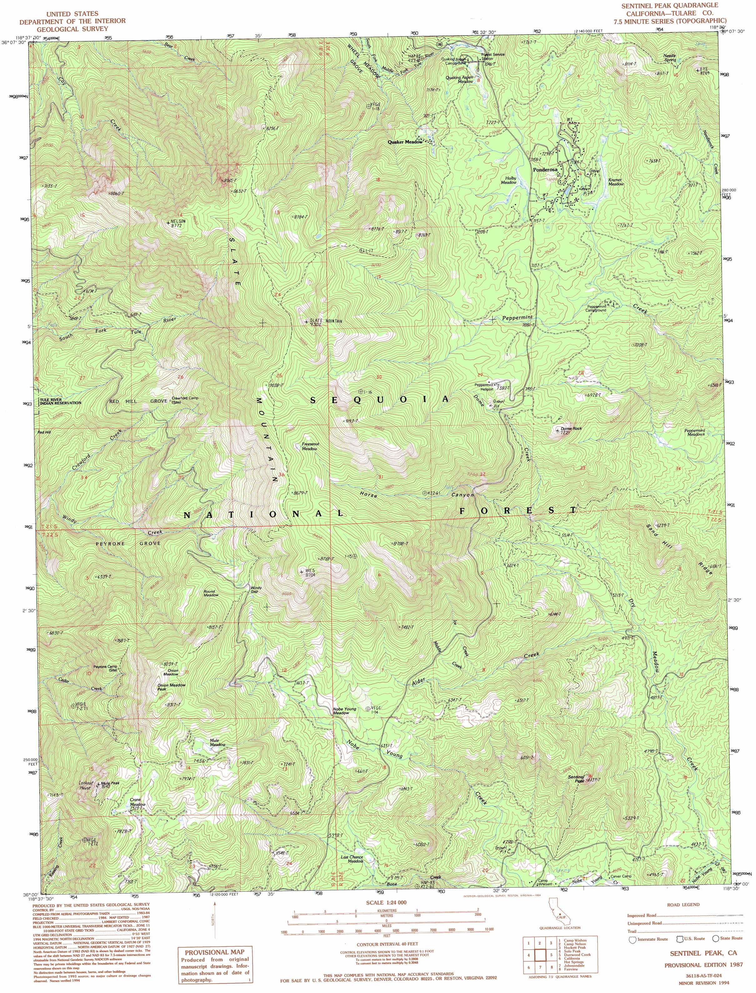
USGS Topo Quad 36118a5 - 1:24,000 scale
| Topo Map Name: | Sentinel Peak |
| USGS Topo Quad ID: | 36118a5 |
| Print Size: | ca. 21 1/4" wide x 27" high |
| Southeast Coordinates: | 36° N latitude / 118.5° W longitude |
| Map Center Coordinates: | 36.0625° N latitude / 118.5625° W longitude |
| U.S. State: | CA |
| Filename: | o36118a5.jpg |
| Download Map JPG Image: | Sentinel Peak topo map 1:24,000 scale |
| Map Type: | Topographic |
| Topo Series: | 7.5´ |
| Map Scale: | 1:24,000 |
| Source of Map Images: | United States Geological Survey (USGS) |
| Alternate Map Versions: |
Sentinel Peak CA 1987, updated 1987 Download PDF Buy paper map Sentinel Peak CA 1987, updated 1994 Download PDF Buy paper map Sentinel Peak CA 2012 Download PDF Buy paper map Sentinel Peak CA 2015 Download PDF Buy paper map |
| FStopo: | US Forest Service topo Sentinel Peak is available: Download FStopo PDF Download FStopo TIF |
1:24,000 Topo Quads surrounding Sentinel Peak
Dennison Peak |
Moses Mountain |
Quinn Peak |
Kern Lake |
Kern Peak |
Springville |
Camp Wishon |
Camp Nelson |
Hockett Peak |
Casa Vieja Meadows |
Globe |
Solo Peak |
Sentinel Peak |
Durrwood Creek |
Bonita Meadows |
Gibbon Peak |
California Hot Springs |
Johnsondale |
Fairview |
Sirretta Peak |
White River |
Posey |
Tobias Peak |
Kernville |
Cannell Peak |
> Back to 36118a1 at 1:100,000 scale
> Back to 36118a1 at 1:250,000 scale
> Back to U.S. Topo Maps home
Sentinel Peak topo map: Gazetteer
Sentinel Peak: Flats
Crane Meadow elevation 2307m 7568′Freezeout Meadow elevation 2569m 8428′
Holby Meadow elevation 2179m 7148′
Kramer Meadow elevation 2157m 7076′
Last Chance Meadow elevation 1778m 5833′
Mule Meadow elevation 2261m 7417′
Nobe Young Meadow elevation 1997m 6551′
Onion Meadow elevation 2466m 8090′
Quaking Aspen Meadow elevation 2142m 7027′
Round Meadow elevation 2275m 7463′
Sentinel Peak: Gaps
Windy Gap elevation 2306m 7565′Sentinel Peak: Populated Places
Ponderosa elevation 2191m 7188′Quaker Meadow elevation 2159m 7083′
Sentinel Peak: Ridges
Sand Hill Ridge elevation 1827m 5994′Sentinel Peak: Springs
Needle Spring elevation 2358m 7736′Sentinel Peak: Streams
Alder Creek elevation 1499m 4917′Crawford Creek elevation 1585m 5200′
Dome Creek elevation 1716m 5629′
Ice Creek elevation 1809m 5935′
Middle Creek elevation 1818m 5964′
Nobe Young Creek elevation 1345m 4412′
Sentinel Peak: Summits
Dome Rock elevation 2199m 7214′Mule Peak elevation 2457m 8061′
Onion Meadow Peak elevation 2529m 8297′
Sentinel Peak elevation 1865m 6118′
Slate Mountain elevation 2829m 9281′
Sentinel Peak: Trails
Summit Trail elevation 2302m 7552′Sentinel Peak: Valleys
Horse Canyon elevation 1786m 5859′Sentinel Peak: Woods
Peyrone Grove elevation 1881m 6171′Red Hill Grove elevation 1960m 6430′
Sentinel Peak digital topo map on disk
Buy this Sentinel Peak topo map showing relief, roads, GPS coordinates and other geographical features, as a high-resolution digital map file on DVD:
Southern Sierra Nevada, California & Southern Nevada
Buy digital topo maps: Southern Sierra Nevada, California & Southern Nevada