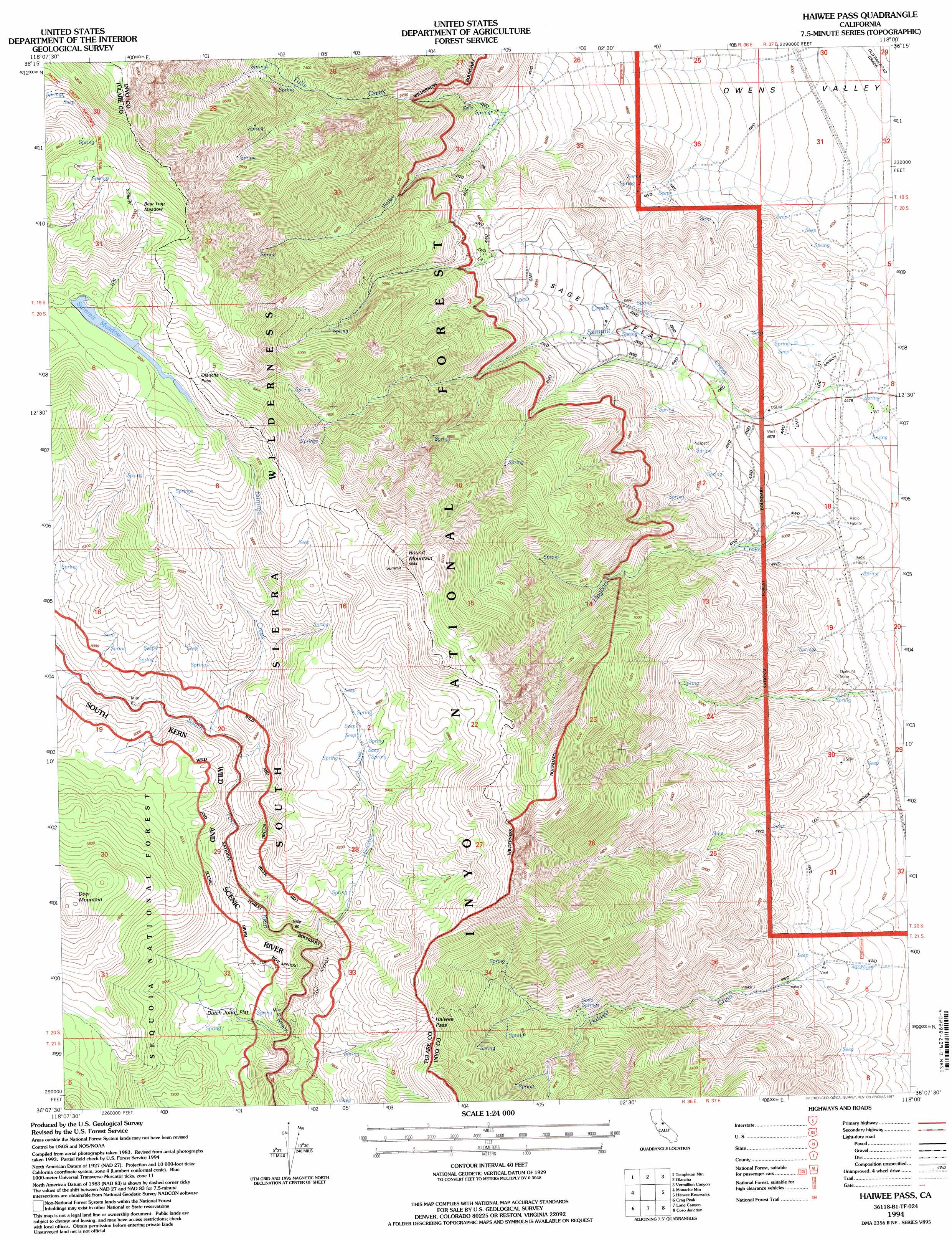
Haiwee Pass Topo Map California
To zoom in, hover over the map of Haiwee Pass
USGS Topo Quad 36118b1 - 1:24,000 scale
| Topo Map Name: | Haiwee Pass |
| USGS Topo Quad ID: | 36118b1 |
| Print Size: | ca. 21 1/4" wide x 27" high |
| Southeast Coordinates: | 36.125° N latitude / 118° W longitude |
| Map Center Coordinates: | 36.1875° N latitude / 118.0625° W longitude |
| U.S. State: | CA |
| Filename: | o36118b1.jpg |
| Download Map JPG Image: | Haiwee Pass topo map 1:24,000 scale |
| Map Type: | Topographic |
| Topo Series: | 7.5´ |
| Map Scale: | 1:24,000 |
| Source of Map Images: | United States Geological Survey (USGS) |
| Alternate Map Versions: |
Haiwee Pass CA 1987, updated 1987 Download PDF Buy paper map Haiwee Pass CA 1987, updated 1994 Download PDF Buy paper map Haiwee Pass CA 1994, updated 1997 Download PDF Buy paper map Haiwee Pass CA 2012 Download PDF Buy paper map Haiwee Pass CA 2015 Download PDF Buy paper map |
| FStopo: | US Forest Service topo Haiwee Pass is available: Download FStopo PDF Download FStopo TIF |
1:24,000 Topo Quads surrounding Haiwee Pass
Johnson Peak |
Cirque Peak |
Bartlett |
Owens Lake |
Keeler |
Kern Peak |
Templeton Mountain |
Olancha |
Vermillion Canyon |
Centennial Canyon |
Casa Vieja Meadows |
Monache Mountain |
Haiwee Pass |
Haiwee Reservoirs |
Upper Centennial Flat |
Bonita Meadows |
Crag Peak |
Long Canyon |
Coso Junction |
Cactus Peak |
Sirretta Peak |
Rockhouse Basin |
Sacatar Canyon |
Little Lake |
Volcano Peak |
> Back to 36118a1 at 1:100,000 scale
> Back to 36118a1 at 1:250,000 scale
> Back to U.S. Topo Maps home
Haiwee Pass topo map: Gazetteer
Haiwee Pass: Flats
Bear Trap Meadow elevation 3044m 9986′Dutch John Flat elevation 2353m 7719′
Sage Flat elevation 1718m 5636′
Summit Meadow elevation 2811m 9222′
Haiwee Pass: Gaps
Haiwee Pass elevation 2497m 8192′Olancha Pass elevation 2803m 9196′
Haiwee Pass: Springs
Soda Spring elevation 1823m 5980′Haiwee Pass: Streams
Falls Creek elevation 2382m 7814′Honeybee Creek elevation 2333m 7654′
Loco Creek elevation 1522m 4993′
Summit Creek elevation 2440m 8005′
Haiwee Pass: Summits
Deer Mountain elevation 2864m 9396′Round Mountain elevation 2974m 9757′
Haiwee Pass digital topo map on disk
Buy this Haiwee Pass topo map showing relief, roads, GPS coordinates and other geographical features, as a high-resolution digital map file on DVD:
Southern Sierra Nevada, California & Southern Nevada
Buy digital topo maps: Southern Sierra Nevada, California & Southern Nevada