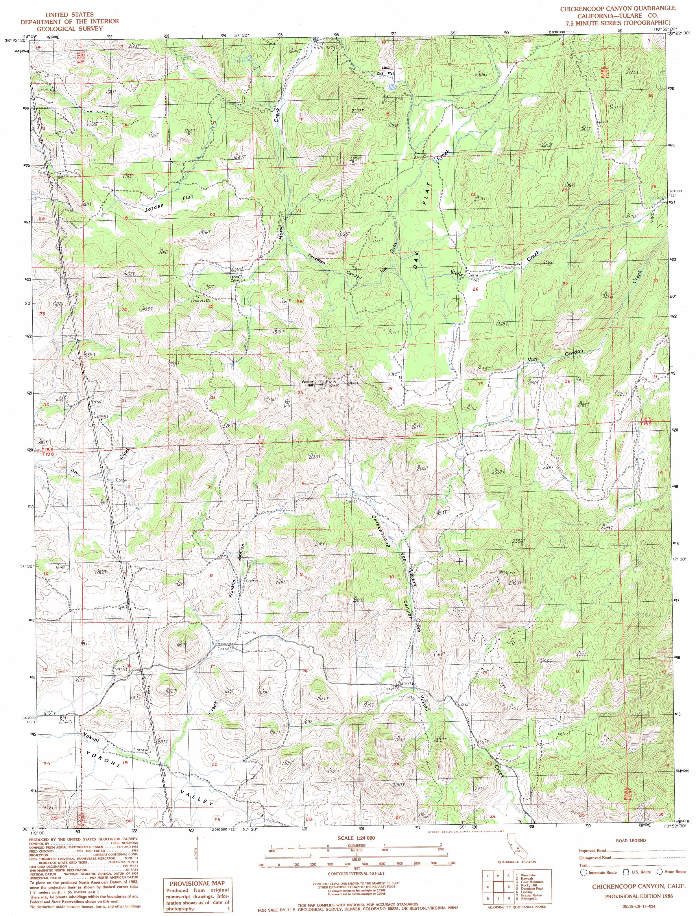
Chickencoop Canyon Topo Map California
To zoom in, hover over the map of Chickencoop Canyon
USGS Topo Quad 36118c8 - 1:24,000 scale
| Topo Map Name: | Chickencoop Canyon |
| USGS Topo Quad ID: | 36118c8 |
| Print Size: | ca. 21 1/4" wide x 27" high |
| Southeast Coordinates: | 36.25° N latitude / 118.875° W longitude |
| Map Center Coordinates: | 36.3125° N latitude / 118.9375° W longitude |
| U.S. State: | CA |
| Filename: | o36118c8.jpg |
| Download Map JPG Image: | Chickencoop Canyon topo map 1:24,000 scale |
| Map Type: | Topographic |
| Topo Series: | 7.5´ |
| Map Scale: | 1:24,000 |
| Source of Map Images: | United States Geological Survey (USGS) |
| Alternate Map Versions: |
Chickencoop Canyon CA 1986, updated 1987 Download PDF Buy paper map Chickencoop Canyon CA 1986, updated 1994 Download PDF Buy paper map Chickencoop Canyon CA 2012 Download PDF Buy paper map Chickencoop Canyon CA 2015 Download PDF Buy paper map |
1:24,000 Topo Quads surrounding Chickencoop Canyon
Stokes Mountain |
Auckland |
Shadequarter Mountain |
Giant Forest |
Lodgepole |
Ivanhoe |
Woodlake |
Kaweah |
Case Mountain |
Silver City |
Exeter |
Rocky Hill |
Chickencoop Canyon |
Dennison Peak |
Moses Mountain |
Cairns Corner |
Lindsay |
Frazier Valley |
Springville |
Camp Wishon |
Woodville |
Porterville |
Success Dam |
Globe |
Solo Peak |
> Back to 36118a1 at 1:100,000 scale
> Back to 36118a1 at 1:250,000 scale
> Back to U.S. Topo Maps home
Chickencoop Canyon topo map: Gazetteer
Chickencoop Canyon: Flats
Jordan Flat elevation 480m 1574′Little Oak Flat elevation 452m 1482′
Oak Flat elevation 564m 1850′
Chickencoop Canyon: Streams
Jim Gray Creek elevation 367m 1204′Van Gordon Creek elevation 377m 1236′
Wells Creek elevation 545m 1788′
Chickencoop Canyon: Summits
Potato Hill elevation 846m 2775′Chickencoop Canyon: Valleys
Chickencoop Canyon elevation 302m 990′Franklin Canyon elevation 215m 705′
Paradise Canyon elevation 366m 1200′
Chickencoop Canyon digital topo map on disk
Buy this Chickencoop Canyon topo map showing relief, roads, GPS coordinates and other geographical features, as a high-resolution digital map file on DVD:
Southern Sierra Nevada, California & Southern Nevada
Buy digital topo maps: Southern Sierra Nevada, California & Southern Nevada