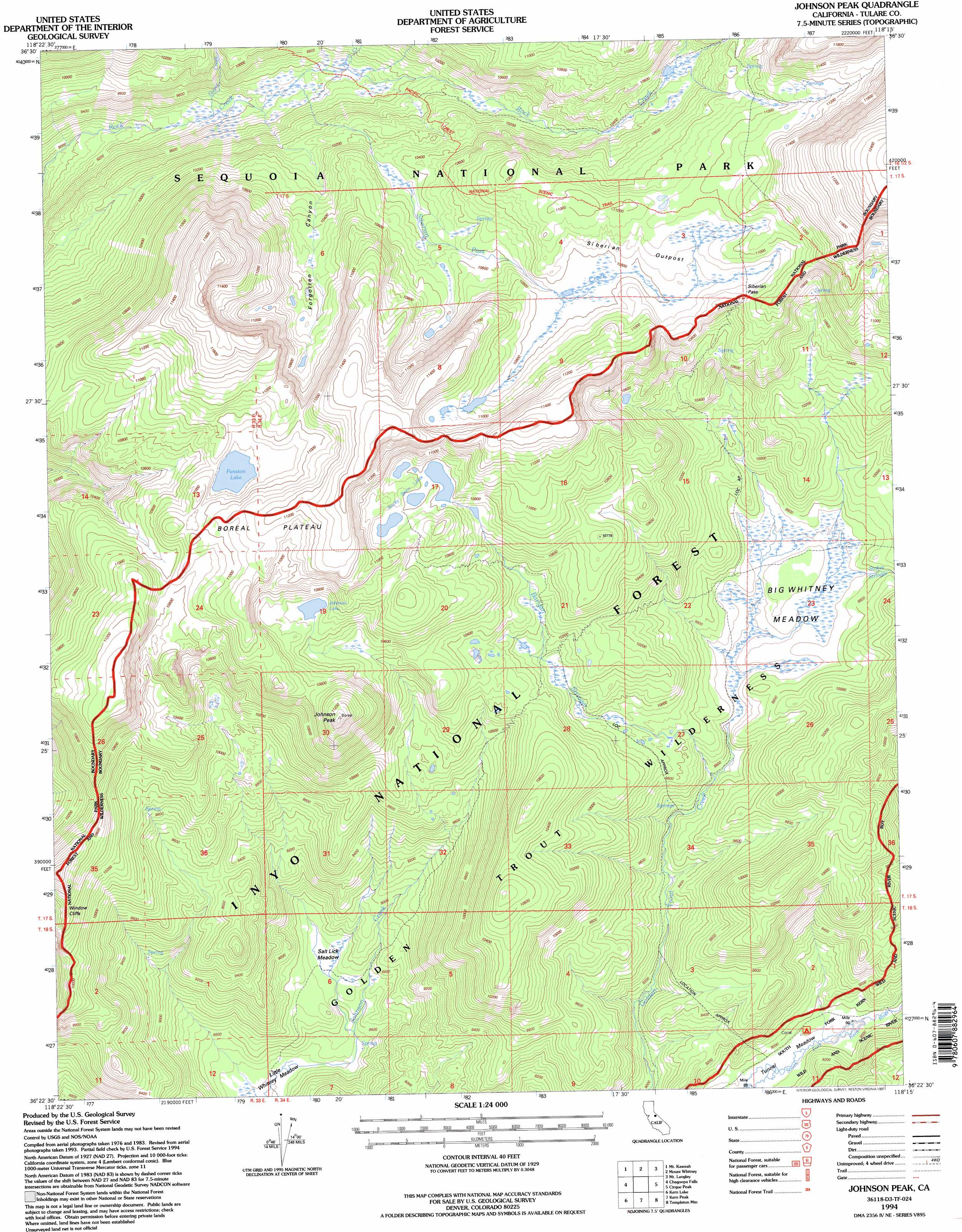
Johnson Peak Topo Map California
To zoom in, hover over the map of Johnson Peak
USGS Topo Quad 36118d3 - 1:24,000 scale
| Topo Map Name: | Johnson Peak |
| USGS Topo Quad ID: | 36118d3 |
| Print Size: | ca. 21 1/4" wide x 27" high |
| Southeast Coordinates: | 36.375° N latitude / 118.25° W longitude |
| Map Center Coordinates: | 36.4375° N latitude / 118.3125° W longitude |
| U.S. State: | CA |
| Filename: | o36118d3.jpg |
| Download Map JPG Image: | Johnson Peak topo map 1:24,000 scale |
| Map Type: | Topographic |
| Topo Series: | 7.5´ |
| Map Scale: | 1:24,000 |
| Source of Map Images: | United States Geological Survey (USGS) |
| Alternate Map Versions: |
Johnson Peak CA 1988, updated 1988 Download PDF Buy paper map Johnson Peak CA 1994, updated 1994 Download PDF Buy paper map Johnson Peak CA 1994, updated 1997 Download PDF Buy paper map Johnson Peak CA 2012 Download PDF Buy paper map Johnson Peak CA 2015 Download PDF Buy paper map |
| FStopo: | US Forest Service topo Johnson Peak is available: Download FStopo PDF Download FStopo TIF |
1:24,000 Topo Quads surrounding Johnson Peak
Sphinx Lakes |
Mount Brewer |
Mount Williamson |
Manzanar |
Union Wash |
Triple Divide Peak |
Mount Kaweah |
Mount Whitney |
Mount Langley |
Lone Pine |
Mineral King |
Chagoopa Falls |
Johnson Peak |
Cirque Peak |
Bartlett |
Quinn Peak |
Kern Lake |
Kern Peak |
Templeton Mountain |
Olancha |
Camp Nelson |
Hockett Peak |
Casa Vieja Meadows |
Monache Mountain |
Haiwee Pass |
> Back to 36118a1 at 1:100,000 scale
> Back to 36118a1 at 1:250,000 scale
> Back to U.S. Topo Maps home
Johnson Peak topo map: Gazetteer
Johnson Peak: Flats
Salt Lick Meadow elevation 2654m 8707′Tunnel Meadow elevation 2727m 8946′
Whitney Meadow elevation 2959m 9708′
Johnson Peak: Gaps
Siberian Pass elevation 3333m 10935′Johnson Peak: Lakes
Funston Lake elevation 3311m 10862′Johnson Lake elevation 3237m 10620′
Rocky Basin Lakes elevation 3287m 10784′
Johnson Peak: Plains
Boreal Plateau elevation 3399m 11151′Siberian Outpost elevation 3254m 10675′
Johnson Peak: Streams
Barigan Stringer elevation 2912m 9553′Guyot Creek elevation 2844m 9330′
Perrin Creek elevation 2935m 9629′
Siberian Pass Creek elevation 2896m 9501′
Stokes Stringer elevation 2959m 9708′
Johnson Peak: Summits
Johnson Peak elevation 3435m 11269′Mount Anna Mills elevation 3674m 12053′
Johnson Peak: Valleys
Forgotten Canyon elevation 2890m 9481′Johnson Peak digital topo map on disk
Buy this Johnson Peak topo map showing relief, roads, GPS coordinates and other geographical features, as a high-resolution digital map file on DVD:
Southern Sierra Nevada, California & Southern Nevada
Buy digital topo maps: Southern Sierra Nevada, California & Southern Nevada