Lone Pine Topo Map California
To zoom in, hover over the map of Lone Pine
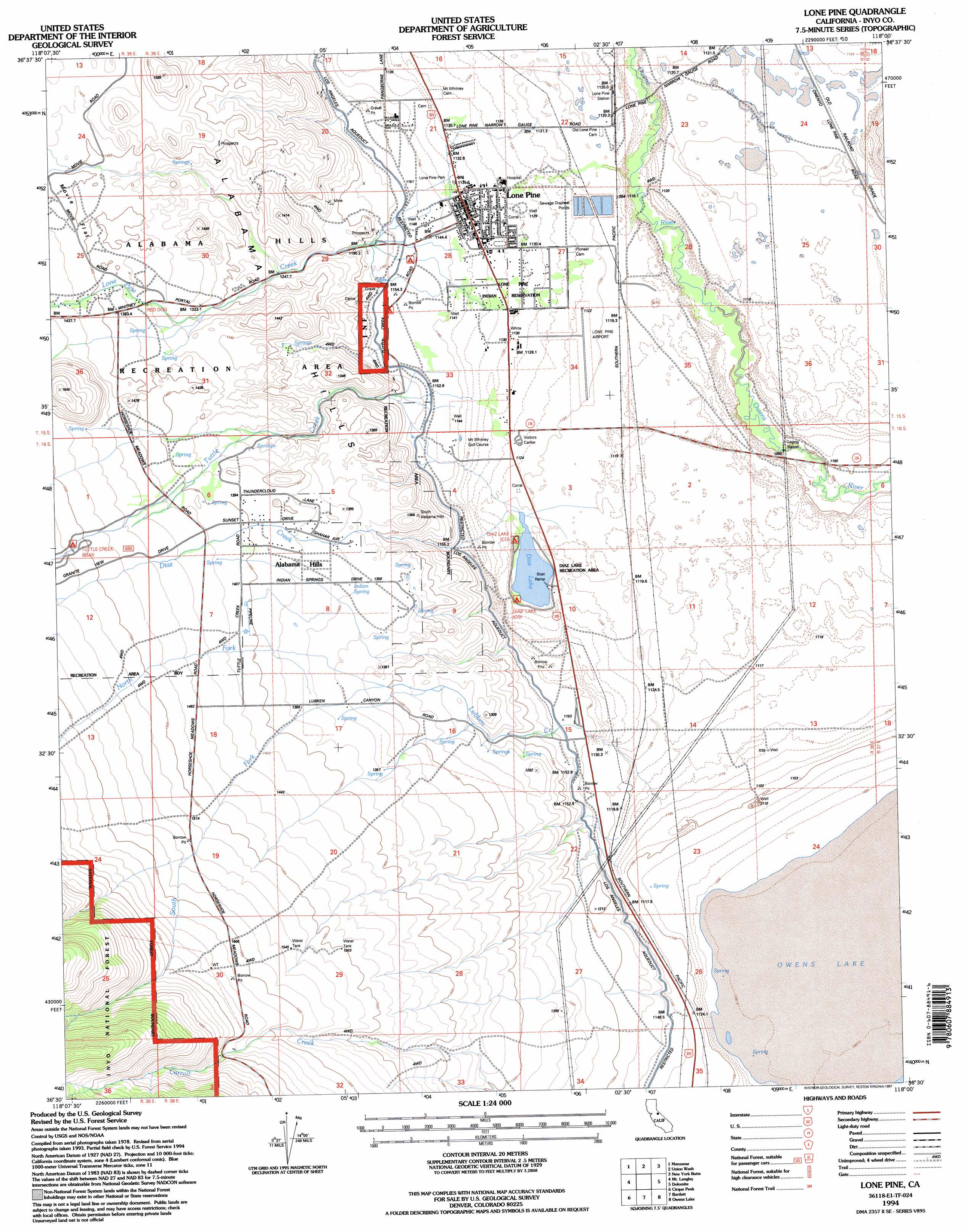
USGS Topo Quad 36118e1 - 1:24,000 scale
| Topo Map Name: | Lone Pine |
| USGS Topo Quad ID: | 36118e1 |
| Print Size: | ca. 21 1/4" wide x 27" high |
| Southeast Coordinates: | 36.5° N latitude / 118° W longitude |
| Map Center Coordinates: | 36.5625° N latitude / 118.0625° W longitude |
| U.S. State: | CA |
| Filename: | o36118e1.jpg |
| Download Map JPG Image: | Lone Pine topo map 1:24,000 scale |
| Map Type: | Topographic |
| Topo Series: | 7.5´ |
| Map Scale: | 1:24,000 |
| Source of Map Images: | United States Geological Survey (USGS) |
| Alternate Map Versions: |
Lone Pine SE CA 1975, updated 1979 Download PDF Buy paper map Lone Pine SE CA 1975, updated 1981 Download PDF Buy paper map Lone Pine CA 1982, updated 1983 Download PDF Buy paper map Lone Pine CA 1982, updated 1987 Download PDF Buy paper map Lone Pine CA 1994, updated 1997 Download PDF Buy paper map Lone Pine CA 2012 Download PDF Buy paper map Lone Pine CA 2015 Download PDF Buy paper map |
| FStopo: | US Forest Service topo Lone Pine is available: Download FStopo PDF Download FStopo TIF |
1:24,000 Topo Quads surrounding Lone Pine
Kearsarge Peak |
Independence |
Bee Springs Canyon |
Pat Keyes Canyon |
Lower Warm Springs |
Mount Williamson |
Manzanar |
Union Wash |
New York Butte |
Craig Canyon |
Mount Whitney |
Mount Langley |
Lone Pine |
Dolomite |
Cerro Gordo Peak |
Johnson Peak |
Cirque Peak |
Bartlett |
Owens Lake |
Keeler |
Kern Peak |
Templeton Mountain |
Olancha |
Vermillion Canyon |
Centennial Canyon |
> Back to 36118e1 at 1:100,000 scale
> Back to 36118a1 at 1:250,000 scale
> Back to U.S. Topo Maps home
Lone Pine topo map: Gazetteer
Lone Pine: Airports
Lone Pine Airport elevation 1126m 3694′Lone Pine: Flats
Movie Flat elevation 1403m 4603′Lone Pine: Parks
Diaz Lake Recreation Area elevation 1120m 3674′Lone Pine Park elevation 1137m 3730′
Lone Pine: Populated Places
Alabama Hills elevation 1382m 4534′Lone Pine elevation 1136m 3727′
Lone Pine: Ranges
Alabama Hills elevation 1405m 4609′Lone Pine: Reservoirs
Diaz Lake elevation 1120m 3674′Lone Pine: Springs
Indian Spring elevation 1362m 4468′Lone Pine: Streams
Diaz Creek elevation 1120m 3674′Lone Pine Creek elevation 1155m 3789′
Lubken Creek elevation 1156m 3792′
North Fork Lubken Creek elevation 1304m 4278′
South Fork Lubken Creek elevation 1304m 4278′
Tuttle Creek elevation 1158m 3799′
Lone Pine digital topo map on disk
Buy this Lone Pine topo map showing relief, roads, GPS coordinates and other geographical features, as a high-resolution digital map file on DVD:
Southern Sierra Nevada, California & Southern Nevada
Buy digital topo maps: Southern Sierra Nevada, California & Southern Nevada