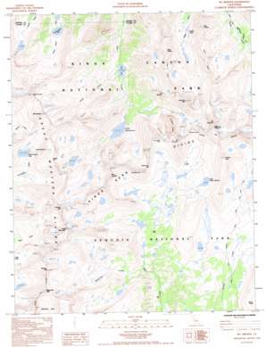
Mount Brewer Topo Map California
To zoom in, hover over the map of Mount Brewer
USGS Topo Quad 36118f4 - 1:24,000 scale
| Topo Map Name: | Mount Brewer |
| USGS Topo Quad ID: | 36118f4 |
| Print Size: | ca. 21 1/4" wide x 27" high |
| Southeast Coordinates: | 36.625° N latitude / 118.375° W longitude |
| Map Center Coordinates: | 36.6875° N latitude / 118.4375° W longitude |
| U.S. State: | CA |
| Filename: | o36118f4.jpg |
| Download Map JPG Image: | Mount Brewer topo map 1:24,000 scale |
| Map Type: | Topographic |
| Topo Series: | 7.5´ |
| Map Scale: | 1:24,000 |
| Source of Map Images: | United States Geological Survey (USGS) |
| Alternate Map Versions: |
Mt. Brewer CA 1985, updated 1985 Download PDF Buy paper map Mt. Brewer CA 1993, updated 1994 Download PDF Buy paper map Mt. Brewer CA 1993, updated 1994 Download PDF Buy paper map Mount Brewer CA 2012 Download PDF Buy paper map Mount Brewer CA 2015 Download PDF Buy paper map |
1:24,000 Topo Quads surrounding Mount Brewer
> Back to 36118e1 at 1:100,000 scale
> Back to 36118a1 at 1:250,000 scale
> Back to U.S. Topo Maps home
Mount Brewer topo map: Gazetteer
Mount Brewer: Gaps
Harrison Pass elevation 3883m 12739′Longley Pass elevation 3797m 12457′
Lucys Foot Pass elevation 3713m 12181′
Millys Foot Pass elevation 3733m 12247′
Mount Brewer: Lakes
East Lake elevation 2892m 9488′Lake Reflection elevation 3059m 10036′
Lake South America elevation 3643m 11952′
North Guard Lake elevation 3077m 10095′
South Guard Lake elevation 3556m 11666′
Vidette Lakes elevation 3216m 10551′
Mount Brewer: Pillars
Ericson Crags elevation 3879m 12726′The Minster elevation 3625m 11893′
Mount Brewer: Ridges
East Spur elevation 3821m 12536′Kern Ridge elevation 4131m 13553′
Kings-Kern Divide elevation 3757m 12326′
West Spur elevation 3705m 12155′
Mount Brewer: Streams
Milestone Creek elevation 3086m 10124′Ouzel Creek elevation 2888m 9475′
Mount Brewer: Summits
Caltech Peak elevation 4207m 13802′Centennial Peak elevation 4026m 13208′
Deerhorn Mountain elevation 4004m 13136′
East Vidette elevation 3728m 12230′
Gregorys Monument elevation 4223m 13854′
Midway Mountain elevation 4140m 13582′
Milestone Mountain elevation 4062m 13326′
Mount Brewer elevation 4114m 13497′
Mount Ericsson elevation 4138m 13576′
Mount Farquhar elevation 3870m 12696′
Mount Genevra elevation 3983m 13067′
Mount Jordan elevation 4045m 13270′
Mount Stanford elevation 4253m 13953′
North Guard elevation 3982m 13064′
South Guard elevation 4021m 13192′
Table Mountain elevation 4119m 13513′
Tawny Point elevation 3716m 12191′
Thunder Mountain elevation 4122m 13523′
Mount Brewer digital topo map on disk
Buy this Mount Brewer topo map showing relief, roads, GPS coordinates and other geographical features, as a high-resolution digital map file on DVD:
Southern Sierra Nevada, California & Southern Nevada
Buy digital topo maps: Southern Sierra Nevada, California & Southern Nevada


