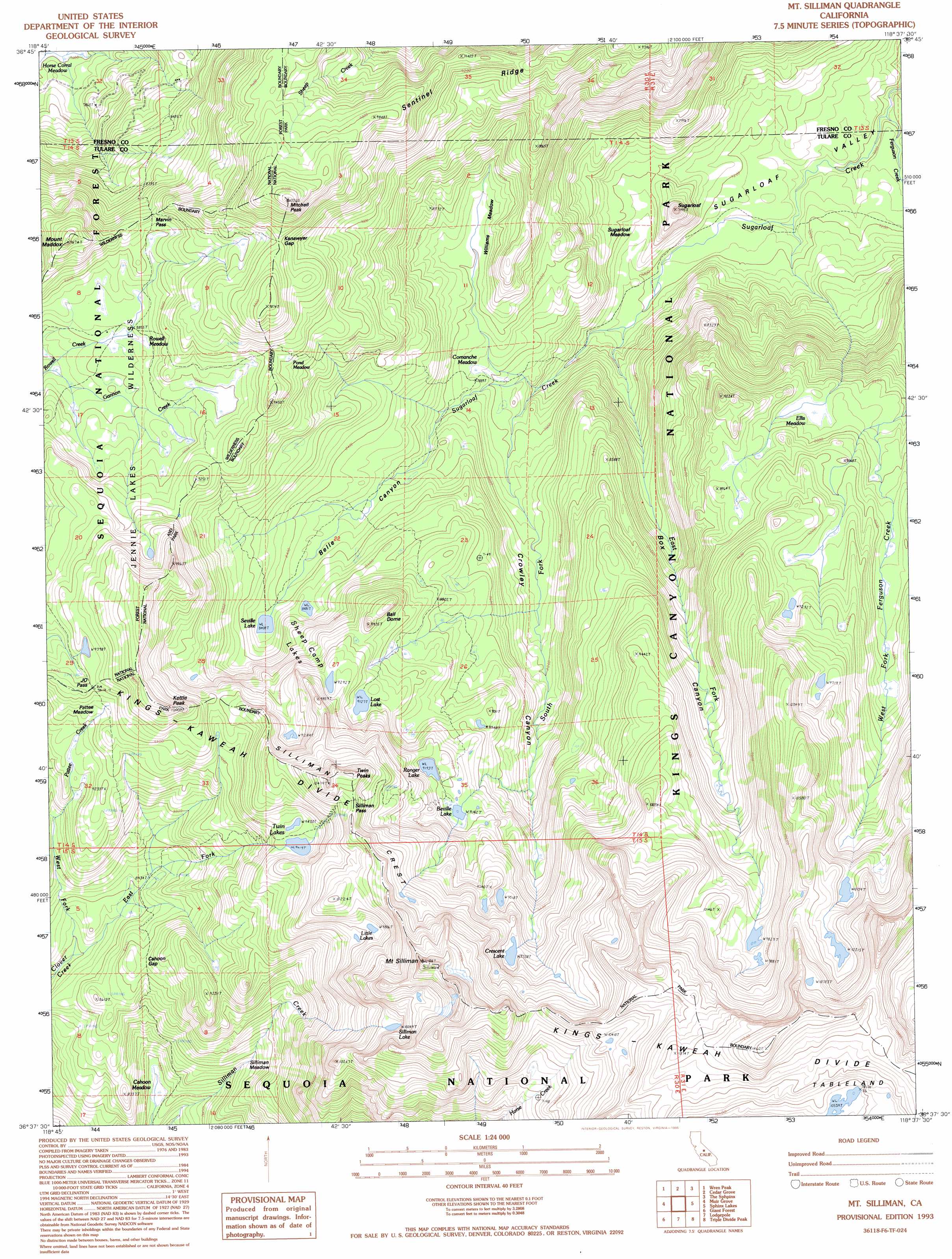
Mount Stillman Topo Map California
To zoom in, hover over the map of Mount Stillman
USGS Topo Quad 36118f6 - 1:24,000 scale
| Topo Map Name: | Mount Stillman |
| USGS Topo Quad ID: | 36118f6 |
| Print Size: | ca. 21 1/4" wide x 27" high |
| Southeast Coordinates: | 36.625° N latitude / 118.625° W longitude |
| Map Center Coordinates: | 36.6875° N latitude / 118.6875° W longitude |
| U.S. State: | CA |
| Filename: | o36118f6.jpg |
| Download Map JPG Image: | Mount Stillman topo map 1:24,000 scale |
| Map Type: | Topographic |
| Topo Series: | 7.5´ |
| Map Scale: | 1:24,000 |
| Source of Map Images: | United States Geological Survey (USGS) |
| Alternate Map Versions: |
Mt. Silliman CA 1988, updated 1988 Download PDF Buy paper map Mt. Silliman CA 1993, updated 1995 Download PDF Buy paper map Mt. Silliman CA 1993, updated 1995 Download PDF Buy paper map Mount Silliman CA 2012 Download PDF Buy paper map Mount Silliman CA 2015 Download PDF Buy paper map |
| FStopo: | US Forest Service topo Mount Silliman is available: Download FStopo PDF Download FStopo TIF |
1:24,000 Topo Quads surrounding Mount Stillman
Rough Spur |
Tehipite Dome |
Slide Bluffs |
Marion Peak |
Mount Pinchot |
Hume |
Wren Peak |
Cedar Grove |
The Sphinx |
Mount Clarence King |
General Grant Grove |
Muir Grove |
Mount Stillman |
Sphinx Lakes |
Mount Brewer |
Shadequarter Mountain |
Giant Forest |
Lodgepole |
Triple Divide Peak |
Mount Kaweah |
Kaweah |
Case Mountain |
Silver City |
Mineral King |
Chagoopa Falls |
> Back to 36118e1 at 1:100,000 scale
> Back to 36118a1 at 1:250,000 scale
> Back to U.S. Topo Maps home
Mount Stillman topo map: Gazetteer
Mount Stillman: Basins
Sugarloaf Valley elevation 2147m 7043′Mount Stillman: Capes
Profile View elevation 2837m 9307′Mount Stillman: Flats
Comanche Meadow elevation 2386m 7828′Ellis Meadow elevation 2657m 8717′
Pattee Meadow elevation 2821m 9255′
Pond Meadow elevation 2823m 9261′
Rowell Meadow elevation 2686m 8812′
Silliman Meadow elevation 2363m 7752′
Sugarloaf Meadow elevation 2225m 7299′
Williams Meadow elevation 2447m 8028′
Mount Stillman: Gaps
Cahoon Gap elevation 2639m 8658′J.O. Pass elevation 2871m 9419′
Kanawyer Gap elevation 2941m 9648′
Marvin Pass elevation 2775m 9104′
Silliman Pass elevation 3101m 10173′
Mount Stillman: Lakes
Beville Lake elevation 2792m 9160′Crescent Lake elevation 2978m 9770′
Little Lake elevation 2990m 9809′
Little Lakes elevation 2990m 9809′
Lost Lake elevation 2783m 9130′
Ranger Lake elevation 2804m 9199′
Seville Lake elevation 2564m 8412′
Sheep Camp Lakes elevation 2737m 8979′
Silliman Lake elevation 3064m 10052′
Twin Lakes elevation 2872m 9422′
Mount Stillman: Ridges
Silliman Crest elevation 2879m 9445′Mount Stillman: Streams
East Fork Clover Creek elevation 2490m 8169′East Fork Sugarloaf Creek elevation 2200m 7217′
Ferguson Creek elevation 2137m 7011′
South Fork Sugarloaf Creek elevation 2288m 7506′
West Fork Clover Creek elevation 2490m 8169′
Mount Stillman: Summits
Ball Dome elevation 2866m 9402′Kettle Peak elevation 3058m 10032′
Mitchell Peak elevation 3124m 10249′
Mount Maddox elevation 2931m 9616′
Mount Silliman elevation 3397m 11145′
Sugarloaf elevation 2424m 7952′
Twin Peaks elevation 3135m 10285′
Mount Stillman: Valleys
Belle Canyon elevation 2312m 7585′Box Canyon elevation 2998m 9835′
Crowley Canyon elevation 2890m 9481′
Mount Stillman digital topo map on disk
Buy this Mount Stillman topo map showing relief, roads, GPS coordinates and other geographical features, as a high-resolution digital map file on DVD:
Southern Sierra Nevada, California & Southern Nevada
Buy digital topo maps: Southern Sierra Nevada, California & Southern Nevada