Wren Peak Topo Map California
To zoom in, hover over the map of Wren Peak
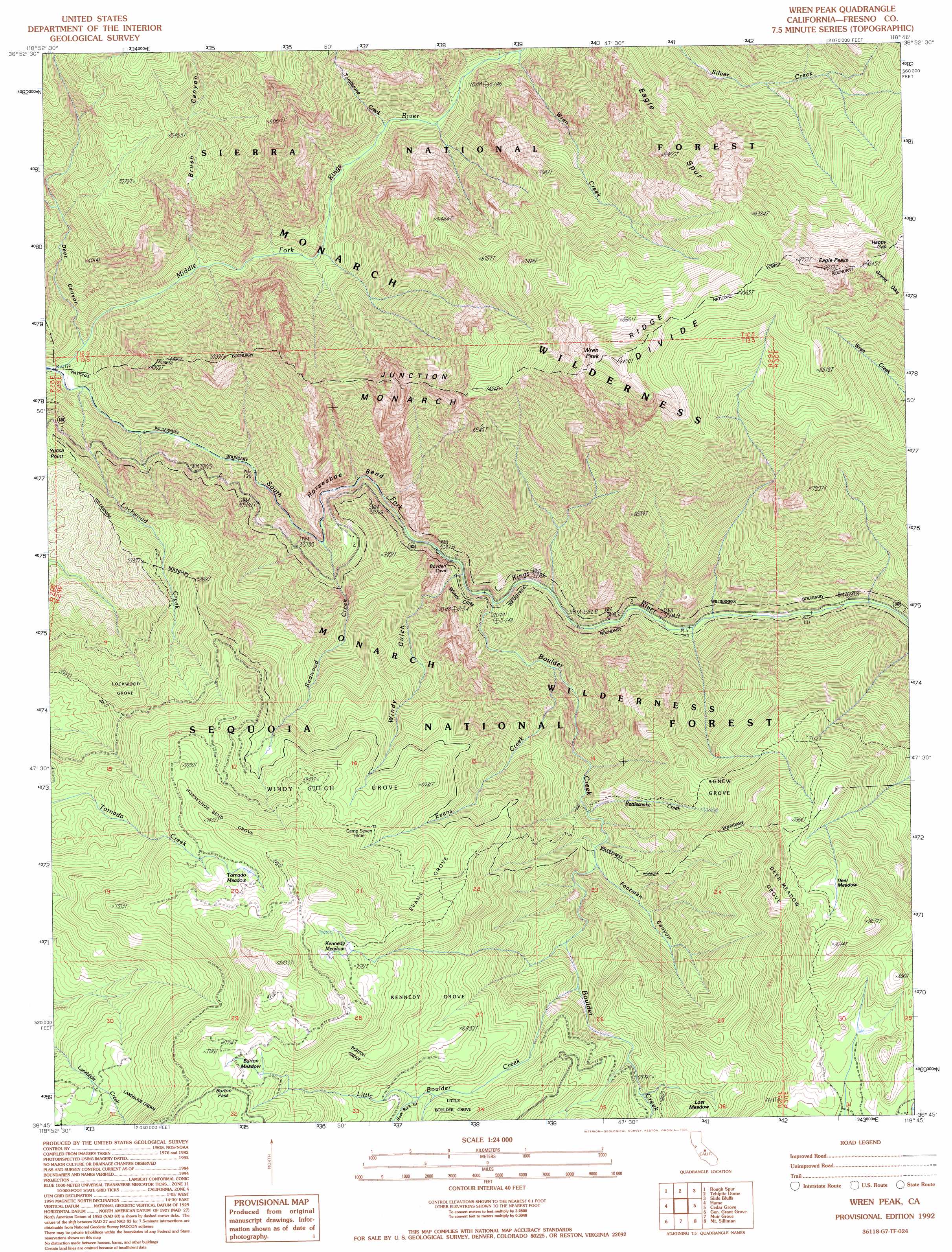
USGS Topo Quad 36118g7 - 1:24,000 scale
| Topo Map Name: | Wren Peak |
| USGS Topo Quad ID: | 36118g7 |
| Print Size: | ca. 21 1/4" wide x 27" high |
| Southeast Coordinates: | 36.75° N latitude / 118.75° W longitude |
| Map Center Coordinates: | 36.8125° N latitude / 118.8125° W longitude |
| U.S. State: | CA |
| Filename: | o36118g7.jpg |
| Download Map JPG Image: | Wren Peak topo map 1:24,000 scale |
| Map Type: | Topographic |
| Topo Series: | 7.5´ |
| Map Scale: | 1:24,000 |
| Source of Map Images: | United States Geological Survey (USGS) |
| Alternate Map Versions: |
Wren Peak CA 1986, updated 1987 Download PDF Buy paper map Wren Peak CA 1992, updated 1995 Download PDF Buy paper map Wren Peak CA 1992, updated 1995 Download PDF Buy paper map Wren Peak CA 2012 Download PDF Buy paper map Wren Peak CA 2015 Download PDF Buy paper map |
| FStopo: | US Forest Service topo Wren Peak is available: Download FStopo PDF Download FStopo TIF |
1:24,000 Topo Quads surrounding Wren Peak
Nelson Mountain |
Courtright Reservoir |
Blackcap Mountain |
Mount Goddard |
North Palisade |
Patterson Mountain |
Rough Spur |
Tehipite Dome |
Slide Bluffs |
Marion Peak |
Verplank Ridge |
Hume |
Wren Peak |
Cedar Grove |
The Sphinx |
Miramonte |
General Grant Grove |
Muir Grove |
Mount Stillman |
Sphinx Lakes |
Auckland |
Shadequarter Mountain |
Giant Forest |
Lodgepole |
Triple Divide Peak |
> Back to 36118e1 at 1:100,000 scale
> Back to 36118a1 at 1:250,000 scale
> Back to U.S. Topo Maps home
Wren Peak topo map: Gazetteer
Wren Peak: Bends
Horseshoe Bend elevation 882m 2893′Wren Peak: Capes
Yucca Point elevation 1295m 4248′Wren Peak: Cliffs
Windy Cliffs elevation 1426m 4678′Wren Peak: Flats
Burton Meadow elevation 2299m 7542′Deer Meadow elevation 2480m 8136′
Kennedy Meadow elevation 2286m 7500′
Lost Meadow elevation 1990m 6528′
Tornado Meadow elevation 2236m 7335′
Wren Peak: Gaps
Burton Pass elevation 2343m 7687′Happy Gap elevation 2816m 9238′
Wren Peak: Ridges
Eagle Spur elevation 2391m 7844′Junction Ridge elevation 2441m 8008′
Wren Peak: Streams
Boulder Creek elevation 965m 3166′Buck Rock Creek elevation 1957m 6420′
Evans Creek elevation 1105m 3625′
Little Boulder Creek elevation 1690m 5544′
Lockwood Creek elevation 723m 2372′
Rattlesnake Creek elevation 1452m 4763′
Redwood Creek elevation 851m 2791′
Tombstone Creek elevation 971m 3185′
Wren Creek elevation 1132m 3713′
Wren Peak: Summits
Wren Peak elevation 2851m 9353′Wren Peak: Valleys
Brush Canyon elevation 785m 2575′Footman Canyon elevation 1498m 4914′
Windy Gulch elevation 991m 3251′
Wren Peak: Woods
Agnew Grove elevation 1946m 6384′Burton Grove elevation 2188m 7178′
Deer Meadow Grove elevation 2059m 6755′
Evans Grove elevation 2069m 6788′
Horseshoe Bend Grove elevation 2221m 7286′
Kennedy Grove elevation 2172m 7125′
Landslide Grove elevation 2080m 6824′
Lockwood Grove elevation 1791m 5875′
Windy Gulch Grove elevation 1986m 6515′
Wren Peak digital topo map on disk
Buy this Wren Peak topo map showing relief, roads, GPS coordinates and other geographical features, as a high-resolution digital map file on DVD:
Southern Sierra Nevada, California & Southern Nevada
Buy digital topo maps: Southern Sierra Nevada, California & Southern Nevada