Aberdeen Topo Map California
To zoom in, hover over the map of Aberdeen
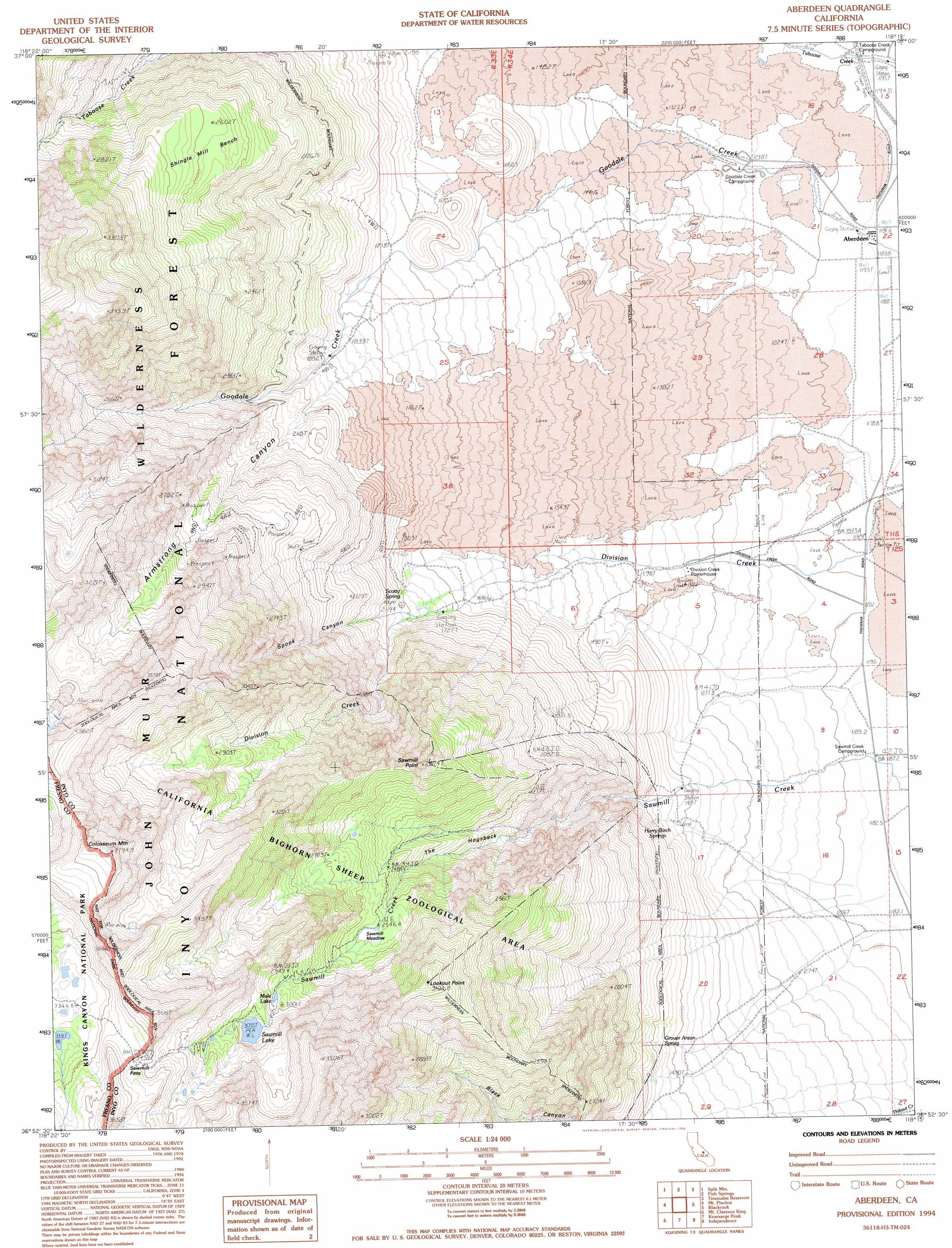
USGS Topo Quad 36118h3 - 1:24,000 scale
| Topo Map Name: | Aberdeen |
| USGS Topo Quad ID: | 36118h3 |
| Print Size: | ca. 21 1/4" wide x 27" high |
| Southeast Coordinates: | 36.875° N latitude / 118.25° W longitude |
| Map Center Coordinates: | 36.9375° N latitude / 118.3125° W longitude |
| U.S. State: | CA |
| Filename: | o36118h3.jpg |
| Download Map JPG Image: | Aberdeen topo map 1:24,000 scale |
| Map Type: | Topographic |
| Topo Series: | 7.5´ |
| Map Scale: | 1:24,000 |
| Source of Map Images: | United States Geological Survey (USGS) |
| Alternate Map Versions: |
Aberdeen CA 1985, updated 1985 Download PDF Buy paper map Aberdeen CA 1985, updated 1985 Download PDF Buy paper map Aberdeen CA 1994, updated 1994 Download PDF Buy paper map Aberdeen CA 1994, updated 1997 Download PDF Buy paper map Aberdeen CA 2012 Download PDF Buy paper map Aberdeen CA 2015 Download PDF Buy paper map |
| FStopo: | US Forest Service topo Aberdeen is available: Download FStopo PDF Download FStopo TIF |
1:24,000 Topo Quads surrounding Aberdeen
Mount Thompson |
Coyote Flat |
Big Pine |
Uhlmeyer Spring |
Cowhorn Valley |
North Palisade |
Split Mountain |
Fish Springs |
Tinemaha Reservoir |
Waucoba Mountain |
Marion Peak |
Mount Pinchot |
Aberdeen |
Blackrock |
Mazourka Peak |
The Sphinx |
Mount Clarence King |
Kearsarge Peak |
Independence |
Bee Springs Canyon |
Sphinx Lakes |
Mount Brewer |
Mount Williamson |
Manzanar |
Union Wash |
> Back to 36118e1 at 1:100,000 scale
> Back to 36118a1 at 1:250,000 scale
> Back to U.S. Topo Maps home
Aberdeen topo map: Gazetteer
Aberdeen: Benches
Shingle Mill Bench elevation 2610m 8562′Aberdeen: Flats
Sawmill Meadows elevation 2570m 8431′Aberdeen: Gaps
Sawmill Pass elevation 3467m 11374′Aberdeen: Lakes
Sawmill Lake elevation 3055m 10022′Aberdeen: Mines
Firecracker Mine elevation 2674m 8772′Glacier Mines elevation 2567m 8421′
Pinnacle Mine elevation 2750m 9022′
Rudy Mine elevation 2661m 8730′
Sierra View Mine elevation 2511m 8238′
Valley View Mine elevation 2324m 7624′
Aberdeen: Populated Places
Aberdeen elevation 1193m 3914′Aberdeen: Reservoirs
Mule Lake elevation 3018m 9901′Aberdeen: Ridges
The Hogsback elevation 2324m 7624′Aberdeen: Springs
Grover Anton Spring elevation 1620m 5314′Harry Birch Springs elevation 1493m 4898′
Scotty Spring elevation 1769m 5803′
Aberdeen: Streams
Division Creek elevation 1478m 4849′Aberdeen: Summits
Colosseum Mountain elevation 3660m 12007′Lookout Point elevation 3020m 9908′
Sawmill Point elevation 2808m 9212′
Aberdeen: Valleys
Armstrong Canyon elevation 1958m 6423′Spook Canyon elevation 1799m 5902′
Aberdeen digital topo map on disk
Buy this Aberdeen topo map showing relief, roads, GPS coordinates and other geographical features, as a high-resolution digital map file on DVD:
Southern Sierra Nevada, California & Southern Nevada
Buy digital topo maps: Southern Sierra Nevada, California & Southern Nevada