Mount Pinchot Topo Map California
To zoom in, hover over the map of Mount Pinchot
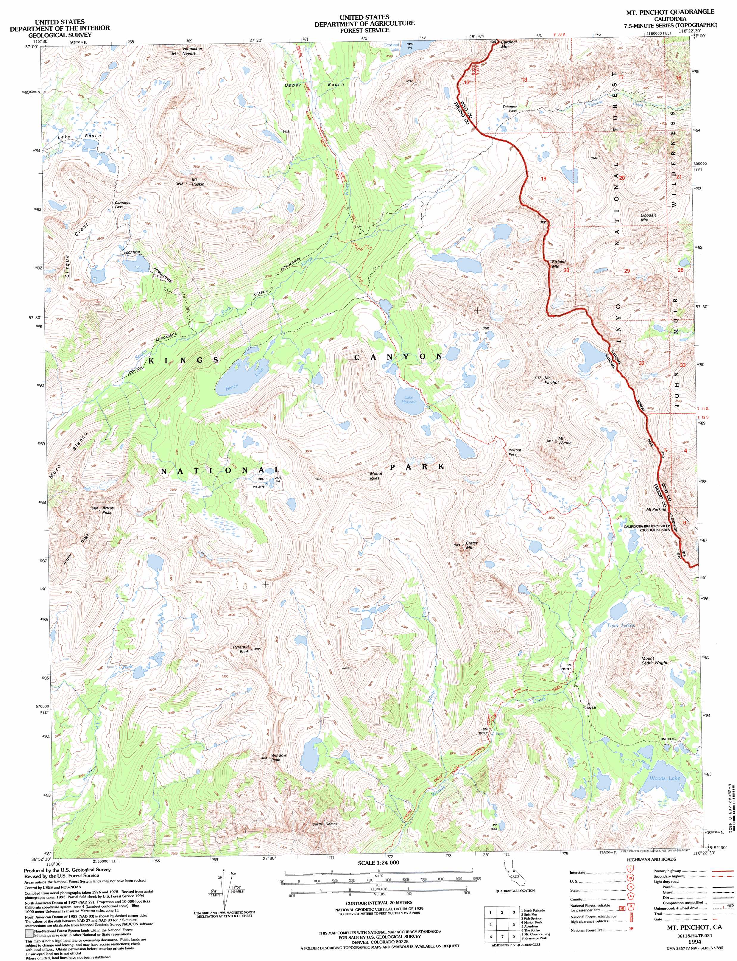
USGS Topo Quad 36118h4 - 1:24,000 scale
| Topo Map Name: | Mount Pinchot |
| USGS Topo Quad ID: | 36118h4 |
| Print Size: | ca. 21 1/4" wide x 27" high |
| Southeast Coordinates: | 36.875° N latitude / 118.375° W longitude |
| Map Center Coordinates: | 36.9375° N latitude / 118.4375° W longitude |
| U.S. State: | CA |
| Filename: | o36118h4.jpg |
| Download Map JPG Image: | Mount Pinchot topo map 1:24,000 scale |
| Map Type: | Topographic |
| Topo Series: | 7.5´ |
| Map Scale: | 1:24,000 |
| Source of Map Images: | United States Geological Survey (USGS) |
| Alternate Map Versions: |
Mt. Pinchot CA 1985, updated 1985 Download PDF Buy paper map Mt. Pinchot CA 1985, updated 1985 Download PDF Buy paper map Mt. Pinchot CA 1992, updated 1994 Download PDF Buy paper map Mt. Pinchot CA 1994, updated 1997 Download PDF Buy paper map Mount Pinchot CA 2012 Download PDF Buy paper map Mount Pinchot CA 2015 Download PDF Buy paper map |
| FStopo: | US Forest Service topo Mount Pinchot is available: Download FStopo PDF Download FStopo TIF |
1:24,000 Topo Quads surrounding Mount Pinchot
Mount Darwin |
Mount Thompson |
Coyote Flat |
Big Pine |
Uhlmeyer Spring |
Mount Goddard |
North Palisade |
Split Mountain |
Fish Springs |
Tinemaha Reservoir |
Slide Bluffs |
Marion Peak |
Mount Pinchot |
Aberdeen |
Blackrock |
Cedar Grove |
The Sphinx |
Mount Clarence King |
Kearsarge Peak |
Independence |
Mount Stillman |
Sphinx Lakes |
Mount Brewer |
Mount Williamson |
Manzanar |
> Back to 36118e1 at 1:100,000 scale
> Back to 36118a1 at 1:250,000 scale
> Back to U.S. Topo Maps home
Mount Pinchot topo map: Gazetteer
Mount Pinchot: Gaps
Cartridge Pass elevation 3603m 11820′Pinchot Pass elevation 3654m 11988′
Taboose Pass elevation 3485m 11433′
Mount Pinchot: Lakes
Bench Lake elevation 3220m 10564′Cardinal Lake elevation 3495m 11466′
Lake Marjorie elevation 3390m 11122′
Twin Lakes elevation 3241m 10633′
Woods Lake elevation 3271m 10731′
Mount Pinchot: Pillars
Castle Domes elevation 2982m 9783′Mount Pinchot: Streams
White Fork elevation 2808m 9212′Mount Pinchot: Summits
Arrow Peak elevation 3886m 12749′Cardinal Mountain elevation 3921m 12864′
Crater Mountain elevation 3772m 12375′
Goodale Mountain elevation 3779m 12398′
Mount Cedric Wright elevation 3768m 12362′
Mount Ickes elevation 3936m 12913′
Mount Perkins elevation 3707m 12162′
Mount Pinchot elevation 4000m 13123′
Mount Ruskin elevation 3868m 12690′
Mount Wynne elevation 4008m 13149′
Pyramid Peak elevation 3811m 12503′
Striped Mountain elevation 3859m 12660′
Vennacher Needle elevation 3880m 12729′
Window Peak elevation 3690m 12106′
Mount Pinchot digital topo map on disk
Buy this Mount Pinchot topo map showing relief, roads, GPS coordinates and other geographical features, as a high-resolution digital map file on DVD:
Southern Sierra Nevada, California & Southern Nevada
Buy digital topo maps: Southern Sierra Nevada, California & Southern Nevada