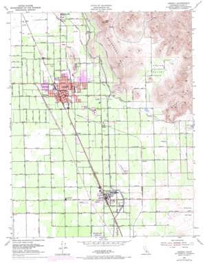
Lindsay Topo Map California
To zoom in, hover over the map of Lindsay
USGS Topo Quad 36119b1 - 1:24,000 scale
| Topo Map Name: | Lindsay |
| USGS Topo Quad ID: | 36119b1 |
| Print Size: | ca. 21 1/4" wide x 27" high |
| Southeast Coordinates: | 36.125° N latitude / 119° W longitude |
| Map Center Coordinates: | 36.1875° N latitude / 119.0625° W longitude |
| U.S. State: | CA |
| Filename: | o36119b1.jpg |
| Download Map JPG Image: | Lindsay topo map 1:24,000 scale |
| Map Type: | Topographic |
| Topo Series: | 7.5´ |
| Map Scale: | 1:24,000 |
| Source of Map Images: | United States Geological Survey (USGS) |
| Alternate Map Versions: |
Lindsay CA 1951, updated 1952 Download PDF Buy paper map Lindsay CA 1951, updated 1956 Download PDF Buy paper map Lindsay CA 1951, updated 1971 Download PDF Buy paper map Lindsay CA 2012 Download PDF Buy paper map Lindsay CA 2015 Download PDF Buy paper map |
1:24,000 Topo Quads surrounding Lindsay
> Back to 36119a1 at 1:100,000 scale
> Back to 36118a1 at 1:250,000 scale
> Back to U.S. Topo Maps home
Lindsay topo map: Gazetteer
Lindsay: Airports
Eckert Field elevation 130m 426′Lindsay: Basins
Round Valley elevation 158m 518′Lindsay: Canals
Friant-Kern Canal elevation 124m 406′Lindsay Strathmore Irrigation Ditch elevation 212m 695′
Lindsay: Parks
Harvard Park elevation 117m 383′Lindsay City Park elevation 114m 374′
Olive Bowl Park elevation 116m 380′
Lindsay: Populated Places
Abilene elevation 124m 406′Burr elevation 108m 354′
El Mirador elevation 148m 485′
Fayette elevation 124m 406′
Gillete elevation 136m 446′
Hawkins (historical) elevation 119m 390′
Lindsay elevation 118m 387′
Lucca elevation 111m 364′
Mirador elevation 136m 446′
Orlem (historical) elevation 132m 433′
Portex (historical) elevation 134m 439′
Prewit (historical) elevation 140m 459′
Reynolds (historical) elevation 120m 393′
Sierra Heights elevation 125m 410′
Stout elevation 119m 390′
Strathmore elevation 122m 400′
Tiffin (historical) elevation 143m 469′
Tonyville elevation 110m 360′
Vance elevation 111m 364′
Worthing (historical) elevation 118m 387′
Lindsay: Post Offices
Linday Post Office elevation 117m 383′Strathmore Post Office elevation 123m 403′
Lindsay: Ridges
Chrysoprase Hill elevation 135m 442′Elephant Back elevation 335m 1099′
Todds Hill elevation 140m 459′
Lindsay: Streams
Frazier Creek elevation 136m 446′Lindsay: Summits
Lindsay Peak elevation 406m 1332′Rocky Hills elevation 396m 1299′
Lindsay digital topo map on disk
Buy this Lindsay topo map showing relief, roads, GPS coordinates and other geographical features, as a high-resolution digital map file on DVD:
Southern Sierra Nevada, California & Southern Nevada
Buy digital topo maps: Southern Sierra Nevada, California & Southern Nevada


