Hanford Topo Map California
To zoom in, hover over the map of Hanford
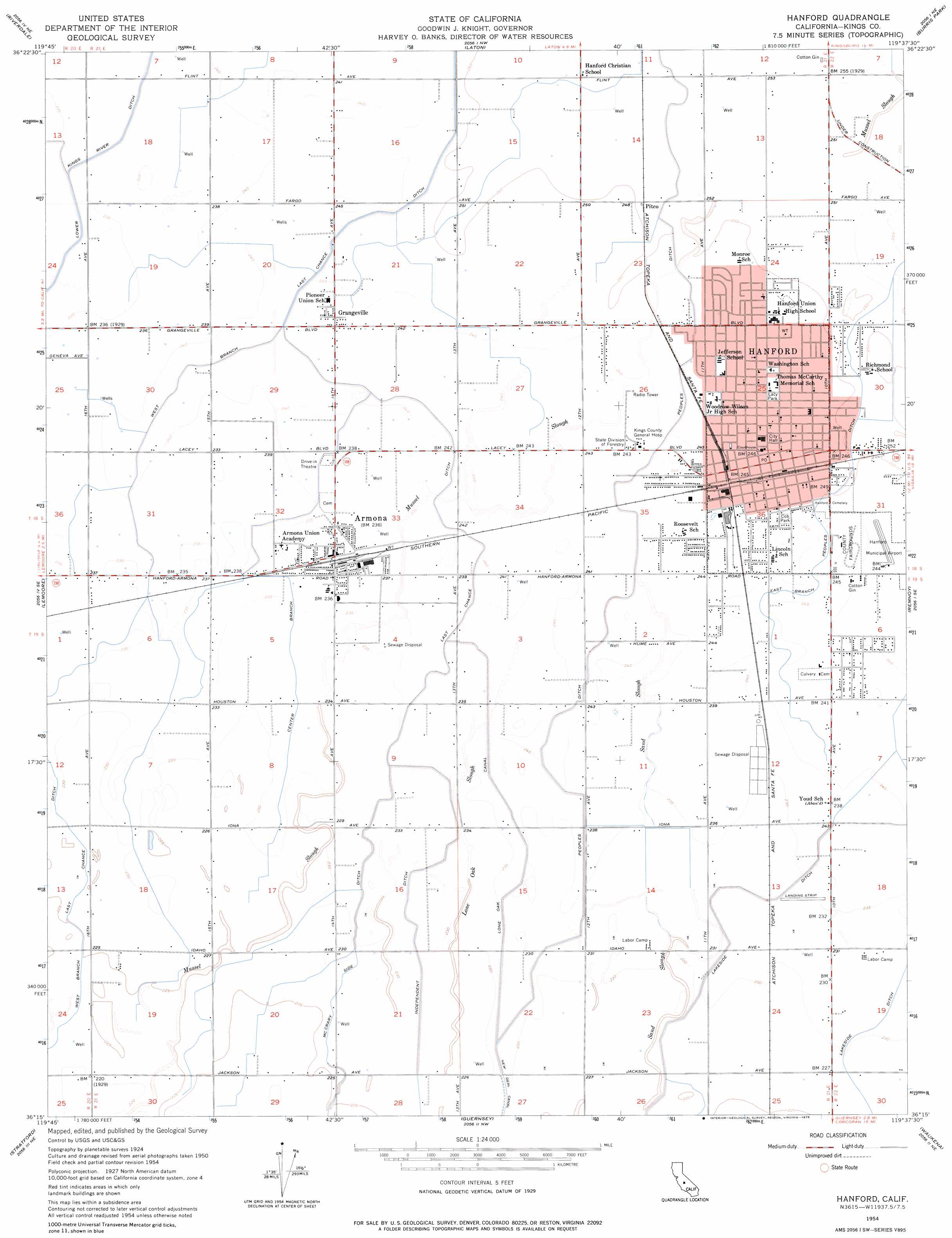
USGS Topo Quad 36119c6 - 1:24,000 scale
| Topo Map Name: | Hanford |
| USGS Topo Quad ID: | 36119c6 |
| Print Size: | ca. 21 1/4" wide x 27" high |
| Southeast Coordinates: | 36.25° N latitude / 119.625° W longitude |
| Map Center Coordinates: | 36.3125° N latitude / 119.6875° W longitude |
| U.S. State: | CA |
| Filename: | o36119c6.jpg |
| Download Map JPG Image: | Hanford topo map 1:24,000 scale |
| Map Type: | Topographic |
| Topo Series: | 7.5´ |
| Map Scale: | 1:24,000 |
| Source of Map Images: | United States Geological Survey (USGS) |
| Alternate Map Versions: |
Hanford CA 1954, updated 1957 Download PDF Buy paper map Hanford CA 1954, updated 1975 Download PDF Buy paper map Hanford CA 1976, updated 1980 Download PDF Buy paper map Hanford CA 2012 Download PDF Buy paper map Hanford CA 2015 Download PDF Buy paper map |
1:24,000 Topo Quads surrounding Hanford
Raisin |
Caruthers |
Conejo |
Selma |
Reedley |
Burrel |
Riverdale |
Laton |
Burris Park |
Traver |
Vanguard |
Lemoore |
Hanford |
Remnoy |
Goshen |
Westhaven |
Stratford |
Guernsey |
Waukena |
Paige |
Kettleman City |
Stratford Se |
El Rico Ranch |
Corcoran |
Taylor Weir |
> Back to 36119a1 at 1:100,000 scale
> Back to 36118a1 at 1:250,000 scale
> Back to U.S. Topo Maps home
Hanford topo map: Gazetteer
Hanford: Airports
Blair Strip elevation 72m 236′Hanford Community Medical Center Helistop elevation 76m 249′
Hanford Municipal Airport elevation 76m 249′
Hanford: Canals
Center Branch elevation 72m 236′Independent Ditch elevation 71m 232′
Last Chance Ditch elevation 77m 252′
Lower Kings River Ditch elevation 73m 239′
McCrary Side Ditch elevation 70m 229′
Hanford: Guts
Lone Oak Slough elevation 70m 229′Hanford: Parks
Civic Center Park elevation 76m 249′Cob Park elevation 76m 249′
Earl Johnson Park elevation 77m 252′
Hidden Valley Park elevation 76m 249′
Kings County Fairgrounds elevation 76m 249′
Lacy Park elevation 76m 249′
Hanford: Populated Places
Armona elevation 73m 239′Banner (historical) elevation 79m 259′
Bel Air Mobile Home Park elevation 75m 246′
Fort Roosevelt elevation 75m 246′
Four Seasons Mobile And Recreational Vehicle Park elevation 74m 242′
Grangeville elevation 76m 249′
Hanford elevation 76m 249′
Hanford Del Arroyo Estates elevation 77m 252′
Home Garden elevation 75m 246′
Kimble (historical) elevation 75m 246′
Odessa (historical) elevation 72m 236′
Orion (historical) elevation 72m 236′
Pitco elevation 77m 252′
Sierra Vista Mobile Estates elevation 76m 249′
Tara Mobile Estates elevation 76m 249′
Hanford: Post Offices
Armona Post Office elevation 73m 239′Hanford Post Office elevation 76m 249′
Hanford digital topo map on disk
Buy this Hanford topo map showing relief, roads, GPS coordinates and other geographical features, as a high-resolution digital map file on DVD:
Southern Sierra Nevada, California & Southern Nevada
Buy digital topo maps: Southern Sierra Nevada, California & Southern Nevada