Ivanhoe Topo Map California
To zoom in, hover over the map of Ivanhoe
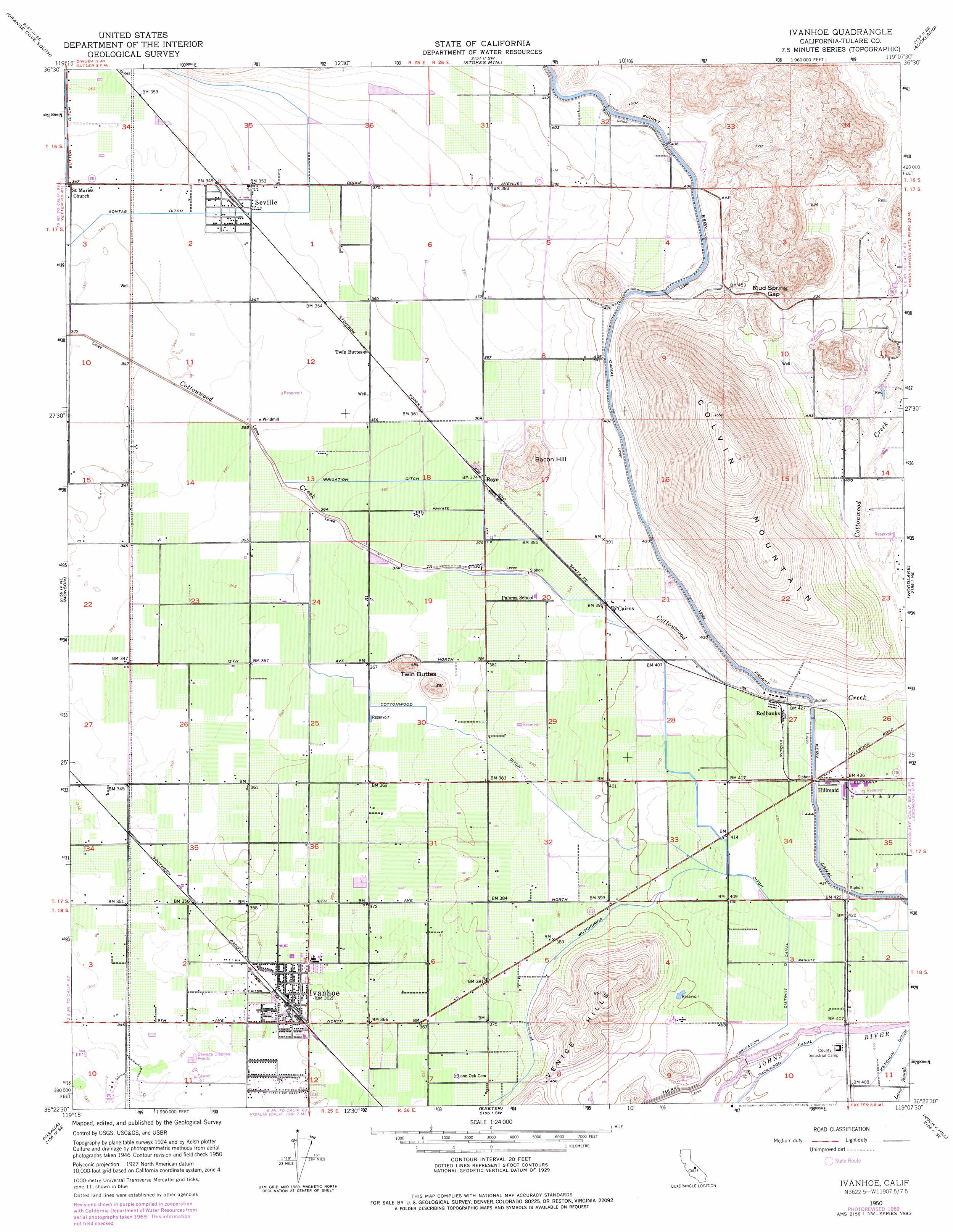
USGS Topo Quad 36119d2 - 1:24,000 scale
| Topo Map Name: | Ivanhoe |
| USGS Topo Quad ID: | 36119d2 |
| Print Size: | ca. 21 1/4" wide x 27" high |
| Southeast Coordinates: | 36.375° N latitude / 119.125° W longitude |
| Map Center Coordinates: | 36.4375° N latitude / 119.1875° W longitude |
| U.S. State: | CA |
| Filename: | o36119d2.jpg |
| Download Map JPG Image: | Ivanhoe topo map 1:24,000 scale |
| Map Type: | Topographic |
| Topo Series: | 7.5´ |
| Map Scale: | 1:24,000 |
| Source of Map Images: | United States Geological Survey (USGS) |
| Alternate Map Versions: |
Ivanhoe CA 1950, updated 1952 Download PDF Buy paper map Ivanhoe CA 1950, updated 1964 Download PDF Buy paper map Ivanhoe CA 1950, updated 1971 Download PDF Buy paper map Ivanhoe CA 1950, updated 1976 Download PDF Buy paper map Ivanhoe CA 2012 Download PDF Buy paper map Ivanhoe CA 2015 Download PDF Buy paper map |
1:24,000 Topo Quads surrounding Ivanhoe
Wahtoke |
Orange Cove North |
Tucker Mountain |
Miramonte |
General Grant Grove |
Reedley |
Orange Cove South |
Stokes Mountain |
Auckland |
Shadequarter Mountain |
Traver |
Monson |
Ivanhoe |
Woodlake |
Kaweah |
Goshen |
Visalia |
Exeter |
Rocky Hill |
Chickencoop Canyon |
Paige |
Tulare |
Cairns Corner |
Lindsay |
Frazier Valley |
> Back to 36119a1 at 1:100,000 scale
> Back to 36118a1 at 1:250,000 scale
> Back to U.S. Topo Maps home
Ivanhoe topo map: Gazetteer
Ivanhoe: Canals
Cottonwood Ditch elevation 116m 380′Sontag Ditch elevation 106m 347′
Tulare Irrigation District Canal elevation 124m 406′
Wutchumna Ditch elevation 121m 396′
Ivanhoe: Gaps
Mud Spring Gap elevation 157m 515′Ivanhoe: Populated Places
Hillmaid elevation 133m 436′Ivanhoe elevation 111m 364′
Rayo elevation 114m 374′
Redbanks elevation 130m 426′
Seville elevation 108m 354′
Twin Buttes elevation 110m 360′
Ivanhoe: Post Offices
Ivanhoe Post Office elevation 111m 364′Ivanhoe: Ridges
Colvin Mountain elevation 489m 1604′Ivanhoe: Summits
Bacon Hill elevation 192m 629′Twin Buttes elevation 192m 629′
Ivanhoe digital topo map on disk
Buy this Ivanhoe topo map showing relief, roads, GPS coordinates and other geographical features, as a high-resolution digital map file on DVD:
Southern Sierra Nevada, California & Southern Nevada
Buy digital topo maps: Southern Sierra Nevada, California & Southern Nevada