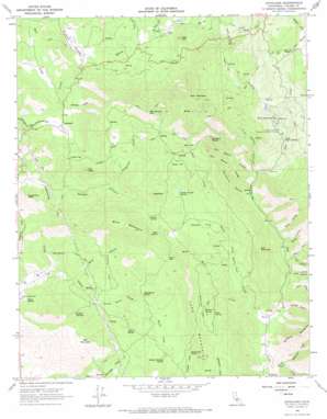
Auckland Topo Map California
To zoom in, hover over the map of Auckland
USGS Topo Quad 36119e1 - 1:24,000 scale
| Topo Map Name: | Auckland |
| USGS Topo Quad ID: | 36119e1 |
| Print Size: | ca. 21 1/4" wide x 27" high |
| Southeast Coordinates: | 36.5° N latitude / 119° W longitude |
| Map Center Coordinates: | 36.5625° N latitude / 119.0625° W longitude |
| U.S. State: | CA |
| Filename: | o36119e1.jpg |
| Download Map JPG Image: | Auckland topo map 1:24,000 scale |
| Map Type: | Topographic |
| Topo Series: | 7.5´ |
| Map Scale: | 1:24,000 |
| Source of Map Images: | United States Geological Survey (USGS) |
| Alternate Map Versions: |
Auckland CA 1966, updated 1967 Download PDF Buy paper map Auckland CA 1966, updated 1967 Download PDF Buy paper map Auckland CA 2012 Download PDF Buy paper map Auckland CA 2015 Download PDF Buy paper map |
1:24,000 Topo Quads surrounding Auckland
> Back to 36119e1 at 1:100,000 scale
> Back to 36118a1 at 1:250,000 scale
> Back to U.S. Topo Maps home
Auckland topo map: Gazetteer
Auckland: Basins
Collier Cove elevation 389m 1276′Auckland: Flats
Adams Flat elevation 569m 1866′Bear Flat elevation 787m 2582′
Brown Flat elevation 700m 2296′
Coyote Flat elevation 535m 1755′
Francis Flat elevation 417m 1368′
McClure Flat elevation 619m 2030′
Murry Flat elevation 413m 1354′
Pippin Flat elevation 911m 2988′
Quail Flat elevation 561m 1840′
Rancheria Flat elevation 377m 1236′
Auckland: Gaps
Adams Gap elevation 655m 2148′Auckland: Populated Places
Auckland elevation 390m 1279′Ellis Place elevation 268m 879′
Auckland: Ridges
Bill Moore Ridge elevation 684m 2244′Long Mountain elevation 736m 2414′
Auckland: Springs
Chimney Spring elevation 606m 1988′Cold Sulphur Spring elevation 547m 1794′
Coon Spring elevation 545m 1788′
Double Trough Spring elevation 591m 1938′
Dudley Spring elevation 505m 1656′
Green Spring elevation 305m 1000′
House Spring elevation 200m 656′
Indian Painting Spring elevation 536m 1758′
Indian Spring elevation 520m 1706′
McClure Spring elevation 605m 1984′
Rattlesnake Spring elevation 575m 1886′
Rock Spring elevation 636m 2086′
Schoolhouse Spring elevation 544m 1784′
Warm Sulphur Spring elevation 626m 2053′
Auckland: Streams
Badger Creek elevation 781m 2562′Bear Creek elevation 255m 836′
Buckeye Creek elevation 403m 1322′
Bull Creek elevation 394m 1292′
Cedar Creek elevation 316m 1036′
East Fork Dry Creek elevation 233m 764′
Elder Creek elevation 287m 941′
Fly Creek elevation 292m 958′
Grapevine Creek elevation 417m 1368′
Indian Creek elevation 522m 1712′
Murry Creek elevation 407m 1335′
Murry Creek elevation 437m 1433′
Persian Creek elevation 498m 1633′
Rattlesnake Creek elevation 372m 1220′
Shadley Creek elevation 610m 2001′
Wagonshed Creek elevation 270m 885′
Auckland: Summits
Ash Spring Mountain elevation 1089m 3572′Bear Mountain elevation 1220m 4002′
Blue Mountain elevation 970m 3182′
Buzzard Roost elevation 900m 2952′
Ellis Mountain elevation 754m 2473′
Goat Hill elevation 723m 2372′
Grapevine Peak elevation 580m 1902′
Owl Peak elevation 732m 2401′
Red Mountain elevation 703m 2306′
Sugarloaf elevation 809m 2654′
Auckland: Valleys
Bill Moore Canyon elevation 416m 1364′Blue Canyon elevation 300m 984′
Buck Canyon elevation 337m 1105′
Clark Canyon elevation 287m 941′
Lion Canyon elevation 336m 1102′
Lucky Canyon elevation 303m 994′
Lucy Runyon Canyon elevation 416m 1364′
Marble Canyon elevation 329m 1079′
Mitchell Canyon elevation 267m 875′
Morgan Canyon elevation 304m 997′
Murry Gulch elevation 744m 2440′
Rancheria Canyon elevation 386m 1266′
Slickrock Canyon elevation 427m 1400′
Woolley Canyon elevation 557m 1827′
Auckland digital topo map on disk
Buy this Auckland topo map showing relief, roads, GPS coordinates and other geographical features, as a high-resolution digital map file on DVD:
Southern Sierra Nevada, California & Southern Nevada
Buy digital topo maps: Southern Sierra Nevada, California & Southern Nevada


