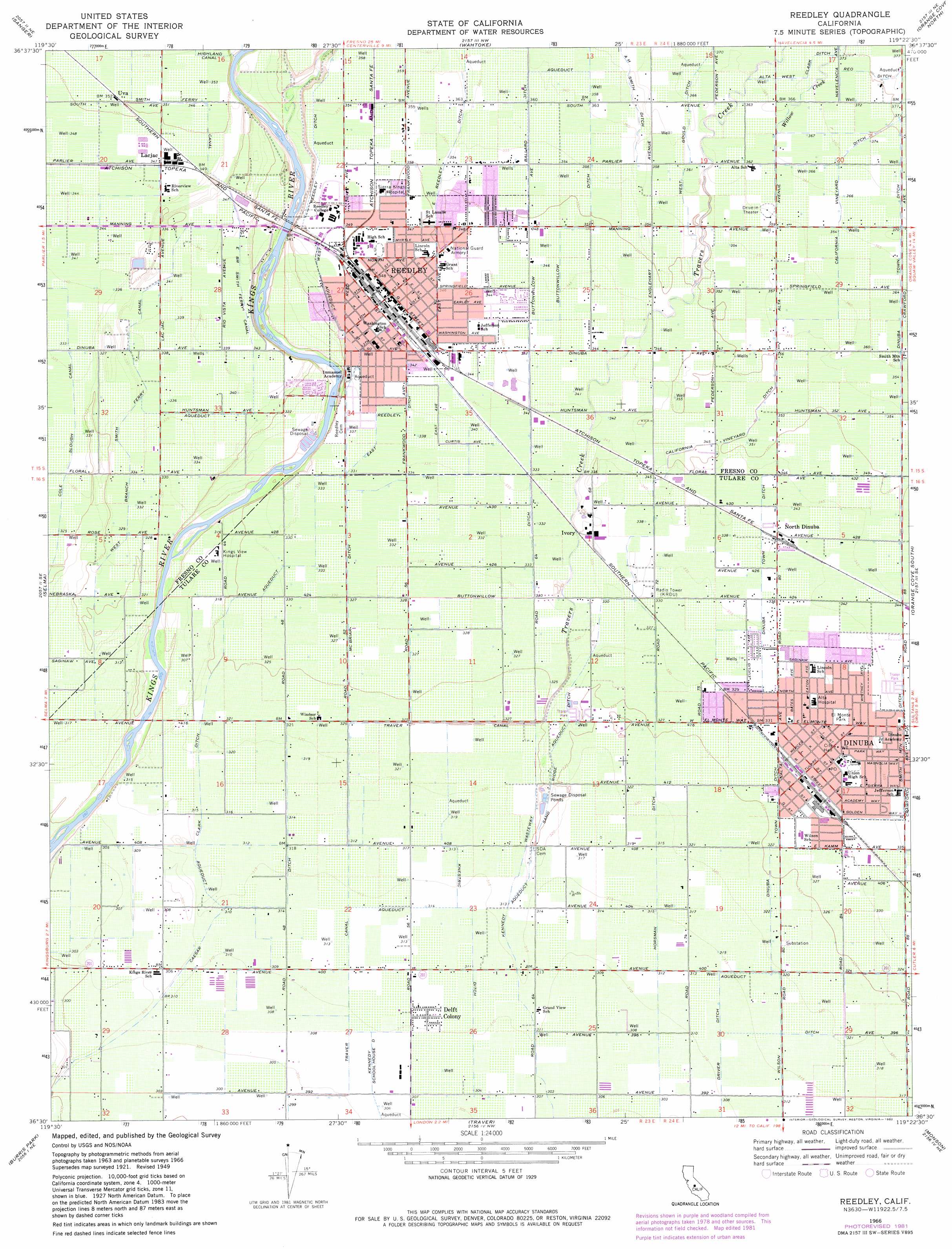
Reedley Topo Map California
To zoom in, hover over the map of Reedley
USGS Topo Quad 36119e4 - 1:24,000 scale
| Topo Map Name: | Reedley |
| USGS Topo Quad ID: | 36119e4 |
| Print Size: | ca. 21 1/4" wide x 27" high |
| Southeast Coordinates: | 36.5° N latitude / 119.375° W longitude |
| Map Center Coordinates: | 36.5625° N latitude / 119.4375° W longitude |
| U.S. State: | CA |
| Filename: | o36119e4.jpg |
| Download Map JPG Image: | Reedley topo map 1:24,000 scale |
| Map Type: | Topographic |
| Topo Series: | 7.5´ |
| Map Scale: | 1:24,000 |
| Source of Map Images: | United States Geological Survey (USGS) |
| Alternate Map Versions: |
Reedley CA 1949, updated 1958 Download PDF Buy paper map Reedley CA 1951 Download PDF Buy paper map Reedley CA 1966, updated 1967 Download PDF Buy paper map Reedley CA 1966, updated 1982 Download PDF Buy paper map Reedley CA 2012 Download PDF Buy paper map Reedley CA 2015 Download PDF Buy paper map |
1:24,000 Topo Quads surrounding Reedley
Clovis |
Round Mountain |
Piedra |
Pine Flat Dam |
Luckett Mountain |
Malaga |
Sanger |
Wahtoke |
Orange Cove North |
Tucker Mountain |
Conejo |
Selma |
Reedley |
Orange Cove South |
Stokes Mountain |
Laton |
Burris Park |
Traver |
Monson |
Ivanhoe |
Hanford |
Remnoy |
Goshen |
Visalia |
Exeter |
> Back to 36119e1 at 1:100,000 scale
> Back to 36118a1 at 1:250,000 scale
> Back to U.S. Topo Maps home
Reedley topo map: Gazetteer
Reedley: Airports
Kings River Community College Airport elevation 91m 298′Reedley: Beaches
Reedley Beach elevation 91m 298′Reedley: Canals
A H Smith Ditch elevation 114m 374′Buttonwillow Ditch elevation 110m 360′
California Vineyard Ditch elevation 112m 367′
Clark Ditch elevation 98m 321′
Cole Slough Canal elevation 102m 334′
Dinuba Town Ditch elevation 102m 334′
Driver Ditch elevation 96m 314′
East Branch Smith Ferry Canal elevation 106m 347′
East Reedley Ditch elevation 112m 367′
Horsman Ditch elevation 98m 321′
Kennedy Wasteway elevation 98m 321′
Knestric Ditch elevation 96m 314′
McBriar Ditch elevation 102m 334′
Smith Ferry Canal elevation 108m 354′
West Branch Smith Ferry Canal elevation 103m 337′
West Reedley Ditch elevation 108m 354′
Reedley: Crossings
Smiths Ferry (historical) elevation 107m 351′Reedley: Parks
Camacho Park elevation 107m 351′College Park elevation 101m 331′
Cricket Hollow Park elevation 94m 308′
El Monte Elementary School elevation 102m 334′
Monument Hill Park elevation 94m 308′
Pioneer Park elevation 106m 347′
Roosevelt Park elevation 103m 337′
Reedley: Populated Places
Delft Colony elevation 95m 311′Dinuba elevation 102m 334′
Enson elevation 106m 347′
Ivory elevation 104m 341′
Lacjac elevation 106m 347′
North Dinuba elevation 105m 344′
Reedley elevation 106m 347′
Uva elevation 108m 354′
Reedley: Post Offices
Dinuba Post Office elevation 101m 331′Reedley Post Office elevation 106m 347′
Reedley: Streams
Travers Creek elevation 100m 328′Wahtoke Creek elevation 95m 311′
Willow Creek elevation 113m 370′
Reedley digital topo map on disk
Buy this Reedley topo map showing relief, roads, GPS coordinates and other geographical features, as a high-resolution digital map file on DVD:
Southern Sierra Nevada, California & Southern Nevada
Buy digital topo maps: Southern Sierra Nevada, California & Southern Nevada