Ventana Cones Topo Map California
To zoom in, hover over the map of Ventana Cones
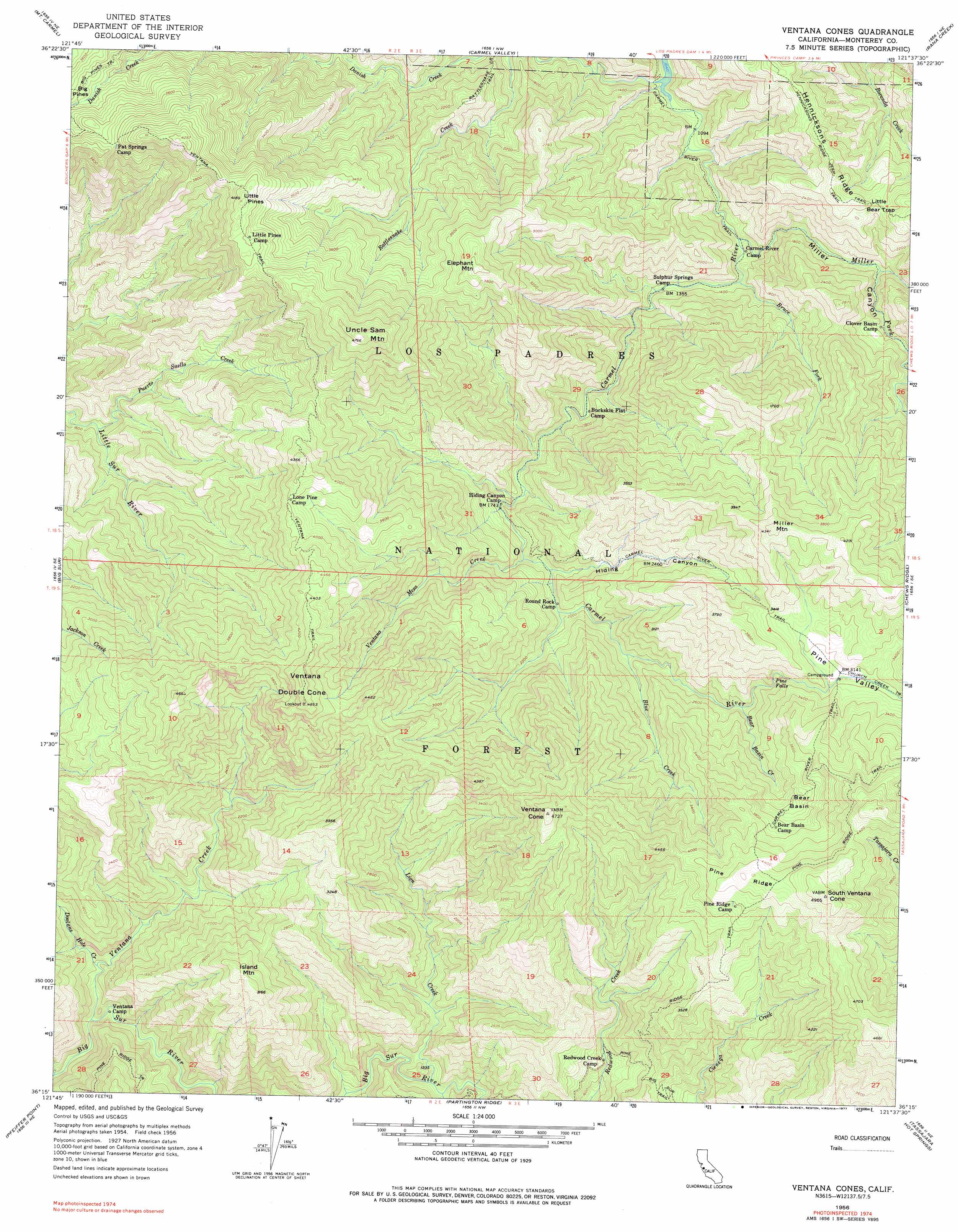
USGS Topo Quad 36121c6 - 1:24,000 scale
| Topo Map Name: | Ventana Cones |
| USGS Topo Quad ID: | 36121c6 |
| Print Size: | ca. 21 1/4" wide x 27" high |
| Southeast Coordinates: | 36.25° N latitude / 121.625° W longitude |
| Map Center Coordinates: | 36.3125° N latitude / 121.6875° W longitude |
| U.S. State: | CA |
| Filename: | o36121c6.jpg |
| Download Map JPG Image: | Ventana Cones topo map 1:24,000 scale |
| Map Type: | Topographic |
| Topo Series: | 7.5´ |
| Map Scale: | 1:24,000 |
| Source of Map Images: | United States Geological Survey (USGS) |
| Alternate Map Versions: |
Ventana Cones CA 1956, updated 1958 Download PDF Buy paper map Ventana Cones CA 1956, updated 1963 Download PDF Buy paper map Ventana Cones CA 1956, updated 1971 Download PDF Buy paper map Ventana Cones CA 1956, updated 1977 Download PDF Buy paper map Ventana Cones CA 1956, updated 1977 Download PDF Buy paper map Ventana Cones CA 1995, updated 2000 Download PDF Buy paper map Ventana Cones CA 2012 Download PDF Buy paper map Ventana Cones CA 2015 Download PDF Buy paper map |
| FStopo: | US Forest Service topo Ventana Cones is available: Download FStopo PDF Download FStopo TIF |
1:24,000 Topo Quads surrounding Ventana Cones
Monterey |
Seaside |
Spreckels |
Chualar |
Gonzales |
Soberanes Point |
Mount Carmel |
Carmel Valley |
Rana Creek |
Palo Escrito Peak |
Point Sur |
Big Sur |
Ventana Cones |
Chews Ridge |
Sycamore Flat |
Pfeiffer Point |
Partington Ridge |
Tassajara Hot Springs |
Junipero Serra Peak |
|
Lopez Point |
Cone Peak |
> Back to 36121a1 at 1:100,000 scale
> Back to 36120a1 at 1:250,000 scale
> Back to U.S. Topo Maps home
Ventana Cones topo map: Gazetteer
Ventana Cones: Basins
Bear Basin elevation 1104m 3622′Pine Valley elevation 959m 3146′
Ventana Cones: Falls
Pine Falls elevation 850m 2788′Ventana Cones: Gaps
Little Bear Trap elevation 762m 2500′Ventana Cones: Ridges
Hennicksons Ridge elevation 824m 2703′Pine Ridge elevation 1406m 4612′
Ventana Cones: Springs
Sulphur Spring elevation 413m 1354′Ventana Cones: Streams
Bear Basin Creek elevation 740m 2427′Blue Creek elevation 632m 2073′
Bruce Fork elevation 385m 1263′
Danish Creek elevation 318m 1043′
Dolores Creek elevation 314m 1030′
Doolans Hole Creek elevation 238m 780′
Lion Creek elevation 326m 1069′
Miller Fork Carmel River elevation 372m 1220′
Puerto Suello Creek elevation 472m 1548′
Ventana Creek elevation 190m 623′
Ventana Mesa Creek elevation 558m 1830′
Ventana Cones: Summits
Elephant Mountain elevation 1200m 3937′Island Mountain elevation 956m 3136′
Little Pines elevation 1266m 4153′
Miller Mountain elevation 1319m 4327′
South Ventana Cone elevation 1517m 4977′
Uncle Sam Mountain elevation 1445m 4740′
Ventana Cone elevation 1434m 4704′
Ventana Double Cone elevation 1477m 4845′
Ventana Cones: Trails
Carmel River Trail elevation 329m 1079′Hennicksons Ridge Trail elevation 854m 2801′
Pine Ridge Trail elevation 1410m 4625′
Ventana Trail elevation 1236m 4055′
Ventana Cones: Valleys
Hiding Canyon elevation 585m 1919′Miller Canyon elevation 397m 1302′
Ventana Cones digital topo map on disk
Buy this Ventana Cones topo map showing relief, roads, GPS coordinates and other geographical features, as a high-resolution digital map file on DVD: