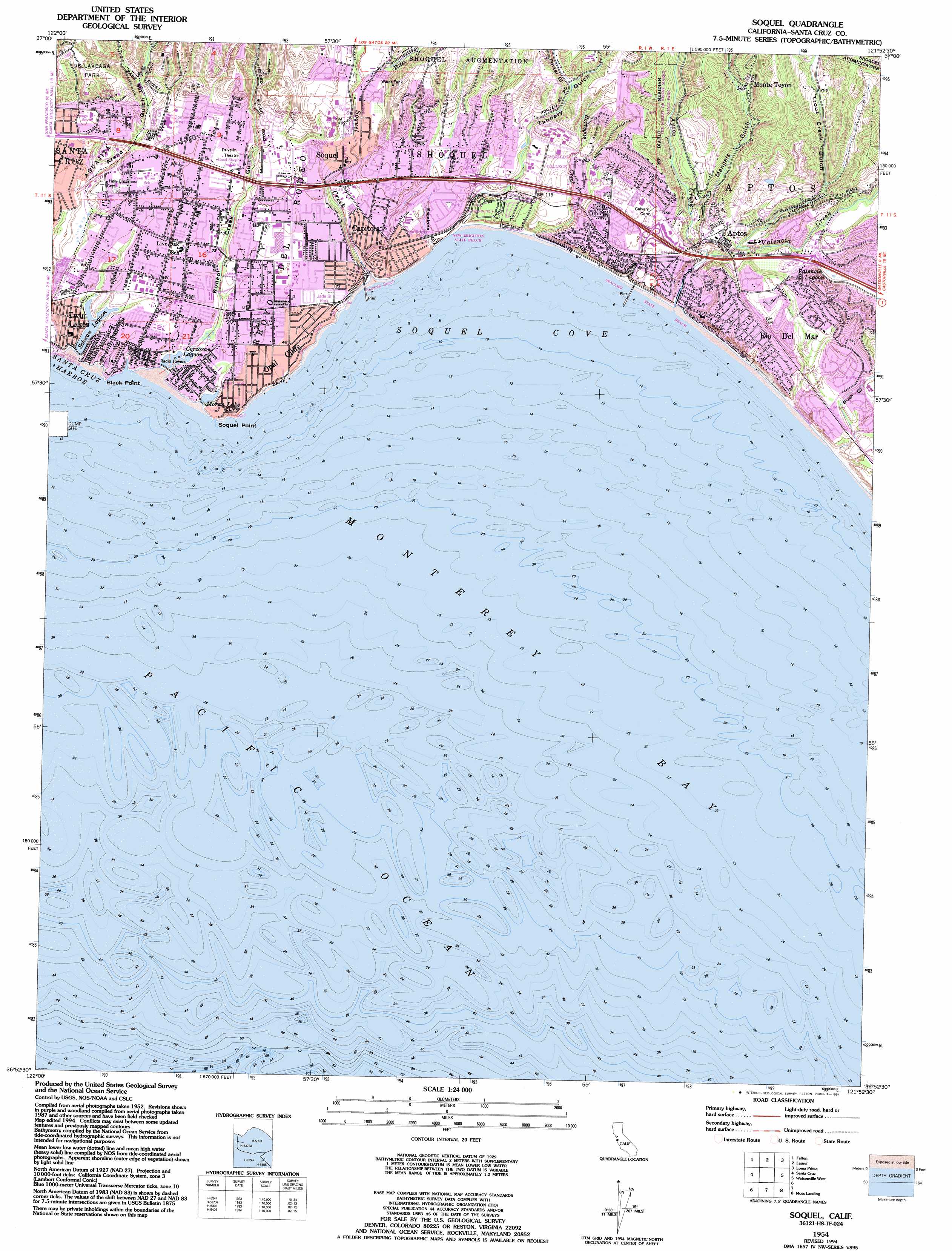
Soquel Topo Map California
To zoom in, hover over the map of Soquel
USGS Topo Quad 36121h8 - 1:24,000 scale
| Topo Map Name: | Soquel |
| USGS Topo Quad ID: | 36121h8 |
| Print Size: | ca. 21 1/4" wide x 27" high |
| Southeast Coordinates: | 36.875° N latitude / 121.875° W longitude |
| Map Center Coordinates: | 36.9375° N latitude / 121.9375° W longitude |
| U.S. State: | CA |
| Filename: | o36121h8.jpg |
| Download Map JPG Image: | Soquel topo map 1:24,000 scale |
| Map Type: | Topographic |
| Topo Series: | 7.5´ |
| Map Scale: | 1:24,000 |
| Source of Map Images: | United States Geological Survey (USGS) |
| Alternate Map Versions: |
Soquel CA 1954, updated 1955 Download PDF Buy paper map Soquel CA 1954, updated 1965 Download PDF Buy paper map Soquel CA 1954, updated 1969 Download PDF Buy paper map Soquel CA 1954, updated 1981 Download PDF Buy paper map Soquel CA 1954, updated 1994 Download PDF Buy paper map Soquel CA 2012 Download PDF Buy paper map Soquel CA 2015 Download PDF Buy paper map |
1:24,000 Topo Quads surrounding Soquel
Big Basin |
Castle Rock Ridge |
Los Gatos |
Santa Teresa Hills |
Morgan Hill |
Davenport |
Felton |
Laurel |
Loma Prieta |
Mount Madonna |
Santa Cruz |
Soquel |
Watsonville West |
Watsonville East |
|
Moss Landing |
Prunedale |
|||
Marina |
Salinas |
> Back to 36121e1 at 1:100,000 scale
> Back to 36120a1 at 1:250,000 scale
> Back to U.S. Topo Maps home
Soquel topo map: Gazetteer
Soquel: Airports
Capitola Airport (historical) elevation 35m 114′Dominican Santa Cruz Hospital Heliport elevation 35m 114′
Soquel: Bays
Soquel Cove elevation 0m 0′Sunny Cove elevation 1m 3′
Soquel: Beaches
Capitola Beach elevation 2m 6′Hooper Beach elevation 14m 45′
Lincoln Beach elevation 1m 3′
Moran Lake Beach elevation 2m 6′
Potbelly Beach elevation 2m 6′
Rio Del Mar Beach elevation 2m 6′
Soquel: Capes
Black Point elevation 8m 26′Pleasure Point elevation 4m 13′
Soquel Point elevation 1m 3′
Soquel: Cliffs
Capitola Bluffs elevation 14m 45′Soquel: Lakes
Bonita Lagoon elevation 1m 3′Corcoran Lagoon elevation 0m 0′
Moran Lake elevation 0m 0′
Schwan Lagoon elevation 16m 52′
Soquel: Parks
Aptos Village Park elevation 40m 131′Brommer Park elevation 19m 62′
Capitola State Beach elevation 2m 6′
Coffee Lane Park elevation 26m 85′
De Laveaga Park elevation 93m 305′
Fourtyfirst Avenue County Park elevation 11m 36′
Jade Street Park elevation 16m 52′
Lions Park elevation 9m 29′
Moran Lake Park elevation 0m 0′
New Brighton State Beach elevation 3m 9′
Old Riverview Historic District elevation 7m 22′
Perry Park elevation 13m 42′
Pleasure Point Beach County Park elevation 4m 13′
Rockview Drive County Park elevation 7m 22′
Seacliff State Beach elevation 3m 9′
Six Sisters-Lawn Way Historic District elevation 5m 16′
Sunny Cove Beach County Park elevation 7m 22′
The Forest of Nisene Marks State Park elevation 50m 164′
Thirteenth Avenue County Park elevation 6m 19′
Twelfth Avenue County Park elevation 4m 13′
Twentyfirst Avenue County Park elevation 2m 6′
Twin Lakes State Beach elevation 4m 13′
Soquel: Populated Places
Alimur Park Mobile Home Park elevation 38m 124′Aptos elevation 33m 108′
Bell Harbor Mobile Home Park elevation 9m 29′
Brookvale Terrace Mobile Home Park elevation 36m 118′
Cabrillo Mobile Home Park elevation 18m 59′
Capitola elevation 4m 13′
Castle Mobile Estates elevation 17m 55′
Cliftwood Mobile Home Park elevation 44m 144′
Country Villa Estates Mobile Home Park elevation 37m 121′
Farley (historical) elevation 35m 114′
Live Oak elevation 32m 104′
Loma Vista Mobile Home Park elevation 29m 95′
Monte Toyon elevation 82m 269′
New Brighton (historical) elevation 37m 121′
Ocean Breeze Mobile Home Park elevation 13m 42′
Old Mill Park Mobile Home Park elevation 12m 39′
Opal Cliff Park Mobile Home Park elevation 16m 52′
Opal Cliffs elevation 14m 45′
Orchard Lane Mobile Home Park elevation 39m 127′
Rio Del Mar elevation 44m 144′
Seacliff (historical) elevation 33m 108′
Shangri La Estates elevation 17m 55′
Snug Harbor Mobile Home Park elevation 9m 29′
Soquel elevation 10m 32′
Surf and Sand Mobile Home Park elevation 10m 32′
Tony Ziro Mobile Living Mobile Home Park elevation 12m 39′
Tradewinds Mobile Home Park elevation 20m 65′
Trailer Haven elevation 13m 42′
Twin Lakes elevation 16m 52′
Soquel: Post Offices
Soquel Post Office elevation 10m 32′Soquel: Streams
Aptos Creek elevation 2m 6′Bates Creek elevation 15m 49′
Borregas Creek elevation 4m 13′
Soquel Creek elevation 2m 6′
Trout Creek elevation 14m 45′
Valencia Creek elevation 17m 55′
Soquel: Swamps
Arana Marsh elevation 3m 9′Valencia Lagoon elevation 36m 118′
Soquel: Trails
Buggy Trail elevation 67m 219′Terrace Trail elevation 35m 114′
Soquel: Valleys
Arana Gulch elevation 8m 26′Bush Gulch elevation 5m 16′
Escalona Gulch elevation 0m 0′
Mangels Gulch elevation 17m 55′
Porter Gulch elevation 78m 255′
Rodeo Creek Gulch elevation 2m 6′
Tannery Gulch elevation 4m 13′
Trout Creek Gulch elevation 7m 22′
Soquel: Woods
Pringle Grove elevation 16m 52′Soquel digital topo map on disk
Buy this Soquel topo map showing relief, roads, GPS coordinates and other geographical features, as a high-resolution digital map file on DVD: