Cobb Island Topo Map Virginia
To zoom in, hover over the map of Cobb Island
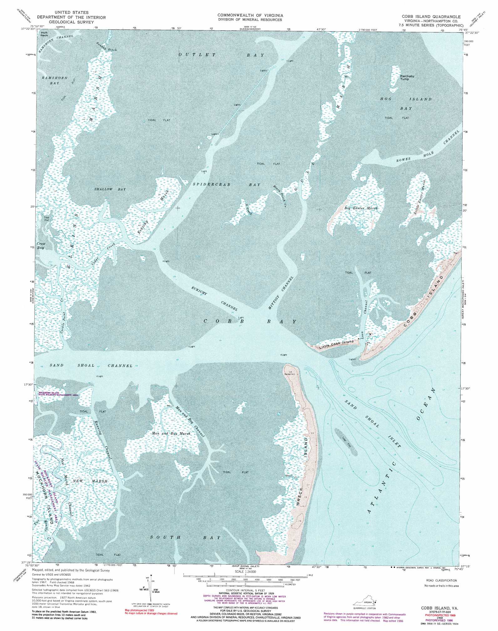
USGS Topo Quad 37075c7 - 1:24,000 scale
| Topo Map Name: | Cobb Island |
| USGS Topo Quad ID: | 37075c7 |
| Print Size: | ca. 21 1/4" wide x 27" high |
| Southeast Coordinates: | 37.25° N latitude / 75.75° W longitude |
| Map Center Coordinates: | 37.3125° N latitude / 75.8125° W longitude |
| U.S. State: | VA |
| Filename: | o37075c7.jpg |
| Download Map JPG Image: | Cobb Island topo map 1:24,000 scale |
| Map Type: | Topographic |
| Topo Series: | 7.5´ |
| Map Scale: | 1:24,000 |
| Source of Map Images: | United States Geological Survey (USGS) |
| Alternate Map Versions: |
Cobb Island VA 1942, updated 1952 Download PDF Buy paper map Cobb Island VA 1968, updated 1971 Download PDF Buy paper map Cobb Island VA 1968, updated 1984 Download PDF Buy paper map Cobb Island VA 1968, updated 1986 Download PDF Buy paper map Cobb Island VA 1968, updated 1991 Download PDF Buy paper map Cobb Island VA 1977, updated 1982 Download PDF Buy paper map Cobb Island VA 2011 Download PDF Buy paper map Cobb Island VA 2013 Download PDF Buy paper map Cobb Island VA 2016 Download PDF Buy paper map |
1:24,000 Topo Quads surrounding Cobb Island
West Of Jamesville |
Jamesville |
Exmore |
Wachapreague |
|
West Of Franktown |
Franktown |
Nassawadox |
Quinby Inlet |
|
Cape Charles |
Cheriton |
Cobb Island |
Great Machipongo Inlet |
|
Elliotts Creek |
Townsend |
Ship Shoal Inlet |
||
Chesapeake Channel |
Fishermans Island |
> Back to 37075a1 at 1:100,000 scale
> Back to 37074a1 at 1:250,000 scale
> Back to U.S. Topo Maps home
Cobb Island topo map: Gazetteer
Cobb Island: Bays
Cobb Bay elevation 0m 0′Outlet Bay elevation 0m 0′
Sand Shoal Inlet elevation 0m 0′
Shallow Bay elevation 0m 0′
Spidercrab Bay elevation 0m 0′
Cobb Island: Canals
Sunday Ditch elevation 0m 0′Cobb Island: Channels
Black Perch Creek elevation 1m 3′Cedar Creek elevation 0m 0′
Cockle Point Creek elevation 0m 0′
Eckichy Channel elevation 0m 0′
Loon Channel elevation 0m 0′
Man and Boy Channel elevation 0m 0′
Mittigy Channel elevation 0m 0′
New Marsh Channel elevation 0m 0′
Northeast Channel elevation 0m 0′
Rowes Hole Channel elevation 0m 0′
Running Channel elevation 0m 0′
Sand Creek elevation 1m 3′
Sand Shoal Channel elevation 0m 0′
South Channel elevation 0m 0′
Southeast Channel elevation 0m 0′
Cobb Island: Islands
Little Cobb Island elevation 1m 3′Parchaby Tump elevation 0m 0′
Wreck Island elevation 1m 3′
Cobb Island: Streams
Shell Creek elevation 1m 3′Two Mouths Creek elevation 0m 0′
Cobb Island: Swamps
Big Easter Marsh elevation 1m 3′Eckichy Marsh elevation 0m 0′
Elkins Marsh elevation 1m 3′
Gull Marsh elevation 0m 0′
Little Easter Marsh elevation 1m 3′
Man and Boy Marsh elevation 1m 3′
New Marsh elevation 1m 3′
Cobb Island digital topo map on disk
Buy this Cobb Island topo map showing relief, roads, GPS coordinates and other geographical features, as a high-resolution digital map file on DVD:
Atlantic Coast (NY, NJ, PA, DE, MD, VA, NC)
Buy digital topo maps: Atlantic Coast (NY, NJ, PA, DE, MD, VA, NC)
 map DVD")