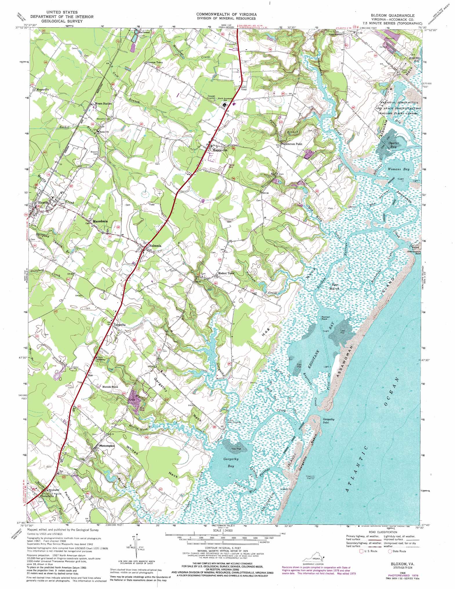
Bloxom Topo Map Virginia
To zoom in, hover over the map of Bloxom
USGS Topo Quad 37075g5 - 1:24,000 scale
| Topo Map Name: | Bloxom |
| USGS Topo Quad ID: | 37075g5 |
| Print Size: | ca. 21 1/4" wide x 27" high |
| Southeast Coordinates: | 37.75° N latitude / 75.5° W longitude |
| Map Center Coordinates: | 37.8125° N latitude / 75.5625° W longitude |
| U.S. State: | VA |
| Filename: | o37075g5.jpg |
| Download Map JPG Image: | Bloxom topo map 1:24,000 scale |
| Map Type: | Topographic |
| Topo Series: | 7.5´ |
| Map Scale: | 1:24,000 |
| Source of Map Images: | United States Geological Survey (USGS) |
| Alternate Map Versions: |
Mappsville VA 1942, updated 1962 Download PDF Buy paper map Bloxom VA 1968, updated 1971 Download PDF Buy paper map Bloxom VA 1968, updated 1979 Download PDF Buy paper map Bloxom VA 1968, updated 1980 Download PDF Buy paper map Bloxom VA 1968, updated 1990 Download PDF Buy paper map Bloxom VA 2011 Download PDF Buy paper map Bloxom VA 2013 Download PDF Buy paper map Bloxom VA 2016 Download PDF Buy paper map |
1:24,000 Topo Quads surrounding Bloxom
Marion |
Kingston |
Pocomoke City |
Girdletree |
Boxiron |
Crisfield |
Saxis |
Hallwood |
Chincoteague West |
Chincoteague East |
Chesconessex |
Parksley |
Bloxom |
Wallops Island |
|
Pungoteague |
Accomac |
Metompkin Inlet |
||
Exmore |
Wachapreague |
> Back to 37075e1 at 1:100,000 scale
> Back to 37074a1 at 1:250,000 scale
> Back to U.S. Topo Maps home
Bloxom topo map: Gazetteer
Bloxom: Bays
Assawoman Inlet elevation 0m 0′Gargathy Bay elevation 0m 0′
Gargathy Inlet elevation 3m 9′
Kegotank Bay elevation 0m 0′
Oyster Bay elevation 0m 0′
Womans Bay elevation 0m 0′
Bloxom: Beaches
Gargathy Beach elevation 1m 3′Bloxom: Capes
Arbuckle Neck elevation 1m 3′Gargathy Neck elevation 5m 16′
Hog Neck elevation 2m 6′
Whites Neck elevation 4m 13′
Bloxom: Dams
Bundick Creek Dam elevation 3m 9′Bloxom: Guts
Big Gut elevation 2m 6′Dr Jack Gut elevation 1m 3′
Mud Narrows elevation 1m 3′
Northam Narrows elevation -8m -27′
Wire Passage elevation -7m -23′
Bloxom: Islands
Assawoman Island elevation 0m 0′Metompkin Islands elevation 1m 3′
Roman Rock elevation 0m 0′
Bloxom: Parks
Accomack Wayside elevation 6m 19′Bloxom: Populated Places
Bloxom elevation 7m 22′Centerville elevation 10m 32′
Gargatha elevation 15m 49′
Groton Town elevation 9m 29′
Macedonia elevation 12m 39′
Mappsville elevation 15m 49′
Mears Station elevation 6m 19′
Mearsville elevation 2m 6′
Metompkin elevation 9m 29′
Modest Town elevation 10m 32′
Mutton Hunk elevation 12m 39′
Nelsonia elevation 15m 49′
Persimmon Point elevation 11m 36′
Rue elevation 14m 45′
South Point elevation 4m 13′
Bloxom: Post Offices
Bloxom Post Office elevation 7m 22′Mappsville Post Office elevation 14m 45′
Mears Post Office elevation 6m 19′
Nelsonia Post Office elevation 15m 49′
Bloxom: Reservoirs
Bundick Pond elevation 3m 9′Bloxom: Streams
Arbuckle Creek elevation -2m -7′Assawoman Creek elevation 1m 3′
Cutoff Creek elevation 10m 32′
First Creek elevation 0m 0′
Gargathy Creek elevation 1m 3′
Hog Creek elevation 0m 0′
Hog Neck Creek elevation 0m 0′
Houseboat Creek elevation 0m 0′
Kegotank Creek elevation 0m 0′
Lucas Creek elevation 0m 0′
Mutton Hunk Branch elevation 0m 0′
Northam Creek elevation 0m 0′
Pettit Branch elevation 0m 0′
Shipping Creek elevation 2m 6′
Trout Creek elevation 0m 0′
Whites Creek elevation 3m 9′
Bloxom: Swamps
Egg Marsh elevation 1m 3′Bloxom digital topo map on disk
Buy this Bloxom topo map showing relief, roads, GPS coordinates and other geographical features, as a high-resolution digital map file on DVD:
Atlantic Coast (NY, NJ, PA, DE, MD, VA, NC)
Buy digital topo maps: Atlantic Coast (NY, NJ, PA, DE, MD, VA, NC)
 map DVD")