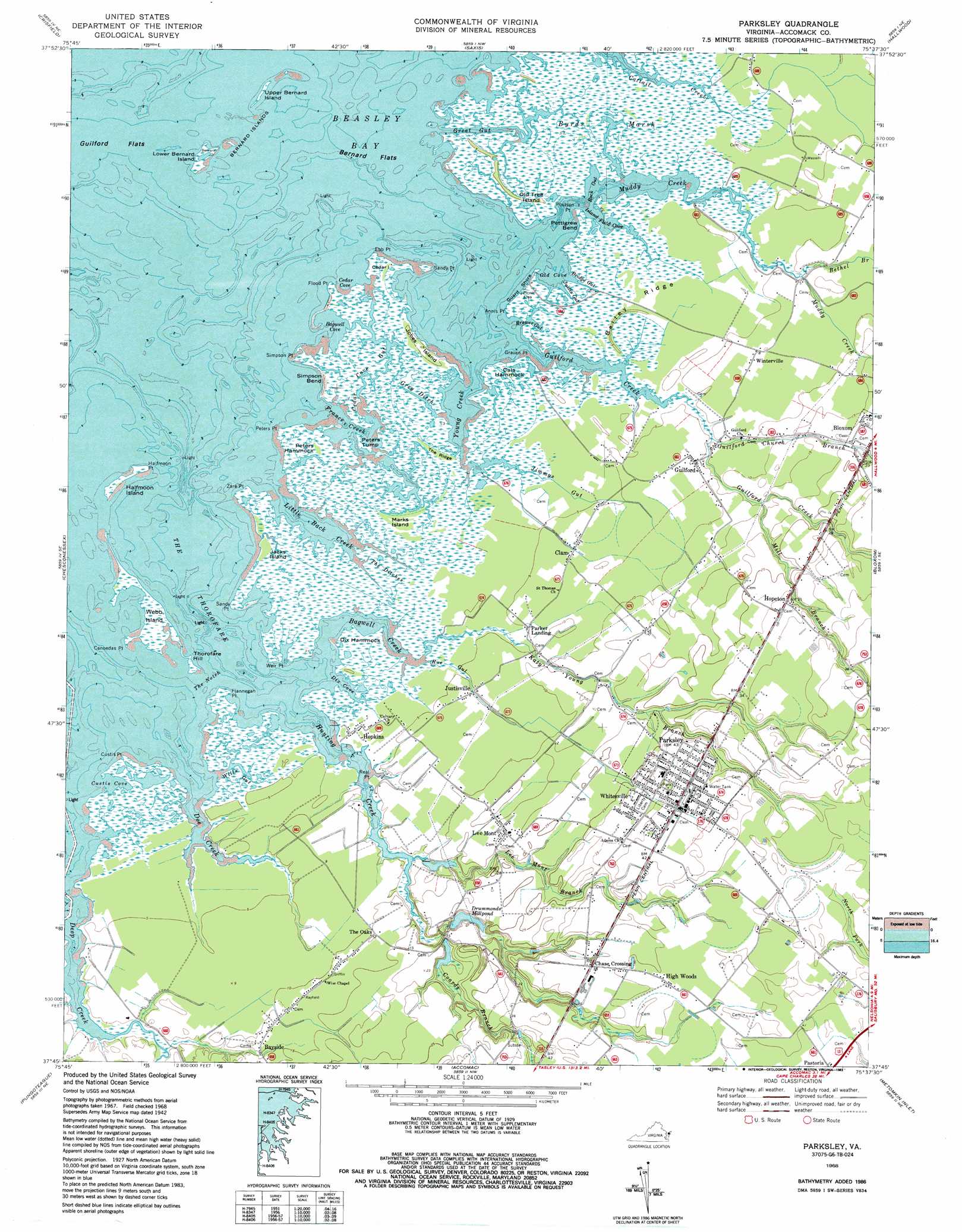
Parksley Topo Map Virginia
To zoom in, hover over the map of Parksley
USGS Topo Quad 37075g6 - 1:24,000 scale
| Topo Map Name: | Parksley |
| USGS Topo Quad ID: | 37075g6 |
| Print Size: | ca. 21 1/4" wide x 27" high |
| Southeast Coordinates: | 37.75° N latitude / 75.625° W longitude |
| Map Center Coordinates: | 37.8125° N latitude / 75.6875° W longitude |
| U.S. State: | VA |
| Filename: | o37075g6.jpg |
| Download Map JPG Image: | Parksley topo map 1:24,000 scale |
| Map Type: | Topographic |
| Topo Series: | 7.5´ |
| Map Scale: | 1:24,000 |
| Source of Map Images: | United States Geological Survey (USGS) |
| Alternate Map Versions: |
Parksley VA 1942, updated 1962 Download PDF Buy paper map Parksley VA 1968, updated 1971 Download PDF Buy paper map Parksley VA 1968, updated 1984 Download PDF Buy paper map Parksley VA 1968, updated 1987 Download PDF Buy paper map Parksley VA 1968, updated 1987 Download PDF Buy paper map Parksley VA 2011 Download PDF Buy paper map Parksley VA 2013 Download PDF Buy paper map Parksley VA 2016 Download PDF Buy paper map |
1:24,000 Topo Quads surrounding Parksley
Terrapin Sand Point |
Marion |
Kingston |
Pocomoke City |
Girdletree |
Great Fox Island |
Crisfield |
Saxis |
Hallwood |
Chincoteague West |
Tangier Island |
Chesconessex |
Parksley |
Bloxom |
Wallops Island |
Nandua Creek |
Pungoteague |
Accomac |
Metompkin Inlet |
|
Jamesville |
Exmore |
Wachapreague |
> Back to 37075e1 at 1:100,000 scale
> Back to 37074a1 at 1:250,000 scale
> Back to U.S. Topo Maps home
Parksley topo map: Gazetteer
Parksley: Bars
Bernard Flats elevation 0m 0′Parksley: Bays
Bagwell Cove elevation 0m 0′Beasley Bay elevation 0m 0′
Cals Hammock elevation 1m 3′
Cedar Cove elevation 0m 0′
Custis Cove elevation 0m 0′
Dix Cove elevation 0m 0′
Island Field Cove elevation 0m 0′
Old Cove elevation 0m 0′
Parksley: Beaches
Guard Shore elevation 1m 3′Parksley: Bends
Pettigrew Bend elevation 1m 3′Simpson Bend elevation 1m 3′
Parksley: Canals
Grey Ditch elevation 1m 3′Parksley: Capes
Annis Point elevation 1m 3′Canoedas Point elevation 1m 3′
Custis Point elevation 0m 0′
Ebb Point elevation 0m 0′
Flannegan Point elevation 0m 0′
Flood Point elevation 0m 0′
Graven Point elevation 0m 0′
Halfmoon Point elevation 0m 0′
Peters Point elevation 0m 0′
Poulson Point elevation 0m 0′
Real Point elevation 1m 3′
Sandy Point elevation 0m 0′
Sandy Point elevation 1m 3′
Simpson Point elevation 1m 3′
Weir Point elevation 1m 3′
Zare Point elevation 0m 0′
Parksley: Channels
The Thorofare elevation 0m 0′Parksley: Dams
Drummonds Millpond Dam elevation 2m 6′Parksley: Guts
Brewer Gut elevation 0m 0′Bridge Gut elevation 1m 3′
Cedar Cove Gut elevation 0m 0′
Great Gut elevation 1m 3′
Jimmys Gut elevation 1m 3′
Justis Gut elevation 1m 3′
Rock Gut elevation 0m 0′
Rue Gut elevation 1m 3′
Wills Gut elevation 0m 0′
Parksley: Islands
Bernard Islands elevation 0m 0′Cedar Island elevation 1m 3′
Dix Hammock elevation 1m 3′
Halfmoon Island elevation 1m 3′
Jacks Island elevation 1m 3′
Jobes Island elevation 1m 3′
Lower Bernard Island elevation 1m 3′
Marks Island elevation 1m 3′
Old Tree Island elevation 1m 3′
Peters Hammock elevation 1m 3′
Peters Tump elevation 0m 0′
The Notch elevation 0m 0′
Thorofare Hill elevation 1m 3′
Upper Bernard Island elevation 0m 0′
Webb Island elevation 1m 3′
Parksley: Populated Places
Chase Crossing elevation 12m 39′Clam elevation 2m 6′
Guilford elevation 1m 3′
High Woods elevation 12m 39′
Hopeton elevation 9m 29′
Hopkins elevation 1m 3′
Justisville elevation 1m 3′
Lee Mont elevation 5m 16′
Parker Landing elevation 2m 6′
Parksley elevation 13m 42′
Whitesville elevation 9m 29′
Winterville elevation 2m 6′
Parksley: Post Offices
Lee Mont Post Office elevation 5m 16′Parksley elevation 13m 42′
Parksley: Reservoirs
Drummonds Millpond elevation 2m 6′Parksley: Ridges
Bailey Ridge elevation 1m 3′The Ridge elevation 1m 3′
Parksley: Streams
Bagwell Creek elevation 0m 0′Bethel Branch elevation 1m 3′
Coards Branch elevation 1m 3′
Doe Creek elevation 0m 0′
France Creek elevation 0m 0′
Guilford Church Branch elevation 1m 3′
Guilford Creek elevation 0m 0′
Hunting Creek elevation 0m 0′
Katy Young Branch elevation 1m 3′
Lee Mont Branch elevation 1m 3′
Little Back Creek elevation 0m 0′
Mill Branch elevation 3m 9′
Muddy Creek elevation 0m 0′
Young Creek elevation 0m 0′
Parksley: Swamps
Byrds Marsh elevation 0m 0′The Ditches elevation 1m 3′
Parksley digital topo map on disk
Buy this Parksley topo map showing relief, roads, GPS coordinates and other geographical features, as a high-resolution digital map file on DVD:
Atlantic Coast (NY, NJ, PA, DE, MD, VA, NC)
Buy digital topo maps: Atlantic Coast (NY, NJ, PA, DE, MD, VA, NC)
 map DVD")