Chincoteague West Topo Map Virginia
To zoom in, hover over the map of Chincoteague West
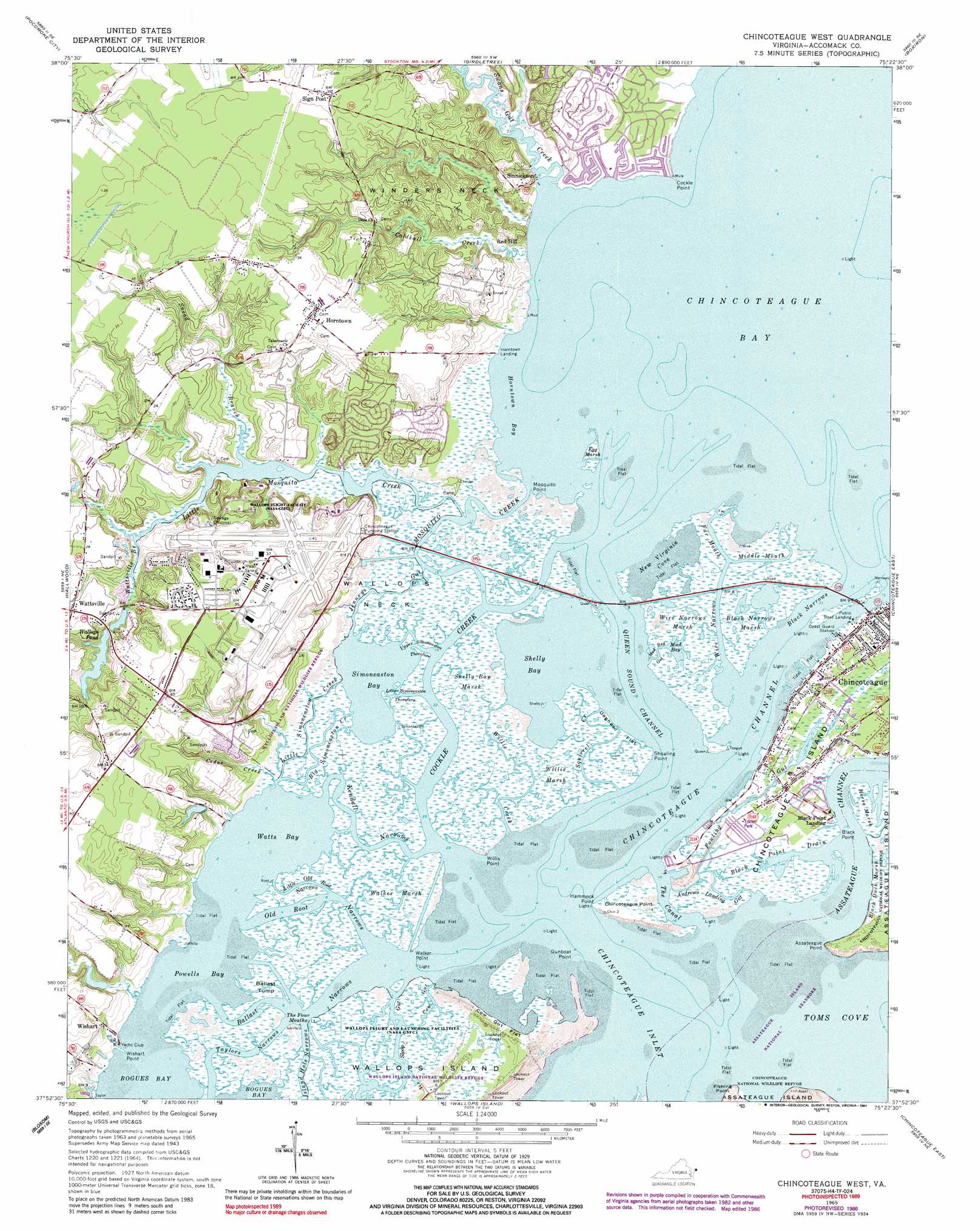
USGS Topo Quad 37075h4 - 1:24,000 scale
| Topo Map Name: | Chincoteague West |
| USGS Topo Quad ID: | 37075h4 |
| Print Size: | ca. 21 1/4" wide x 27" high |
| Southeast Coordinates: | 37.875° N latitude / 75.375° W longitude |
| Map Center Coordinates: | 37.9375° N latitude / 75.4375° W longitude |
| U.S. State: | VA |
| Filename: | o37075h4.jpg |
| Download Map JPG Image: | Chincoteague West topo map 1:24,000 scale |
| Map Type: | Topographic |
| Topo Series: | 7.5´ |
| Map Scale: | 1:24,000 |
| Source of Map Images: | United States Geological Survey (USGS) |
| Alternate Map Versions: |
Chincoteague West VA 1943, updated 1962 Download PDF Buy paper map Chincoteague West VA 1965 Download PDF Buy paper map Chincoteague West VA 1965, updated 1966 Download PDF Buy paper map Chincoteague West VA 1965, updated 1980 Download PDF Buy paper map Chincoteague West VA 1965, updated 1986 Download PDF Buy paper map Chincoteague West VA 1965, updated 1991 Download PDF Buy paper map Chincoteague West VA 2011 Download PDF Buy paper map Chincoteague West VA 2013 Download PDF Buy paper map Chincoteague West VA 2016 Download PDF Buy paper map |
1:24,000 Topo Quads surrounding Chincoteague West
Princess Anne |
Dividing Creek |
Snow Hill |
Public Landing |
Tingles Island |
Kingston |
Pocomoke City |
Girdletree |
Boxiron |
Whittington Point |
Saxis |
Hallwood |
Chincoteague West |
Chincoteague East |
|
Parksley |
Bloxom |
Wallops Island |
||
Accomac |
Metompkin Inlet |
> Back to 37075e1 at 1:100,000 scale
> Back to 37074a1 at 1:250,000 scale
> Back to U.S. Topo Maps home
Chincoteague West topo map: Gazetteer
Chincoteague West: Airports
Wallops Flight Facility Airport elevation 10m 32′Chincoteague West: Bays
Horntown Bay elevation 0m 0′Mud Bay elevation 0m 0′
New Virginia Cove elevation 0m 0′
Powells Bay elevation 0m 0′
Shelly Bay elevation 0m 0′
Simoneaston Bay elevation 0m 0′
The Four Mouths elevation 7m 22′
Watts Bay elevation 0m 0′
Chincoteague West: Capes
Assateague Point elevation 0m 0′Black Point elevation 1m 3′
Chincoteague Point elevation 1m 3′
Cockle Point elevation 0m 0′
Fishing Point elevation 0m 0′
Gunboat Point elevation 0m 0′
Hammock Point elevation 0m 0′
Mosquito Point elevation 1m 3′
Shoaling Point elevation 1m 3′
Walker Point elevation 0m 0′
Wallops Neck elevation 1m 3′
Willis Point elevation 0m 0′
Winders Neck elevation 6m 19′
Wishart Point elevation 1m 3′
Chincoteague West: Channels
Chincoteague Channel elevation 0m 0′Chincoteague Inlet elevation 0m 0′
Lower Simoneaston Thorofare elevation 0m 0′
Queen Sound Channel elevation 0m 0′
Upper Simoneaston Thorofare elevation 1m 3′
Chincoteague West: Dams
Wallops Pond Dam elevation 0m 0′Chincoteague West: Flats
Cow Gut Flat elevation 1m 3′Doghead Flat elevation 1m 3′
Chincoteague West: Guts
Andrews Landing Gut elevation 1m 3′Ballast Narrows elevation -3m -10′
Black Narrows elevation 1m 3′
Black Point Drain elevation 0m 0′
Cow Gut elevation 1m 3′
Far Mouth elevation 0m 0′
Fowling Gut elevation 1m 3′
Island Hole Narrows elevation 0m 0′
Jenneys Gut elevation 1m 3′
Kendall Narrows elevation 0m 0′
Little Old Root Narrows elevation 0m 0′
Middle Mouth elevation 1m 3′
Mud Bay Gut elevation 0m 0′
Old Root Narrows elevation -9m -30′
Oyster Gut elevation 1m 3′
Sloop Gut elevation 0m 0′
Taylors Narrows elevation 1m 3′
The Canal elevation 0m 0′
Wire Narrows elevation -2m -7′
Chincoteague West: Islands
Ballast Tump elevation 1m 3′Chincoteague West: Parks
Wallops Island National Wildlife Refuge elevation 1m 3′Chincoteague West: Populated Places
Black Point Landing elevation 1m 3′Captains Cove elevation 5m 16′
Chincoteague elevation 1m 3′
Horntown elevation 11m 36′
Sign Post elevation 10m 32′
Sinnickson elevation 5m 16′
Wattsville elevation 8m 26′
Wishart elevation 3m 9′
Chincoteague West: Post Offices
Horntown Post Office elevation 11m 36′Wattsville Post Office elevation 8m 26′
Chincoteague West: Reservoirs
Wallops Pond elevation 8m 26′Chincoteague West: Streams
Big Simoneaston Creek elevation 0m 0′Black Duck Creek elevation 0m 0′
Cedar Creek elevation 1m 3′
Cockle Creek elevation 7m 22′
Coldkall Creek elevation 1m 3′
Little Mosquito Creek elevation 0m 0′
Little Simoneaston Creek elevation 0m 0′
Mosquito Creek elevation 1m 3′
Snead Branch elevation 7m 22′
Squirrel Creek elevation 0m 0′
Swans Gut Creek elevation 0m 0′
Wattsville Branch elevation 1m 3′
Willis Creek elevation -2m -7′
Chincoteague West: Swamps
Black Narrows Marsh elevation 1m 3′Egg Marsh elevation 0m 0′
Horse Marsh elevation 1m 3′
Shelly Bay Marsh elevation 1m 3′
Walker Marsh elevation 1m 3′
Willis Marsh elevation 1m 3′
Wire Narrows Marsh elevation 1m 3′
Chincoteague West digital topo map on disk
Buy this Chincoteague West topo map showing relief, roads, GPS coordinates and other geographical features, as a high-resolution digital map file on DVD:
Atlantic Coast (NY, NJ, PA, DE, MD, VA, NC)
Buy digital topo maps: Atlantic Coast (NY, NJ, PA, DE, MD, VA, NC)
 map DVD")