Hog Island Topo Map Virginia
To zoom in, hover over the map of Hog Island
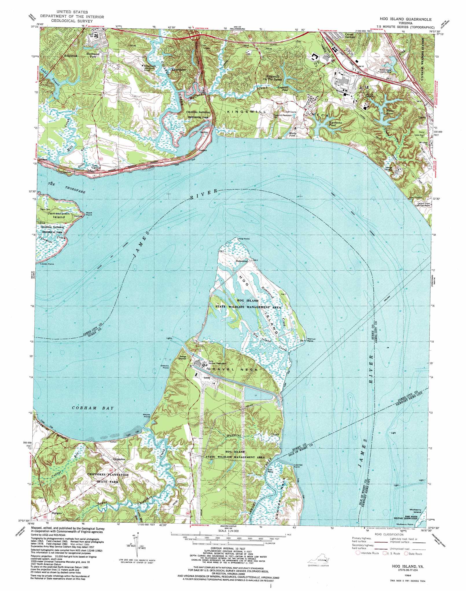
USGS Topo Quad 37076b6 - 1:24,000 scale
| Topo Map Name: | Hog Island |
| USGS Topo Quad ID: | 37076b6 |
| Print Size: | ca. 21 1/4" wide x 27" high |
| Southeast Coordinates: | 37.125° N latitude / 76.625° W longitude |
| Map Center Coordinates: | 37.1875° N latitude / 76.6875° W longitude |
| U.S. State: | VA |
| Filename: | o37076b6.jpg |
| Download Map JPG Image: | Hog Island topo map 1:24,000 scale |
| Map Type: | Topographic |
| Topo Series: | 7.5´ |
| Map Scale: | 1:24,000 |
| Source of Map Images: | United States Geological Survey (USGS) |
| Alternate Map Versions: |
Cobham Bay VA 1950, updated 1953 Download PDF Buy paper map Cobham Bay VA 1957, updated 1960 Download PDF Buy paper map Hog Island VA 1965, updated 1966 Download PDF Buy paper map Hog Island VA 1965, updated 1972 Download PDF Buy paper map Hog Island VA 1965, updated 1973 Download PDF Buy paper map Hog Island VA 1965, updated 1980 Download PDF Buy paper map Hog Island VA 1984, updated 1984 Download PDF Buy paper map Hog Island VA 1984, updated 1984 Download PDF Buy paper map Hog Island VA 1999, updated 2001 Download PDF Buy paper map Hog Island VA 2010 Download PDF Buy paper map Hog Island VA 2013 Download PDF Buy paper map Hog Island VA 2016 Download PDF Buy paper map |
1:24,000 Topo Quads surrounding Hog Island
Walkers |
Toano |
Gressitt |
Gloucester |
Ware Neck |
Brandon |
Norge |
Williamsburg |
Clay Bank |
Achilles |
Claremont |
Surry |
Hog Island |
Yorktown |
Poquoson West |
Dendron |
Runnymede |
Bacons Castle |
Mulberry Island |
Newport News North |
Ivor |
Raynor |
Smithfield |
Benns Church |
Newport News South |
> Back to 37076a1 at 1:100,000 scale
> Back to 37076a1 at 1:250,000 scale
> Back to U.S. Topo Maps home
Hog Island topo map: Gazetteer
Hog Island: Airports
Williamsburg-Jamestown Airport elevation 15m 49′Hog Island: Bays
Cobham Bay elevation 0m 0′Hog Island: Capes
Bayse Point elevation 1m 3′Black Point elevation 0m 0′
Drewry Point elevation 0m 0′
Gravel Neck elevation 10m 32′
Hog Point elevation 0m 0′
Kingsmill Neck elevation 18m 59′
Lawnes Point elevation 2m 6′
Lower Point elevation 1m 3′
Mulberry Point elevation 0m 0′
Walnut Point elevation 1m 3′
Hog Island: Channels
Goose Hill Channel elevation 0m 0′The Thorofare elevation 0m 0′
Tribell Shoal Channel elevation 0m 0′
Hog Island: Cliffs
Chestnut Bluffs elevation 16m 52′Hog Island: Crossings
Interchange 243 elevation 27m 88′Hog Island: Dams
Brewery Road Dam elevation 6m 19′Conference Center Dam elevation 3m 9′
Kingsmill Dam elevation 3m 9′
Lake Powell Dam elevation 3m 9′
Williamsburg Country Club Dam elevation 7m 22′
Hog Island: Guts
Hog Island Creek elevation 2m 6′Hog Island: Islands
Hog Island elevation 1m 3′Hog Island: Parks
Busch Gardens elevation 17m 55′Chippokes Plantation State Park elevation 19m 62′
Hog Island State Waterfowl Refuge elevation 0m 0′
Hog Island: Populated Places
Birchwood Park elevation 16m 52′Chippokes elevation 20m 65′
Country Club Acres elevation 23m 75′
Grove elevation 27m 88′
Highgate elevation 22m 72′
Hollybrook elevation 22m 72′
Homewood elevation 1m 3′
Kingsmill on the James elevation 21m 68′
Kingspoint elevation 23m 75′
Kingswood elevation 22m 72′
The Colony elevation 15m 49′
Hog Island: Reservoirs
Brewery Road Lake elevation 6m 19′Kingsmill Pond elevation 3m 9′
Lake Powell elevation 3m 9′
Moody Pond elevation 2m 6′
Rhine River elevation 6m 19′
Warehams Pond elevation 3m 9′
Williamsburg Country Club Lake elevation 7m 22′
Hog Island: Streams
Blizzards Creek elevation 4m 13′Castle Mill Run elevation 0m 0′
College Creek elevation 0m 0′
College Run elevation 1m 3′
Grove Creek elevation 1m 3′
Halfway Creek elevation 0m 0′
Homewood Creek elevation 1m 3′
Hunnicut Creek elevation 1m 3′
Lawnes Creek elevation 0m 0′
Lower Chippokes Creek elevation 5m 16′
Mill Creek elevation 12m 39′
Hog Island: Trails
College Run Trail elevation 20m 65′Forestry Trail elevation 4m 13′
James River Trail elevation 10m 32′
Lower Chippokes Creek Trail elevation 8m 26′
Hog Island digital topo map on disk
Buy this Hog Island topo map showing relief, roads, GPS coordinates and other geographical features, as a high-resolution digital map file on DVD:
Atlantic Coast (NY, NJ, PA, DE, MD, VA, NC)
Buy digital topo maps: Atlantic Coast (NY, NJ, PA, DE, MD, VA, NC)
 map DVD")