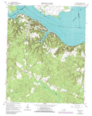
Claremont Topo Map Virginia
To zoom in, hover over the map of Claremont
USGS Topo Quad 37076b8 - 1:24,000 scale
| Topo Map Name: | Claremont |
| USGS Topo Quad ID: | 37076b8 |
| Print Size: | ca. 21 1/4" wide x 27" high |
| Southeast Coordinates: | 37.125° N latitude / 76.875° W longitude |
| Map Center Coordinates: | 37.1875° N latitude / 76.9375° W longitude |
| U.S. State: | VA |
| Filename: | o37076b8.jpg |
| Download Map JPG Image: | Claremont topo map 1:24,000 scale |
| Map Type: | Topographic |
| Topo Series: | 7.5´ |
| Map Scale: | 1:24,000 |
| Source of Map Images: | United States Geological Survey (USGS) |
| Alternate Map Versions: |
Claremont VA 1954, updated 1957 Download PDF Buy paper map Claremont VA 1966, updated 1966 Download PDF Buy paper map Claremont VA 1966, updated 1984 Download PDF Buy paper map Claremont VA 1966, updated 1986 Download PDF Buy paper map Claremont VA 1966, updated 1986 Download PDF Buy paper map Claremont VA 1978, updated 1983 Download PDF Buy paper map Claremont VA 2011 Download PDF Buy paper map Claremont VA 2013 Download PDF Buy paper map Claremont VA 2016 Download PDF Buy paper map |
1:24,000 Topo Quads surrounding Claremont
> Back to 37076a1 at 1:100,000 scale
> Back to 37076a1 at 1:250,000 scale
> Back to U.S. Topo Maps home
Claremont topo map: Gazetteer
Claremont: Capes
Chippokes Point elevation 1m 3′Claremont Point elevation 1m 3′
Dancing Point elevation 0m 0′
During Point elevation 0m 0′
Ferry Point elevation 1m 3′
Sandy Point elevation 0m 0′
Sloop Point elevation 0m 0′
Claremont: Crossings
Claremont-Sandy Point Ferry (historical) elevation 0m 0′Claremont: Dams
Eastover Dam elevation 32m 104′Sunken Meadow Dam elevation 6m 19′
Claremont: Populated Places
Claremont elevation 38m 124′Claremont Manor elevation 32m 104′
Eastover elevation 27m 88′
Guilford Heights elevation 32m 104′
Spring Grove elevation 40m 131′
Sunken Meadow Beach elevation 10m 32′
Tettington elevation 2m 6′
Wakefield elevation 20m 65′
Claremont: Post Offices
Claremont Post Office elevation 38m 124′Spring Grove Post Office elevation 37m 121′
Claremont: Reservoirs
Eastover Pond elevation 32m 104′Sunken Meadow Lake elevation 3m 9′
Sunken Meadow Pond elevation 6m 19′
Claremont: Streams
Brandon Gut elevation 0m 0′Chickahominy River elevation 0m 0′
Spring Grove Swamp elevation 30m 98′
Sunken Meadow Creek elevation 0m 0′
Tomahund Creek elevation 0m 0′
Upper Chippokes Creek elevation 0m 0′
Claremont digital topo map on disk
Buy this Claremont topo map showing relief, roads, GPS coordinates and other geographical features, as a high-resolution digital map file on DVD:
Atlantic Coast (NY, NJ, PA, DE, MD, VA, NC)
Buy digital topo maps: Atlantic Coast (NY, NJ, PA, DE, MD, VA, NC)


