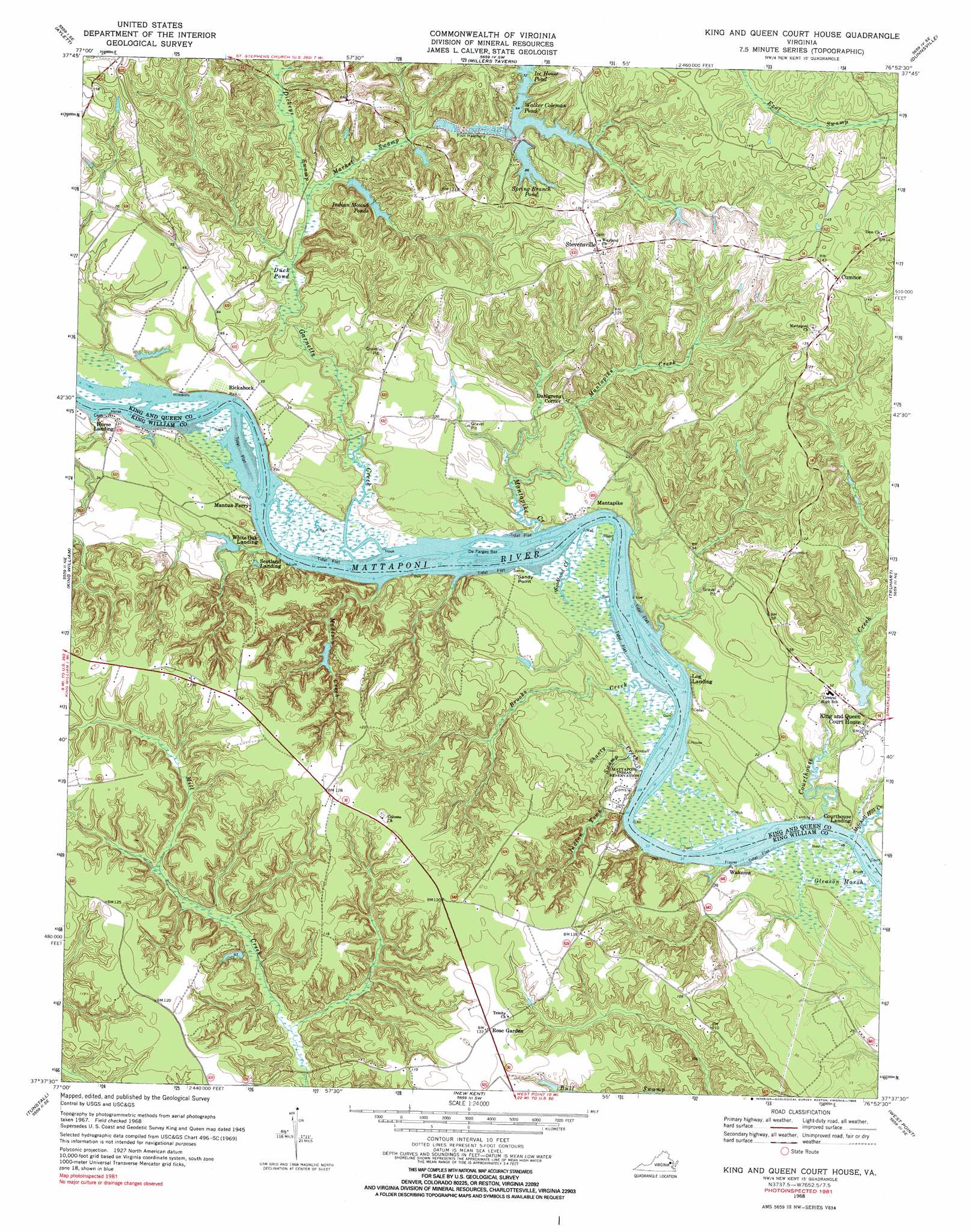
King And Queen Court House Topo Map Virginia
To zoom in, hover over the map of King And Queen Court House
USGS Topo Quad 37076f8 - 1:24,000 scale
| Topo Map Name: | King And Queen Court House |
| USGS Topo Quad ID: | 37076f8 |
| Print Size: | ca. 21 1/4" wide x 27" high |
| Southeast Coordinates: | 37.625° N latitude / 76.875° W longitude |
| Map Center Coordinates: | 37.6875° N latitude / 76.9375° W longitude |
| U.S. State: | VA |
| Filename: | o37076f8.jpg |
| Download Map JPG Image: | King And Queen Court House topo map 1:24,000 scale |
| Map Type: | Topographic |
| Topo Series: | 7.5´ |
| Map Scale: | 1:24,000 |
| Source of Map Images: | United States Geological Survey (USGS) |
| Alternate Map Versions: |
King And Queen VA 1949 Download PDF Buy paper map King And Queen VA 1949 Download PDF Buy paper map King And Queen Court House VA 1968, updated 1971 Download PDF Buy paper map King And Queen Court House VA 1968, updated 1985 Download PDF Buy paper map King And Queen Court House VA 2011 Download PDF Buy paper map King And Queen Court House VA 2013 Download PDF Buy paper map King And Queen Court House VA 2016 Download PDF Buy paper map |
1:24,000 Topo Quads surrounding King And Queen Court House
Sparta |
Cauthornville |
Mount Landing |
Tappahannock |
Haynesville |
Beulahville |
Aylett |
Millers Tavern |
Dunnsville |
Morattico |
Manquin |
King William |
King And Queen Court House |
Truhart |
Church View |
Quinton |
Tunstall |
New Kent |
West Point |
Shacklefords |
Roxbury |
Providence Forge |
Walkers |
Toano |
Gressitt |
> Back to 37076e1 at 1:100,000 scale
> Back to 37076a1 at 1:250,000 scale
> Back to U.S. Topo Maps home
King And Queen Court House topo map: Gazetteer
King And Queen Court House: Airports
Frog Hollow Farm Airport elevation 8m 26′King And Queen Court House: Bars
De Farges Bar elevation -1m -4′King And Queen Court House: Dams
Garretts Dam elevation 3m 9′Ice House Dam elevation 20m 65′
Indian Mound Ponds Dam elevation 12m 39′
King and Queen Courthouse Dam elevation 5m 16′
Powers Dam elevation 20m 65′
Stevensville Dam elevation 20m 65′
Walker Coleman Dam elevation 24m 78′
King And Queen Court House: Lakes
Duck Pond elevation 2m 6′King And Queen Court House: Populated Places
Courthouse Landing elevation 3m 9′Cumnor elevation 48m 157′
Dahlgrens Corner elevation 19m 62′
Hillsboro elevation 5m 16′
Horse Landing elevation 7m 22′
King and Queen Court House elevation 12m 39′
Log Landing elevation 1m 3′
Mantapike elevation 11m 36′
Rickahock elevation 0m 0′
Scotland Landing elevation 7m 22′
Stevensville elevation 48m 157′
Wakema elevation 4m 13′
White Oak Landing elevation 0m 0′
King And Queen Court House: Post Offices
King and Queen Court House Post Office elevation 11m 36′King And Queen Court House: Reservoirs
Ice House Pond elevation 20m 65′Indian Mound Ponds elevation 12m 39′
King and Queen Courthouse Pond elevation 5m 16′
Powers Pond elevation 20m 65′
Spring Branch Pond elevation 26m 85′
Stevensville Pond elevation 20m 65′
Walker Coleman Pond elevation 24m 78′
King And Queen Court House: Streams
Brooks Creek elevation 0m 0′Courthouse Creek elevation 4m 13′
Dickeys Swamp elevation 2m 6′
Garnetts Creek elevation 2m 6′
Indian Town Swamp elevation 0m 0′
Madison Creek elevation 0m 0′
Mantapike Creek elevation 0m 0′
Market Swamp elevation 2m 6′
Mitchell Hill Creek elevation 0m 0′
Shanty Creek elevation 2m 6′
Woodland Creek elevation 1m 3′
King And Queen Court House digital topo map on disk
Buy this King And Queen Court House topo map showing relief, roads, GPS coordinates and other geographical features, as a high-resolution digital map file on DVD:
Atlantic Coast (NY, NJ, PA, DE, MD, VA, NC)
Buy digital topo maps: Atlantic Coast (NY, NJ, PA, DE, MD, VA, NC)
 map DVD")