Heathsville Topo Map Virginia
To zoom in, hover over the map of Heathsville
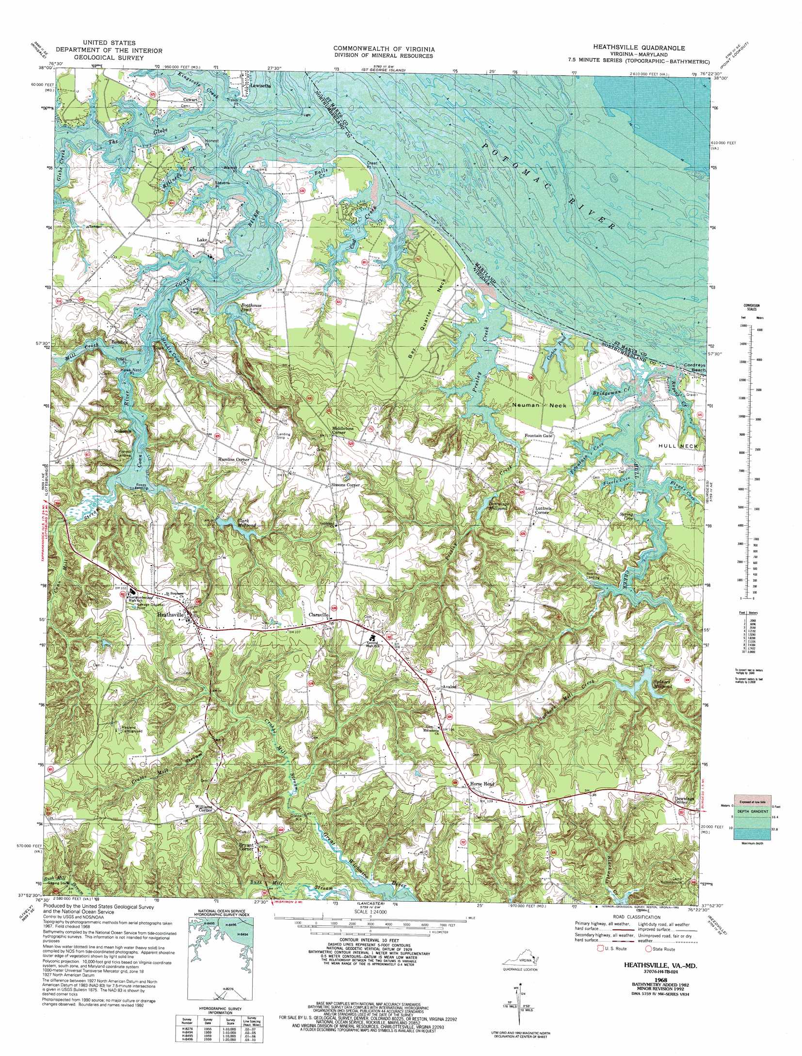
USGS Topo Quad 37076h4 - 1:24,000 scale
| Topo Map Name: | Heathsville |
| USGS Topo Quad ID: | 37076h4 |
| Print Size: | ca. 21 1/4" wide x 27" high |
| Southeast Coordinates: | 37.875° N latitude / 76.375° W longitude |
| Map Center Coordinates: | 37.9375° N latitude / 76.4375° W longitude |
| U.S. States: | VA, MD |
| Filename: | o37076h4.jpg |
| Download Map JPG Image: | Heathsville topo map 1:24,000 scale |
| Map Type: | Topographic |
| Topo Series: | 7.5´ |
| Map Scale: | 1:24,000 |
| Source of Map Images: | United States Geological Survey (USGS) |
| Alternate Map Versions: |
Heathsville VA 1953 Download PDF Buy paper map Heathsville VA 1962 Download PDF Buy paper map Heathsville VA 1968, updated 1971 Download PDF Buy paper map Heathsville VA 1968, updated 1983 Download PDF Buy paper map Heathsville VA 1968, updated 1993 Download PDF Buy paper map Heathsville VA 2011 Download PDF Buy paper map Heathsville VA 2013 Download PDF Buy paper map Heathsville VA 2016 Download PDF Buy paper map |
1:24,000 Topo Quads surrounding Heathsville
Saint Clements Island |
Piney Point |
Saint Marys City |
Point No Point |
Richland Point |
Machodoc |
Kinsale |
Saint George Island |
Point Lookout |
East Of Point Lookout |
Haynesville |
Lottsburg |
Heathsville |
Burgess |
Smith Point |
Morattico |
Lively |
Lancaster |
Reedville |
East of Reedville |
Church View |
Urbanna |
Irvington |
Fleets Bay |
East of Fleets Bay |
> Back to 37076e1 at 1:100,000 scale
> Back to 37076a1 at 1:250,000 scale
> Back to U.S. Topo Maps home
Heathsville topo map: Gazetteer
Heathsville: Airports
Heathsville Airport elevation 30m 98′Heathsville: Bays
Fleets Cove elevation 0m 0′Floyds Cove elevation 9m 29′
Fountain Cove elevation 0m 0′
Headly Cove elevation 0m 0′
Spring Cove elevation 2m 6′
The Glebe elevation 0m 0′
Heathsville: Capes
Bay Quarter Neck elevation 4m 13′Cowarts Point elevation 0m 0′
Hawk Nest Point elevation 1m 3′
Highland Point elevation 0m 0′
Honest Point elevation 3m 9′
Neuman Neck elevation 6m 19′
Popes Point elevation 1m 3′
Roger Point elevation 0m 0′
Stevens Point elevation 0m 0′
Walnut Point elevation 0m 0′
Heathsville: Crossings
Coan-Bundicks Ferry (historical) elevation 0m 0′Heathsville: Dams
Clarkes Milldam elevation 4m 13′Sydnors Millpond Dam elevation 3m 9′
Heathsville: Lakes
Boathouse Pond elevation 6m 19′Corbin Pond elevation 0m 0′
Heathsville: Populated Places
Avalon elevation 31m 101′Bryant Corner elevation 28m 91′
Bundick elevation 14m 45′
Claraville elevation 31m 101′
Coan elevation 3m 9′
Cowart elevation 3m 9′
Crabbe Mill elevation 2m 6′
Downings Corner elevation 31m 101′
Hamlins Corner elevation 29m 95′
Heathsville elevation 31m 101′
Horse Head elevation 35m 114′
Lake elevation 7m 22′
Lewisetta elevation 1m 3′
Luttrels Corner elevation 28m 91′
Middletons Corner elevation 33m 108′
Nokomis elevation 17m 55′
Sissons Corner elevation 35m 114′
Walnut Point (historical) elevation 0m 0′
Williams Corner elevation 29m 95′
Heathsville: Reservoirs
Clark Millpond elevation 4m 13′Clarkes Millpond elevation 6m 19′
Downings Millpond elevation 1m 3′
Sydnors Millpond elevation 3m 9′
Heathsville: Streams
Bridgeman Creek elevation 0m 0′Coan Mill Stream elevation 2m 6′
Coan River elevation 0m 0′
Cod Creek elevation 0m 0′
Crabbe Mill Stream elevation 5m 16′
Glebe Creek elevation 0m 0′
Hull Creek elevation 0m 0′
Killneck Creek elevation 0m 0′
Kingscote Creek elevation 0m 0′
Mill Creek elevation 0m 0′
Presley Creek elevation 0m 0′
Rogers Creek elevation 0m 0′
Sydnors Mill Creek elevation 3m 9′
Heathsville digital topo map on disk
Buy this Heathsville topo map showing relief, roads, GPS coordinates and other geographical features, as a high-resolution digital map file on DVD:
Atlantic Coast (NY, NJ, PA, DE, MD, VA, NC)
Buy digital topo maps: Atlantic Coast (NY, NJ, PA, DE, MD, VA, NC)
 map DVD")