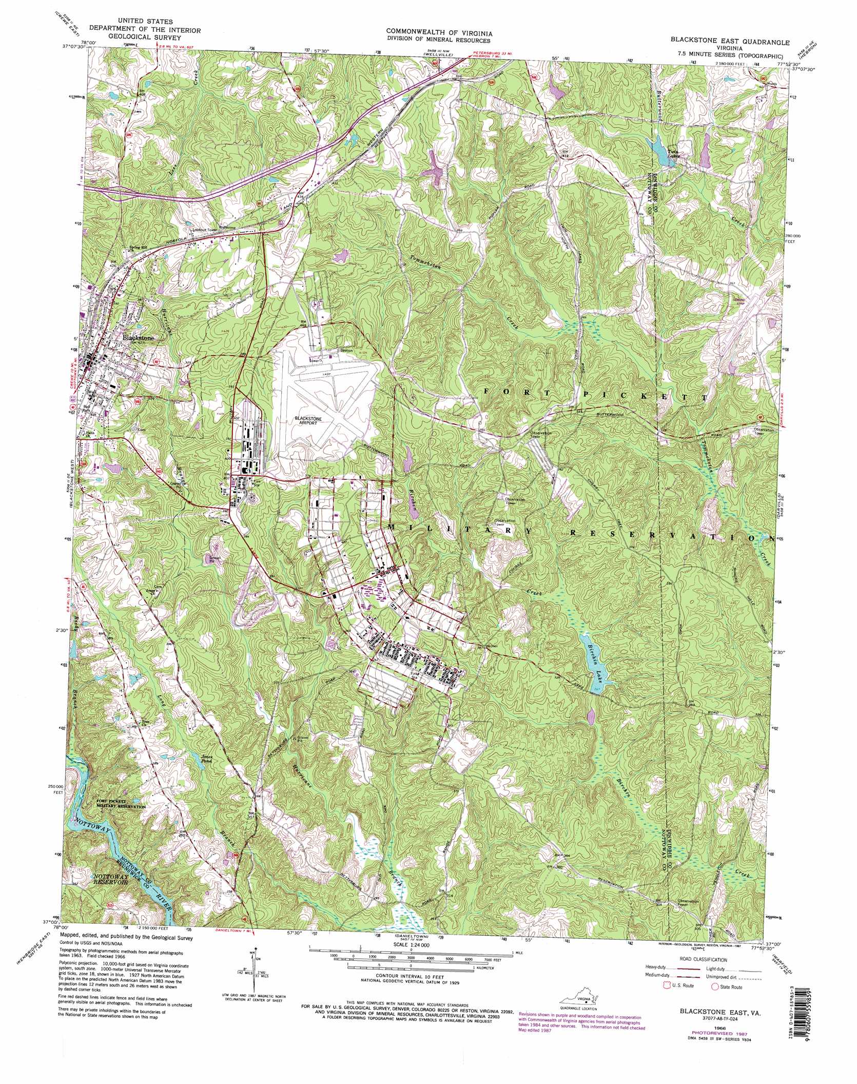
Blackstone East Topo Map Virginia
To zoom in, hover over the map of Blackstone East
USGS Topo Quad 37077a8 - 1:24,000 scale
| Topo Map Name: | Blackstone East |
| USGS Topo Quad ID: | 37077a8 |
| Print Size: | ca. 21 1/4" wide x 27" high |
| Southeast Coordinates: | 37° N latitude / 77.875° W longitude |
| Map Center Coordinates: | 37.0625° N latitude / 77.9375° W longitude |
| U.S. State: | VA |
| Filename: | o37077a8.jpg |
| Download Map JPG Image: | Blackstone East topo map 1:24,000 scale |
| Map Type: | Topographic |
| Topo Series: | 7.5´ |
| Map Scale: | 1:24,000 |
| Source of Map Images: | United States Geological Survey (USGS) |
| Alternate Map Versions: |
Blackstone East VA 1966, updated 1967 Download PDF Buy paper map Blackstone East VA 1966, updated 1976 Download PDF Buy paper map Blackstone East VA 1966, updated 1981 Download PDF Buy paper map Blackstone East VA 1966, updated 1987 Download PDF Buy paper map Blackstone East VA 1966, updated 1987 Download PDF Buy paper map Blackstone East VA 2010 Download PDF Buy paper map Blackstone East VA 2013 Download PDF Buy paper map Blackstone East VA 2016 Download PDF Buy paper map |
1:24,000 Topo Quads surrounding Blackstone East
Deatonville |
Jetersville |
Amelia Court House |
Mannboro |
Winterpock |
Crewe West |
Crewe East |
Wellville |
Hebron |
Church Road |
Rubermont |
Blackstone West |
Blackstone East |
Darvills |
De Witt |
Kenbridge West |
Kenbridge East |
Danieltown |
Warfield |
Mckenney |
North View |
Forksville |
Alberta |
Lawrenceville |
Smoky Ordinary |
> Back to 37077a1 at 1:100,000 scale
> Back to 37076a1 at 1:250,000 scale
> Back to U.S. Topo Maps home
Blackstone East topo map: Gazetteer
Blackstone East: Airports
Allen C Perkinson Municipal Airport elevation 129m 423′Blackstone East: Dams
Birchin Dam elevation 75m 246′Butterwood Lake Upper Dam elevation 107m 351′
Butterwood Lower Dam elevation 99m 324′
Tactical Bridge Dam elevation 102m 334′
Tommeheton Creek Dam elevation 120m 393′
Blackstone East: Populated Places
Blackstone elevation 131m 429′Forkland (historical) elevation 104m 341′
Westboro (historical) elevation 104m 341′
Blackstone East: Post Offices
Blackstone Post Office elevation 130m 426′Blackstone East: Reservoirs
Birchin Lake elevation 75m 246′Butterwood Lake elevation 107m 351′
Jones Pond elevation 94m 308′
Pryor Road Reservoir elevation 102m 334′
Twin Lakes elevation 98m 321′
Blackstone East: Streams
Long Branch elevation 65m 213′Reedy Branch elevation 68m 223′
Blackstone East digital topo map on disk
Buy this Blackstone East topo map showing relief, roads, GPS coordinates and other geographical features, as a high-resolution digital map file on DVD:
Atlantic Coast (NY, NJ, PA, DE, MD, VA, NC)
Buy digital topo maps: Atlantic Coast (NY, NJ, PA, DE, MD, VA, NC)
 map DVD")