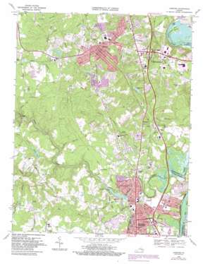
Chester Topo Map Virginia
To zoom in, hover over the map of Chester
USGS Topo Quad 37077c4 - 1:24,000 scale
| Topo Map Name: | Chester |
| USGS Topo Quad ID: | 37077c4 |
| Print Size: | ca. 21 1/4" wide x 27" high |
| Southeast Coordinates: | 37.25° N latitude / 77.375° W longitude |
| Map Center Coordinates: | 37.3125° N latitude / 77.4375° W longitude |
| U.S. State: | VA |
| Filename: | o37077c4.jpg |
| Download Map JPG Image: | Chester topo map 1:24,000 scale |
| Map Type: | Topographic |
| Topo Series: | 7.5´ |
| Map Scale: | 1:24,000 |
| Source of Map Images: | United States Geological Survey (USGS) |
| Alternate Map Versions: |
Chester VA 1952, updated 1959 Download PDF Buy paper map Chester VA 1969, updated 1971 Download PDF Buy paper map Chester VA 1969, updated 1975 Download PDF Buy paper map Chester VA 1969, updated 1981 Download PDF Buy paper map Chester VA 1969, updated 1987 Download PDF Buy paper map Chester VA 1974, updated 1977 Download PDF Buy paper map Chester VA 1994, updated 1996 Download PDF Buy paper map Chester VA 2010 Download PDF Buy paper map Chester VA 2013 Download PDF Buy paper map Chester VA 2016 Download PDF Buy paper map |
1:24,000 Topo Quads surrounding Chester
> Back to 37077a1 at 1:100,000 scale
> Back to 37076a1 at 1:250,000 scale
> Back to U.S. Topo Maps home
Chester topo map: Gazetteer
Chester: Airports
Fire Station Number 14 Heliport elevation 51m 167′Technical Center Heliport elevation 22m 72′
Chester: Bridges
Bradley Bridge elevation 28m 91′Branders Bridge elevation 15m 49′
Chester: Channels
James River Old Channel elevation 0m 0′Old North Channel elevation 1m 3′
Chester: Crossings
Interchange 54 elevation 11m 36′Interchange 58 elevation 24m 78′
Interchange 61 elevation 51m 167′
Chester: Dams
Andrews Dam elevation 36m 118′Chester Club Dam elevation 57m 187′
Lake Neda Dam elevation 54m 177′
Lake View Dam elevation 22m 72′
Pells Dam elevation 52m 170′
Rieves Dam elevation 35m 114′
Chester: Harbors
Appomattox Small Boat Harbor elevation 2m 6′Chester: Parks
Harrowgate Park elevation 33m 108′Matoaca Park elevation 48m 157′
Tot Playground elevation 21m 68′
White Bank Park elevation 5m 16′
Chester: Populated Places
Archer Bluff elevation 20m 65′Autumn Oaks elevation 49m 160′
Bermuda Place elevation 55m 180′
Boulevard Heights elevation 15m 49′
Braebrook Village elevation 29m 95′
Bryan Ridge elevation 50m 164′
Carver Homes elevation 54m 177′
Chester elevation 53m 173′
Chesterbrook Farms elevation 48m 157′
Columbia Park elevation 52m 170′
Dunlop elevation 20m 65′
Dutch Gap elevation 48m 157′
Edenshire elevation 54m 177′
Gay Farms elevation 51m 167′
Glebe Point elevation 49m 160′
Greenbriar elevation 51m 167′
Greenleigh Mobile Home Park elevation 39m 127′
Grove Place elevation 52m 170′
Hidden Valley Estates elevation 49m 160′
Lakeview elevation 27m 88′
Lakewood Estates elevation 57m 187′
Locust Grove elevation 51m 167′
Lora Lynn Heights elevation 48m 157′
Mistwood Forest elevation 49m 160′
Pickadat Corner elevation 23m 75′
Pineland elevation 27m 88′
Preston Place elevation 51m 167′
Shadowbrook Heights elevation 36m 118′
Sherwood Hills elevation 19m 62′
Somerset elevation 30m 98′
Stafford Place elevation 52m 170′
Tinsberry Trace elevation 37m 121′
Victoria Hills elevation 51m 167′
Walthall elevation 29m 95′
Windsor Hills elevation 49m 160′
Woodlawn elevation 21m 68′
Chester: Post Offices
Chester Post Office elevation 55m 180′Colonial Heights Post Office elevation 27m 88′
Chester: Reservoirs
Andrews Pond elevation 36m 118′Chester Club Lake elevation 57m 187′
Lake Neda elevation 54m 177′
Lake View Lake elevation 22m 72′
Moore Lake elevation 28m 91′
Pells Pond elevation 52m 170′
Redwater Lake elevation 35m 114′
Rieves Lake elevation 35m 114′
Swift Creek Lake elevation 15m 49′
Chester: Streams
Beach Branch elevation 25m 82′Big Branch elevation 25m 82′
Church Branch elevation 36m 118′
Franks Branch elevation 34m 111′
Long Swamp elevation 35m 114′
Oldtown Creek elevation 0m 0′
Timsbury Creek elevation 1m 3′
Chester digital topo map on disk
Buy this Chester topo map showing relief, roads, GPS coordinates and other geographical features, as a high-resolution digital map file on DVD:
Atlantic Coast (NY, NJ, PA, DE, MD, VA, NC)
Buy digital topo maps: Atlantic Coast (NY, NJ, PA, DE, MD, VA, NC)


