Beach Topo Map Virginia
To zoom in, hover over the map of Beach
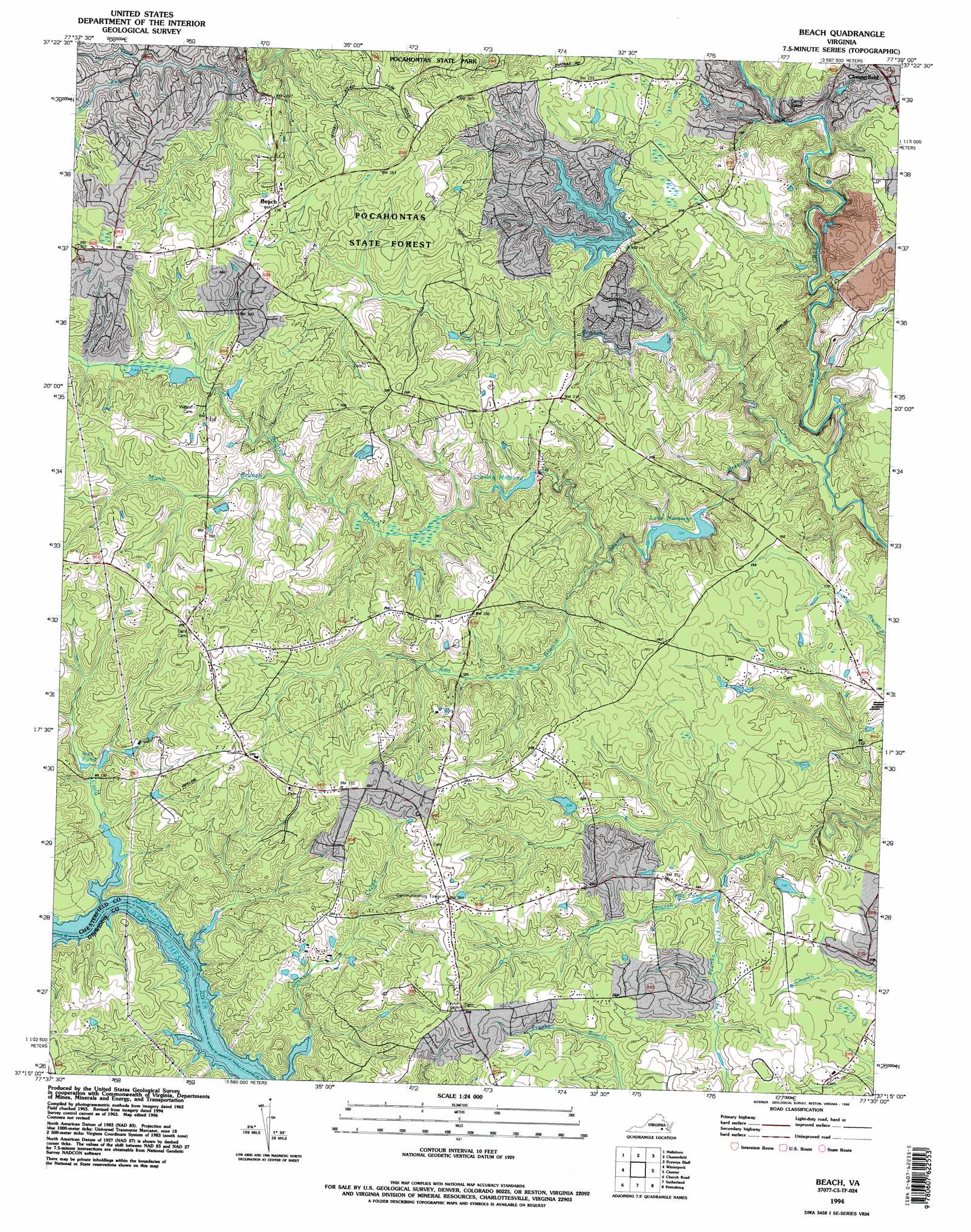
USGS Topo Quad 37077c5 - 1:24,000 scale
| Topo Map Name: | Beach |
| USGS Topo Quad ID: | 37077c5 |
| Print Size: | ca. 21 1/4" wide x 27" high |
| Southeast Coordinates: | 37.25° N latitude / 77.5° W longitude |
| Map Center Coordinates: | 37.3125° N latitude / 77.5625° W longitude |
| U.S. State: | VA |
| Filename: | o37077c5.jpg |
| Download Map JPG Image: | Beach topo map 1:24,000 scale |
| Map Type: | Topographic |
| Topo Series: | 7.5´ |
| Map Scale: | 1:24,000 |
| Source of Map Images: | United States Geological Survey (USGS) |
| Alternate Map Versions: |
Beach VA 1943, updated 1961 Download PDF Buy paper map Beach VA 1963, updated 1965 Download PDF Buy paper map Beach VA 1963, updated 1969 Download PDF Buy paper map Beach VA 1963, updated 1975 Download PDF Buy paper map Beach VA 1963, updated 1981 Download PDF Buy paper map Beach VA 1963, updated 1987 Download PDF Buy paper map Beach VA 1974, updated 1977 Download PDF Buy paper map Beach VA 1994, updated 1996 Download PDF Buy paper map Beach VA 2010 Download PDF Buy paper map Beach VA 2013 Download PDF Buy paper map Beach VA 2016 Download PDF Buy paper map |
1:24,000 Topo Quads surrounding Beach
Fine Creek Mills |
Midlothian |
Bon Air |
Richmond |
Seven Pines |
Clayville |
Hallsboro |
Chesterfield |
Drewrys Bluff |
Dutch Gap |
Mannboro |
Winterpock |
Beach |
Chester |
Hopewell |
Hebron |
Church Road |
Sutherland |
Petersburg |
Prince George |
Darvills |
De Witt |
Dinwiddie |
Carson |
Templeton |
> Back to 37077a1 at 1:100,000 scale
> Back to 37076a1 at 1:250,000 scale
> Back to U.S. Topo Maps home
Beach topo map: Gazetteer
Beach: Dams
Crostick Dam elevation 52m 170′Lake Dale Dam elevation 44m 144′
Lake Margaret Dam elevation 40m 131′
Nash Road Lake Dam elevation 53m 173′
Vaughn Dam elevation 57m 187′
Beach: Forests
Pocahontas State Forest elevation 78m 255′Beach: Populated Places
Fendley (historical) elevation 83m 272′Leader elevation 93m 305′
Nash Grove elevation 96m 314′
Beach: Reservoirs
Crostick Millpond elevation 52m 170′Gills Pond elevation 47m 154′
Ivys Ponds elevation 43m 141′
Lake Dale elevation 41m 134′
Lake Margaret elevation 40m 131′
Nash Road Lake elevation 53m 173′
Beach: Streams
Cattle Creek elevation 47m 154′First Branch elevation 41m 134′
Licking Creek elevation 19m 62′
Locust Branch elevation 54m 177′
Mann Branch elevation 56m 183′
Piney Branch elevation 32m 104′
Rita Branch elevation 49m 160′
Rocky Run elevation 55m 180′
Second Branch elevation 27m 88′
Beach digital topo map on disk
Buy this Beach topo map showing relief, roads, GPS coordinates and other geographical features, as a high-resolution digital map file on DVD:
Atlantic Coast (NY, NJ, PA, DE, MD, VA, NC)
Buy digital topo maps: Atlantic Coast (NY, NJ, PA, DE, MD, VA, NC)
 map DVD")