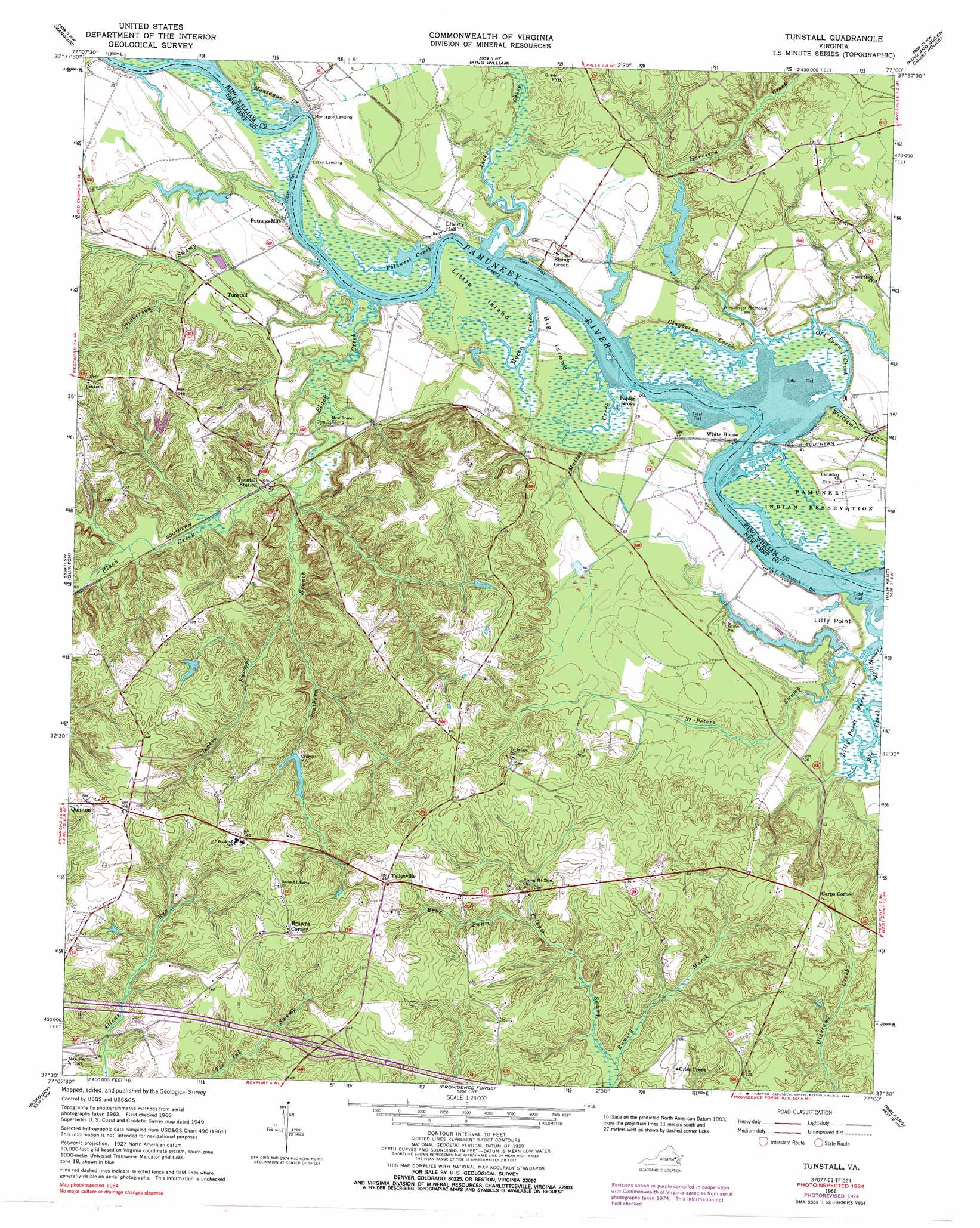
Tunstall Topo Map Virginia
To zoom in, hover over the map of Tunstall
USGS Topo Quad 37077e1 - 1:24,000 scale
| Topo Map Name: | Tunstall |
| USGS Topo Quad ID: | 37077e1 |
| Print Size: | ca. 21 1/4" wide x 27" high |
| Southeast Coordinates: | 37.5° N latitude / 77° W longitude |
| Map Center Coordinates: | 37.5625° N latitude / 77.0625° W longitude |
| U.S. State: | VA |
| Filename: | o37077e1.jpg |
| Download Map JPG Image: | Tunstall topo map 1:24,000 scale |
| Map Type: | Topographic |
| Topo Series: | 7.5´ |
| Map Scale: | 1:24,000 |
| Source of Map Images: | United States Geological Survey (USGS) |
| Alternate Map Versions: |
Tunstall VA 1949 Download PDF Buy paper map Tunstall VA 1966, updated 1968 Download PDF Buy paper map Tunstall VA 1966, updated 1975 Download PDF Buy paper map Tunstall VA 1966, updated 1985 Download PDF Buy paper map Tunstall VA 1966, updated 1988 Download PDF Buy paper map Tunstall VA 1974, updated 1977 Download PDF Buy paper map Tunstall VA 2010 Download PDF Buy paper map Tunstall VA 2013 Download PDF Buy paper map Tunstall VA 2016 Download PDF Buy paper map |
1:24,000 Topo Quads surrounding Tunstall
Hanover |
Beulahville |
Aylett |
Millers Tavern |
Dunnsville |
Studley |
Manquin |
King William |
King And Queen Court House |
Truhart |
Seven Pines |
Quinton |
Tunstall |
New Kent |
West Point |
Dutch Gap |
Roxbury |
Providence Forge |
Walkers |
Toano |
Hopewell |
Westover |
Charles City |
Brandon |
Norge |
> Back to 37077e1 at 1:100,000 scale
> Back to 37076a1 at 1:250,000 scale
> Back to U.S. Topo Maps home
Tunstall topo map: Gazetteer
Tunstall: Bars
Gregory Bar elevation 1m 3′Ringer Bar elevation 0m 0′
Rockahock Bar elevation 1m 3′
Tunstall: Capes
Lilly Point elevation 0m 0′Tunstall: Crossings
Interchange 211 elevation 31m 101′Tunstall: Dams
Groves Dam elevation 22m 72′Lafferty Dam elevation 1m 3′
Lafferty Dam Number Two elevation 3m 9′
Tunstall: Islands
Big Island elevation 7m 22′Little Island elevation 2m 6′
Tunstall: Populated Places
Browns Corner elevation 46m 150′Carps Corner elevation 33m 108′
Crumps Mill elevation 25m 82′
Elsing Green elevation 18m 59′
Poplar Grove elevation 5m 16′
Putneys Mill elevation 3m 9′
Quinton elevation 38m 124′
Richardson (historical) elevation 7m 22′
Tallysville elevation 44m 144′
Tunstall elevation 14m 45′
Tunstall: Reservoirs
Groves Lake elevation 22m 72′Lafferty Pond elevation 1m 3′
Tunstall: Streams
Beus Swamp elevation 17m 55′Black Creek elevation 1m 3′
Broad Creek elevation 6m 19′
Clayborne Creek elevation 1m 3′
Clopton Swamp elevation 4m 13′
Dickerson Swamp elevation 1m 3′
Harrison Creek elevation 1m 3′
Jacks Creek elevation 0m 0′
Macon Creek elevation 0m 0′
Mallory Creek elevation 0m 0′
Matton Creek elevation 0m 0′
Montague Creek elevation 0m 0′
Old Town Creek elevation 0m 0′
Pelham Swamp elevation 8m 26′
Polkwest Creek elevation 1m 3′
Saint Peters Swamp elevation 2m 6′
Southern Branch elevation 0m 0′
White House Creek elevation 1m 3′
Tunstall digital topo map on disk
Buy this Tunstall topo map showing relief, roads, GPS coordinates and other geographical features, as a high-resolution digital map file on DVD:
Atlantic Coast (NY, NJ, PA, DE, MD, VA, NC)
Buy digital topo maps: Atlantic Coast (NY, NJ, PA, DE, MD, VA, NC)
 map DVD")