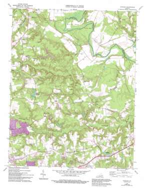
Studley Topo Map Virginia
To zoom in, hover over the map of Studley
USGS Topo Quad 37077f3 - 1:24,000 scale
| Topo Map Name: | Studley |
| USGS Topo Quad ID: | 37077f3 |
| Print Size: | ca. 21 1/4" wide x 27" high |
| Southeast Coordinates: | 37.625° N latitude / 77.25° W longitude |
| Map Center Coordinates: | 37.6875° N latitude / 77.3125° W longitude |
| U.S. State: | VA |
| Filename: | o37077f3.jpg |
| Download Map JPG Image: | Studley topo map 1:24,000 scale |
| Map Type: | Topographic |
| Topo Series: | 7.5´ |
| Map Scale: | 1:24,000 |
| Source of Map Images: | United States Geological Survey (USGS) |
| Alternate Map Versions: |
Studley VA 1951 Download PDF Buy paper map Studley VA 1964, updated 1965 Download PDF Buy paper map Studley VA 1964, updated 1975 Download PDF Buy paper map Studley VA 1964, updated 1982 Download PDF Buy paper map Studley VA 1964, updated 1987 Download PDF Buy paper map Studley VA 1964, updated 1994 Download PDF Buy paper map Studley VA 1974, updated 1977 Download PDF Buy paper map Studley VA 2010 Download PDF Buy paper map Studley VA 2013 Download PDF Buy paper map Studley VA 2016 Download PDF Buy paper map |
1:24,000 Topo Quads surrounding Studley
> Back to 37077e1 at 1:100,000 scale
> Back to 37076a1 at 1:250,000 scale
> Back to U.S. Topo Maps home
Studley topo map: Gazetteer
Studley: Airports
Robertson Airport elevation 52m 170′Woods Farm Airstrip elevation 20m 65′
Studley: Bridges
Nelson Bridge elevation 11m 36′Studley: Capes
Crump Neck elevation 11m 36′Sutton Neck elevation 12m 39′
Studley: Crossings
Interchange 38 elevation 51m 167′Nelson Ferry (historical) elevation 11m 36′
Studley: Dams
Colonial Forest Dam elevation 49m 160′Mattawan Association Dam elevation 35m 114′
Nanover Learning Center Dam elevation 20m 65′
Pebblebrook Dam elevation 50m 164′
Rainer Dam elevation 28m 91′
Talleys Dam elevation 41m 134′
Timberlake Dam Number One elevation 58m 190′
Timberlake Dam Number Two elevation 46m 150′
Studley: Populated Places
Avondale elevation 53m 173′Battlefield Green elevation 50m 164′
Bell Creek North elevation 52m 170′
Benthill elevation 55m 180′
Buckeye elevation 55m 180′
Cady elevation 30m 98′
Cherrydale elevation 47m 154′
Cherrydale West elevation 57m 187′
Colonial Forest elevation 56m 183′
Crosses Corner elevation 57m 187′
Fieldshire elevation 47m 154′
Georgetown elevation 55m 180′
Greenway elevation 49m 160′
Guilds Acres elevation 41m 134′
Heatherwood elevation 49m 160′
Hilly Farms elevation 44m 144′
Hughes Corner elevation 55m 180′
Hundleys Corner elevation 57m 187′
Locust Green elevation 28m 91′
Mattawan elevation 49m 160′
Meadow Gate elevation 52m 170′
Newman elevation 59m 193′
Oak Forest elevation 57m 187′
Orchard Gardens elevation 55m 180′
Pamunkey Estates elevation 34m 111′
Pebblebrook elevation 54m 177′
Pine Hill elevation 54m 177′
Pole Green elevation 59m 193′
Rainier Estates elevation 49m 160′
Raven Run elevation 56m 183′
Robin Ridge elevation 52m 170′
Shannondale Estates elevation 57m 187′
Strawhorn elevation 46m 150′
Studley elevation 53m 173′
Studley Farms elevation 54m 177′
Swannanoa Estates elevation 54m 177′
The Colonies elevation 47m 154′
Studley: Post Offices
Studley Post Office elevation 54m 177′Studley: Reservoirs
Cady Lake elevation 30m 98′Colonial Forest Lake elevation 49m 160′
Pebblebrook Lake elevation 50m 164′
Talley Millpond elevation 41m 134′
Talleys Millpond elevation 51m 167′
Timberlake Pond Number One elevation 58m 190′
Timberlake Pond Number Two elevation 46m 150′
Studley: Streams
Academy Creek elevation 32m 104′Cady Creek elevation 15m 49′
Campbell Creek elevation 22m 72′
Crump Creek elevation 10m 32′
Hawes Millrace elevation 18m 59′
Kersey Creek elevation 26m 85′
Mantilo Branch elevation 2m 6′
Millpond Creek elevation 6m 19′
Opossum Creek elevation 33m 108′
Pollard Creek elevation 15m 49′
Pong Swamp elevation 9m 29′
Strawhorn Creek elevation 24m 78′
Sullens Creek elevation 10m 32′
Studley digital topo map on disk
Buy this Studley topo map showing relief, roads, GPS coordinates and other geographical features, as a high-resolution digital map file on DVD:
Atlantic Coast (NY, NJ, PA, DE, MD, VA, NC)
Buy digital topo maps: Atlantic Coast (NY, NJ, PA, DE, MD, VA, NC)


