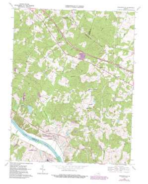
Perkinsville Topo Map Virginia
To zoom in, hover over the map of Perkinsville
USGS Topo Quad 37077f7 - 1:24,000 scale
| Topo Map Name: | Perkinsville |
| USGS Topo Quad ID: | 37077f7 |
| Print Size: | ca. 21 1/4" wide x 27" high |
| Southeast Coordinates: | 37.625° N latitude / 77.75° W longitude |
| Map Center Coordinates: | 37.6875° N latitude / 77.8125° W longitude |
| U.S. State: | VA |
| Filename: | o37077f7.jpg |
| Download Map JPG Image: | Perkinsville topo map 1:24,000 scale |
| Map Type: | Topographic |
| Topo Series: | 7.5´ |
| Map Scale: | 1:24,000 |
| Source of Map Images: | United States Geological Survey (USGS) |
| Alternate Map Versions: |
Perkinsville VA 1943, updated 1961 Download PDF Buy paper map Perkinsville VA 1968, updated 1970 Download PDF Buy paper map Perkinsville VA 1968, updated 1981 Download PDF Buy paper map Perkinsville VA 1968, updated 1987 Download PDF Buy paper map Perkinsville VA 2010 Download PDF Buy paper map Perkinsville VA 2013 Download PDF Buy paper map Perkinsville VA 2016 Download PDF Buy paper map |
1:24,000 Topo Quads surrounding Perkinsville
> Back to 37077e1 at 1:100,000 scale
> Back to 37076a1 at 1:250,000 scale
> Back to U.S. Topo Maps home
Perkinsville topo map: Gazetteer
Perkinsville: Airports
Bachman Farm Ultralight Airport elevation 103m 337′Perkinsville: Crossings
Interchange 167 elevation 90m 295′Perkinsville: Dams
Bowles Dam elevation 79m 259′Carter and Harrell Dam elevation 50m 164′
Lake Fullstream Dam elevation 72m 236′
Mount Bernard Dam elevation 63m 206′
Reynolds Dam elevation 81m 265′
Richmonds Dam elevation 51m 167′
Virginia State Farm Dam Number One elevation 71m 232′
Virginia State Farm Dam Number Three elevation 54m 177′
Perkinsville: Populated Places
Amber Lake elevation 90m 295′Beacon Hill elevation 107m 351′
Cardwell elevation 103m 337′
Chelsea elevation 89m 291′
Covington elevation 86m 282′
Crosswoods West elevation 86m 282′
Crozier elevation 99m 324′
Deerfield elevation 77m 252′
East Courthouse Estates elevation 82m 269′
Fair Woods elevation 69m 226′
Fox Downs elevation 113m 370′
Hillcrest elevation 62m 203′
Horsepen Hills elevation 77m 252′
Hunters Woods elevation 90m 295′
Huntleigh elevation 86m 282′
Maidens Forest elevation 98m 321′
Oaklands elevation 76m 249′
Oilville elevation 97m 318′
Old Oaks elevation 77m 252′
Perkinsville elevation 104m 341′
Poplar Forest elevation 91m 298′
River Cliff elevation 65m 213′
Smokey Hollow elevation 108m 354′
Strawberry Run elevation 71m 232′
The Forest elevation 79m 259′
Thorncliff elevation 64m 209′
Three Oaks elevation 90m 295′
Timber Ridge elevation 66m 216′
Whitehall Acres elevation 94m 308′
Perkinsville: Post Offices
Crozier Post Office elevation 99m 324′Perkinsville: Reservoirs
Carter and Harrell Lake elevation 50m 164′Horseshoe Pond elevation 81m 265′
Lake Fullstream elevation 72m 236′
Mount Bernard Lake elevation 63m 206′
Richmonds Pond elevation 51m 167′
Virginia State Farm Pond Number One elevation 71m 232′
Virginia State Farm Pond Number Three elevation 54m 177′
Perkinsville: Streams
Beaverdam Creek elevation 40m 131′Courthouse Creek elevation 45m 147′
East Fork Genito Creek elevation 59m 193′
Gammons Creek elevation 57m 187′
Horsepen Creek elevation 53m 173′
Hughes Creek elevation 41m 134′
West Fork Genito Creek elevation 59m 193′
Perkinsville digital topo map on disk
Buy this Perkinsville topo map showing relief, roads, GPS coordinates and other geographical features, as a high-resolution digital map file on DVD:
Atlantic Coast (NY, NJ, PA, DE, MD, VA, NC)
Buy digital topo maps: Atlantic Coast (NY, NJ, PA, DE, MD, VA, NC)


