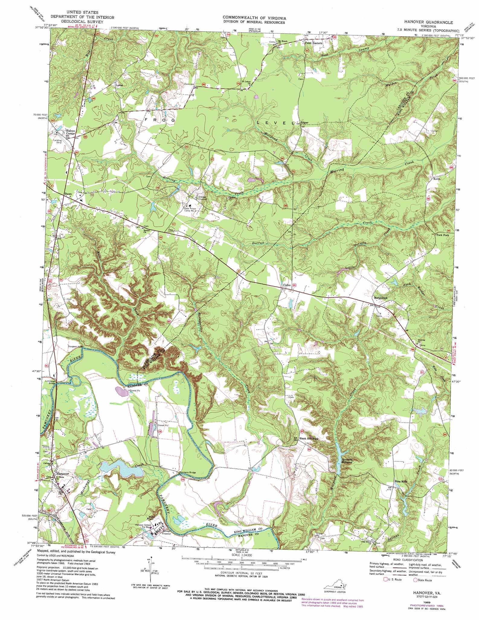
Hanover Topo Map Virginia
To zoom in, hover over the map of Hanover
USGS Topo Quad 37077g3 - 1:24,000 scale
| Topo Map Name: | Hanover |
| USGS Topo Quad ID: | 37077g3 |
| Print Size: | ca. 21 1/4" wide x 27" high |
| Southeast Coordinates: | 37.75° N latitude / 77.25° W longitude |
| Map Center Coordinates: | 37.8125° N latitude / 77.3125° W longitude |
| U.S. State: | VA |
| Filename: | o37077g3.jpg |
| Download Map JPG Image: | Hanover topo map 1:24,000 scale |
| Map Type: | Topographic |
| Topo Series: | 7.5´ |
| Map Scale: | 1:24,000 |
| Source of Map Images: | United States Geological Survey (USGS) |
| Alternate Map Versions: |
Hanover VA 1949, updated 1967 Download PDF Buy paper map Hanover VA 1951 Download PDF Buy paper map Hanover VA 1969, updated 1971 Download PDF Buy paper map Hanover VA 1969, updated 1977 Download PDF Buy paper map Hanover VA 1969, updated 1985 Download PDF Buy paper map Hanover VA 1969, updated 1985 Download PDF Buy paper map Hanover VA 2010 Download PDF Buy paper map Hanover VA 2013 Download PDF Buy paper map Hanover VA 2016 Download PDF Buy paper map |
1:24,000 Topo Quads surrounding Hanover
Ladysmith |
Woodford |
Bowling Green |
Supply |
Loretto |
Hewlett |
Ruther Glen |
Penola |
Sparta |
Cauthornville |
Hanover Academy |
Ashland |
Hanover |
Beulahville |
Aylett |
Glen Allen |
Yellow Tavern |
Studley |
Manquin |
King William |
Bon Air |
Richmond |
Seven Pines |
Quinton |
Tunstall |
> Back to 37077e1 at 1:100,000 scale
> Back to 37076a1 at 1:250,000 scale
> Back to U.S. Topo Maps home
Hanover topo map: Gazetteer
Hanover: Bridges
Littlepage Bridge elevation 16m 52′Normans Bridge elevation 15m 49′
Hanover: Crossings
Littlepages Ferry (historical) elevation 16m 52′Taylors Ferry (historical) elevation 14m 45′
Hanover: Dams
Fogg Dam elevation 42m 137′Gravatts Millpond Dam elevation 29m 95′
Mechumps Dam elevation 11m 36′
Hanover: Flats
Frog Level elevation 71m 232′Hanover: Lakes
Sturgeon Hole elevation 17m 55′Hanover: Parks
Hanover County Courthouse Historic District elevation 35m 114′Hanover: Populated Places
Bowersville elevation 70m 229′Calno elevation 64m 209′
Edgar elevation 62m 203′
Etna Mills elevation 55m 180′
Haleys Corner elevation 66m 216′
Hanover elevation 35m 114′
Keith elevation 57m 187′
Lorne elevation 69m 226′
Mangohick elevation 61m 200′
Tuck Fork elevation 62m 203′
Hanover: Reservoirs
Ballard Pond elevation 51m 167′Gravatts Millpond elevation 35m 114′
Huckleberry Pond elevation 53m 173′
Mechumps Pond elevation 11m 36′
Hanover: Streams
Hornquarter Creek elevation 12m 39′Little Dorrell Creek elevation 43m 141′
Mechumps Creek elevation 18m 59′
Mill Creek elevation 39m 127′
Millpond Creek elevation 57m 187′
Hanover digital topo map on disk
Buy this Hanover topo map showing relief, roads, GPS coordinates and other geographical features, as a high-resolution digital map file on DVD:
Atlantic Coast (NY, NJ, PA, DE, MD, VA, NC)
Buy digital topo maps: Atlantic Coast (NY, NJ, PA, DE, MD, VA, NC)
 map DVD")