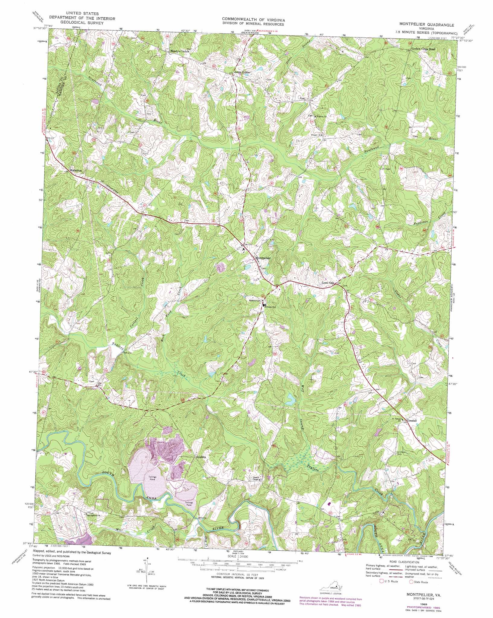
Montpelier Topo Map Virginia
To zoom in, hover over the map of Montpelier
USGS Topo Quad 37077g6 - 1:24,000 scale
| Topo Map Name: | Montpelier |
| USGS Topo Quad ID: | 37077g6 |
| Print Size: | ca. 21 1/4" wide x 27" high |
| Southeast Coordinates: | 37.75° N latitude / 77.625° W longitude |
| Map Center Coordinates: | 37.8125° N latitude / 77.6875° W longitude |
| U.S. State: | VA |
| Filename: | o37077g6.jpg |
| Download Map JPG Image: | Montpelier topo map 1:24,000 scale |
| Map Type: | Topographic |
| Topo Series: | 7.5´ |
| Map Scale: | 1:24,000 |
| Source of Map Images: | United States Geological Survey (USGS) |
| Alternate Map Versions: |
Mabelton VA 1943, updated 1961 Download PDF Buy paper map Montpelier VA 1969, updated 1971 Download PDF Buy paper map Montpelier VA 1969, updated 1981 Download PDF Buy paper map Montpelier VA 1969, updated 1985 Download PDF Buy paper map Montpelier VA 2010 Download PDF Buy paper map Montpelier VA 2013 Download PDF Buy paper map Montpelier VA 2016 Download PDF Buy paper map |
1:24,000 Topo Quads surrounding Montpelier
Mineral |
Lake Anna West |
Lake Anna East |
Ladysmith |
Woodford |
Pendleton |
Buckner |
Beaverdam |
Hewlett |
Ruther Glen |
South Anna |
Dabneys |
Montpelier |
Hanover Academy |
Ashland |
Goochland |
Perkinsville |
Hylas |
Glen Allen |
Yellow Tavern |
Powhatan |
Fine Creek Mills |
Midlothian |
Bon Air |
Richmond |
> Back to 37077e1 at 1:100,000 scale
> Back to 37076a1 at 1:250,000 scale
> Back to U.S. Topo Maps home
Montpelier topo map: Gazetteer
Montpelier: Dams
South Anna Number 52b Dam elevation 61m 200′Stone Dam elevation 71m 232′
The Feldspar Corporation Dam Number One elevation 64m 209′
The Feldspar Corporation Dam Number Two elevation 58m 190′
Montpelier: Populated Places
Goodall elevation 85m 278′Goshen Cross Road elevation 82m 269′
Gouldin elevation 85m 278′
Jones Corner elevation 95m 311′
Lone Oak elevation 103m 337′
Mabelton elevation 109m 357′
Montpelier elevation 102m 334′
Moodys Corner elevation 106m 347′
Montpelier: Reservoirs
Springfield Lake elevation 61m 200′Montpelier: Streams
Cattail Creek elevation 65m 213′Mill Creek elevation 54m 177′
Rock Ford Creek elevation 62m 203′
Shop Creek elevation 54m 177′
Taylors Creek elevation 46m 150′
Wolf Swamp elevation 58m 190′
Montpelier digital topo map on disk
Buy this Montpelier topo map showing relief, roads, GPS coordinates and other geographical features, as a high-resolution digital map file on DVD:
Atlantic Coast (NY, NJ, PA, DE, MD, VA, NC)
Buy digital topo maps: Atlantic Coast (NY, NJ, PA, DE, MD, VA, NC)
 map DVD")