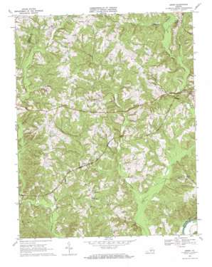
Aspen Topo Map Virginia
To zoom in, hover over the map of Aspen
USGS Topo Quad 37078a7 - 1:24,000 scale
| Topo Map Name: | Aspen |
| USGS Topo Quad ID: | 37078a7 |
| Print Size: | ca. 21 1/4" wide x 27" high |
| Southeast Coordinates: | 37° N latitude / 78.75° W longitude |
| Map Center Coordinates: | 37.0625° N latitude / 78.8125° W longitude |
| U.S. State: | VA |
| Filename: | o37078a7.jpg |
| Download Map JPG Image: | Aspen topo map 1:24,000 scale |
| Map Type: | Topographic |
| Topo Series: | 7.5´ |
| Map Scale: | 1:24,000 |
| Source of Map Images: | United States Geological Survey (USGS) |
| Alternate Map Versions: |
Aspen VA 1968, updated 1971 Download PDF Buy paper map Aspen VA 2010 Download PDF Buy paper map Aspen VA 2013 Download PDF Buy paper map Aspen VA 2016 Download PDF Buy paper map |
1:24,000 Topo Quads surrounding Aspen
> Back to 37078a1 at 1:100,000 scale
> Back to 37078a1 at 1:250,000 scale
> Back to U.S. Topo Maps home
Aspen topo map: Gazetteer
Aspen: Populated Places
Abell (historical) elevation 189m 620′Aspen elevation 141m 462′
Aspenwall elevation 162m 531′
Baileyville (historical) elevation 200m 656′
Rough Creek elevation 149m 488′
Wren elevation 184m 603′
Aspen: Streams
Buck Branch elevation 112m 367′Double Branch elevation 146m 479′
Little Louse Creek elevation 109m 357′
Louse Creek elevation 103m 337′
Rough Creek elevation 116m 380′
Temple Branch elevation 113m 370′
Turkey Branch elevation 118m 387′
Aspen digital topo map on disk
Buy this Aspen topo map showing relief, roads, GPS coordinates and other geographical features, as a high-resolution digital map file on DVD:
Western Virginia & Southern West Virginia
Buy digital topo maps: Western Virginia & Southern West Virginia


