Mike Topo Map Virginia
To zoom in, hover over the map of Mike
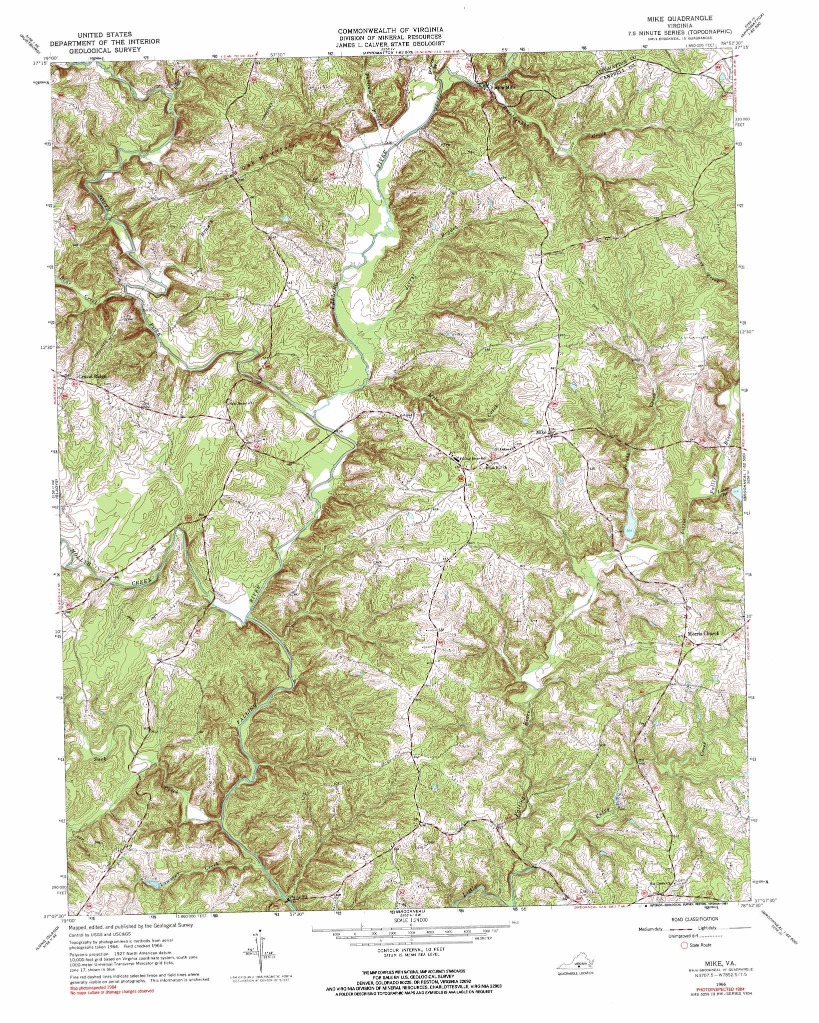
USGS Topo Quad 37078b8 - 1:24,000 scale
| Topo Map Name: | Mike |
| USGS Topo Quad ID: | 37078b8 |
| Print Size: | ca. 21 1/4" wide x 27" high |
| Southeast Coordinates: | 37.125° N latitude / 78.875° W longitude |
| Map Center Coordinates: | 37.1875° N latitude / 78.9375° W longitude |
| U.S. State: | VA |
| Filename: | o37078b8.jpg |
| Download Map JPG Image: | Mike topo map 1:24,000 scale |
| Map Type: | Topographic |
| Topo Series: | 7.5´ |
| Map Scale: | 1:24,000 |
| Source of Map Images: | United States Geological Survey (USGS) |
| Alternate Map Versions: |
Mike VA 1966, updated 1968 Download PDF Buy paper map Mike VA 1966, updated 1991 Download PDF Buy paper map Mike VA 2010 Download PDF Buy paper map Mike VA 2013 Download PDF Buy paper map Mike VA 2016 Download PDF Buy paper map |
1:24,000 Topo Quads surrounding Mike
Lynchburg |
Kelly |
Stonewall |
Vera |
Holiday Lake |
City Farm |
Rustburg |
Concord |
Appomattox |
Pamplin |
Castle Craig |
Gladys |
Mike |
Red House |
Madisonville |
Straightstone |
Long Island |
Brookneal |
Aspen |
Charlotte Court House |
Mount Airy |
Republican Grove |
Nathalie |
Conner Lake |
Saxe |
> Back to 37078a1 at 1:100,000 scale
> Back to 37078a1 at 1:250,000 scale
> Back to U.S. Topo Maps home
Mike topo map: Gazetteer
Mike: Dams
Jones Dam elevation 207m 679′Little Falling River Number Three Dam elevation 162m 531′
Little Falling River Number Two Dam elevation 166m 544′
Mike: Populated Places
Spring Mills elevation 158m 518′Mike: Reservoirs
Jones Pond elevation 207m 679′Mike: Streams
Bargers Branch elevation 149m 488′Bear Creek elevation 158m 518′
Bull Branch elevation 164m 538′
Entry Creek elevation 133m 436′
Jacobs Creek elevation 149m 488′
Jerrys Branch elevation 139m 456′
Lawsons Creek elevation 128m 419′
Long Branch elevation 152m 498′
Lucks Branch elevation 154m 505′
Mill Creek elevation 143m 469′
Mollys Creek elevation 134m 439′
Pulliam Branch elevation 146m 479′
Rattlesnake Creek elevation 156m 511′
South Fork Falling River elevation 137m 449′
Suck Creek elevation 128m 419′
Mike: Summits
Red Oak Mountain elevation 232m 761′Mike digital topo map on disk
Buy this Mike topo map showing relief, roads, GPS coordinates and other geographical features, as a high-resolution digital map file on DVD:
Western Virginia & Southern West Virginia
Buy digital topo maps: Western Virginia & Southern West Virginia