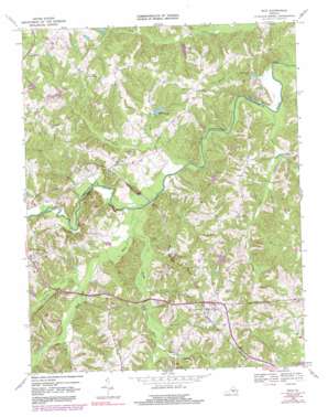
Rice Topo Map Virginia
To zoom in, hover over the map of Rice
USGS Topo Quad 37078c3 - 1:24,000 scale
| Topo Map Name: | Rice |
| USGS Topo Quad ID: | 37078c3 |
| Print Size: | ca. 21 1/4" wide x 27" high |
| Southeast Coordinates: | 37.25° N latitude / 78.25° W longitude |
| Map Center Coordinates: | 37.3125° N latitude / 78.3125° W longitude |
| U.S. State: | VA |
| Filename: | o37078c3.jpg |
| Download Map JPG Image: | Rice topo map 1:24,000 scale |
| Map Type: | Topographic |
| Topo Series: | 7.5´ |
| Map Scale: | 1:24,000 |
| Source of Map Images: | United States Geological Survey (USGS) |
| Alternate Map Versions: |
Rice VA 1968, updated 1971 Download PDF Buy paper map Rice VA 1968, updated 1975 Download PDF Buy paper map Rice VA 1968, updated 1982 Download PDF Buy paper map Rice VA 1968, updated 1991 Download PDF Buy paper map Rice VA 2010 Download PDF Buy paper map Rice VA 2013 Download PDF Buy paper map Rice VA 2016 Download PDF Buy paper map |
1:24,000 Topo Quads surrounding Rice
> Back to 37078a1 at 1:100,000 scale
> Back to 37078a1 at 1:250,000 scale
> Back to U.S. Topo Maps home
Rice topo map: Gazetteer
Rice: Bridges
High Bridge elevation 86m 282′Jamestown Bridge (historical) elevation 81m 265′
Rice: Crossings
Mortons Ford elevation 79m 259′Rice: Dams
Ancel Dam elevation 94m 308′Frost Dam elevation 88m 288′
Hines Dam elevation 155m 508′
Ingle Dam elevation 112m 367′
Lafoon, Watkins and Perry Dam elevation 121m 396′
Lancaster Dam elevation 116m 380′
Millwood Pond Dam elevation 101m 331′
Watson Dam elevation 90m 295′
Wilck Dam elevation 131m 429′
Wilsons Dam elevation 99m 324′
Wilsons Dam elevation 123m 403′
Rice: Populated Places
Jamestown (historical) elevation 82m 269′Raines Tavern elevation 145m 475′
Rice elevation 139m 456′
Stoddert elevation 132m 433′
Rice: Reservoirs
Ancel Pond elevation 94m 308′Hines Pond elevation 155m 508′
Ingle Lake elevation 112m 367′
Millwood Pond elevation 101m 331′
Wilson Lake elevation 99m 324′
Wilsons Pond elevation 123m 403′
Wilsons Pond elevation 96m 314′
Rice: Streams
Bacon Branch elevation 91m 298′Bad Luck Branch elevation 85m 278′
Briery Creek elevation 88m 288′
Broad Branch elevation 79m 259′
Brown Branch elevation 86m 282′
Bush River elevation 84m 275′
Green Creek elevation 84m 275′
Little Saylers Creek elevation 84m 275′
Marrowbone Creek elevation 93m 305′
Marshall Branch elevation 91m 298′
Millers Creek elevation 92m 301′
Sandy River elevation 85m 278′
Saylers Creek elevation 79m 259′
Rice digital topo map on disk
Buy this Rice topo map showing relief, roads, GPS coordinates and other geographical features, as a high-resolution digital map file on DVD:
Western Virginia & Southern West Virginia
Buy digital topo maps: Western Virginia & Southern West Virginia


