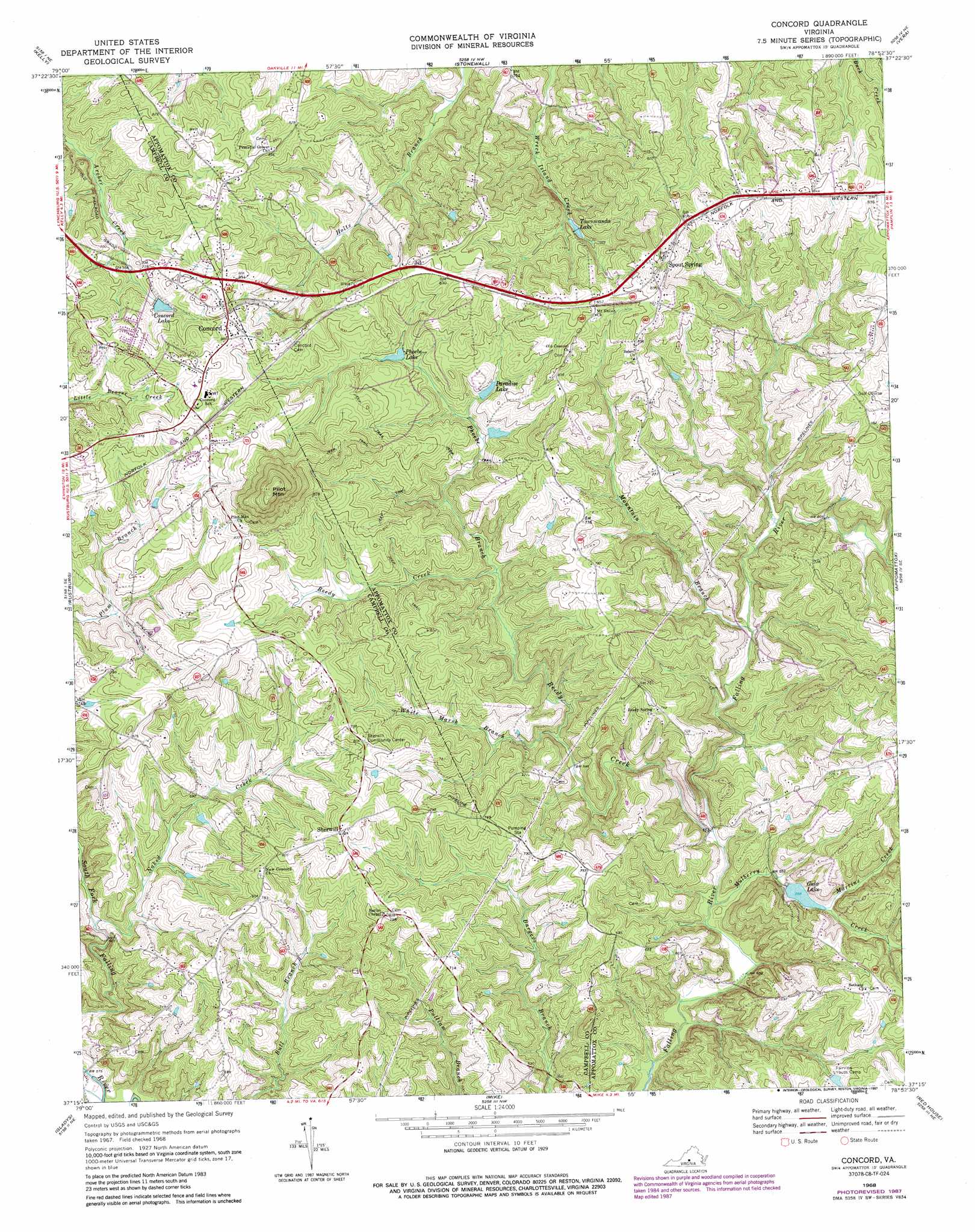
Concord Topo Map Virginia
To zoom in, hover over the map of Concord
USGS Topo Quad 37078c8 - 1:24,000 scale
| Topo Map Name: | Concord |
| USGS Topo Quad ID: | 37078c8 |
| Print Size: | ca. 21 1/4" wide x 27" high |
| Southeast Coordinates: | 37.25° N latitude / 78.875° W longitude |
| Map Center Coordinates: | 37.3125° N latitude / 78.9375° W longitude |
| U.S. State: | VA |
| Filename: | o37078c8.jpg |
| Download Map JPG Image: | Concord topo map 1:24,000 scale |
| Map Type: | Topographic |
| Topo Series: | 7.5´ |
| Map Scale: | 1:24,000 |
| Source of Map Images: | United States Geological Survey (USGS) |
| Alternate Map Versions: |
Concord VA 1968, updated 1971 Download PDF Buy paper map Concord VA 1968, updated 1987 Download PDF Buy paper map Concord VA 2010 Download PDF Buy paper map Concord VA 2013 Download PDF Buy paper map Concord VA 2016 Download PDF Buy paper map |
1:24,000 Topo Quads surrounding Concord
Tobacco Row Mountain |
Amherst |
Buffalo Ridge |
Gladstone |
Saint Joy |
Lynchburg |
Kelly |
Stonewall |
Vera |
Holiday Lake |
City Farm |
Rustburg |
Concord |
Appomattox |
Pamplin |
Castle Craig |
Gladys |
Mike |
Red House |
Madisonville |
Straightstone |
Long Island |
Brookneal |
Aspen |
Charlotte Court House |
> Back to 37078a1 at 1:100,000 scale
> Back to 37078a1 at 1:250,000 scale
> Back to U.S. Topo Maps home
Concord topo map: Gazetteer
Concord: Dams
East Fork Falling River Number Seven Dam elevation 177m 580′Fairview Youth Camp Dam elevation 194m 636′
Moody Dam elevation 242m 793′
Concord: Populated Places
Concord elevation 269m 882′Old Pilot (historical) elevation 235m 770′
Sherwill elevation 251m 823′
Spout Spring elevation 268m 879′
Concord: Reservoirs
Concord Lake elevation 242m 793′Gala Lake elevation 173m 567′
Paradise Lake elevation 220m 721′
Phoebe Lake elevation 225m 738′
Townwanda Lake elevation 222m 728′
Concord: Streams
Martins Creek elevation 174m 570′Mountain Branch elevation 174m 570′
Mulberry Creek elevation 161m 528′
Naked Creek elevation 179m 587′
Phoebe Branch elevation 194m 636′
Reedy Creek elevation 163m 534′
White Marsh Branch elevation 181m 593′
Concord: Summits
Pilot Mountain elevation 347m 1138′Concord digital topo map on disk
Buy this Concord topo map showing relief, roads, GPS coordinates and other geographical features, as a high-resolution digital map file on DVD:
Western Virginia & Southern West Virginia
Buy digital topo maps: Western Virginia & Southern West Virginia