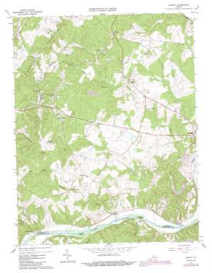
Esmont Topo Map Virginia
To zoom in, hover over the map of Esmont
USGS Topo Quad 37078g5 - 1:24,000 scale
| Topo Map Name: | Esmont |
| USGS Topo Quad ID: | 37078g5 |
| Print Size: | ca. 21 1/4" wide x 27" high |
| Southeast Coordinates: | 37.75° N latitude / 78.5° W longitude |
| Map Center Coordinates: | 37.8125° N latitude / 78.5625° W longitude |
| U.S. State: | VA |
| Filename: | o37078g5.jpg |
| Download Map JPG Image: | Esmont topo map 1:24,000 scale |
| Map Type: | Topographic |
| Topo Series: | 7.5´ |
| Map Scale: | 1:24,000 |
| Source of Map Images: | United States Geological Survey (USGS) |
| Alternate Map Versions: |
Esmont VA 1967, updated 1968 Download PDF Buy paper map Esmont VA 1967, updated 1977 Download PDF Buy paper map Esmont VA 1967, updated 1987 Download PDF Buy paper map Esmont VA 1979, updated 1982 Download PDF Buy paper map Esmont VA 2010 Download PDF Buy paper map Esmont VA 2013 Download PDF Buy paper map Esmont VA 2016 Download PDF Buy paper map |
1:24,000 Topo Quads surrounding Esmont
> Back to 37078e1 at 1:100,000 scale
> Back to 37078a1 at 1:250,000 scale
> Back to U.S. Topo Maps home
Esmont topo map: Gazetteer
Esmont: Crossings
Hattons Ferry elevation 82m 269′Esmont: Dams
Allmans Dam elevation 115m 377′Delutz Dam elevation 127m 416′
Stillfreds Dam elevation 111m 364′
Stillfried Dam elevation 129m 423′
Totier Creek Dam elevation 87m 285′
Vanclieffs Dam elevation 147m 482′
Esmont: Islands
Goosby Island elevation 89m 291′Rock Island elevation 118m 387′
Esmont: Parks
Scottsville Recreation Center elevation 119m 390′Totier Creek Reservoir Park elevation 110m 360′
Esmont: Populated Places
Boiling Spring elevation 106m 347′Brownton (historical) elevation 150m 492′
Browntown elevation 153m 501′
Esmont elevation 138m 452′
Glendower elevation 118m 387′
Hatton elevation 87m 285′
Keene elevation 167m 547′
McCullough elevation 93m 305′
Porters elevation 172m 564′
Tapscott elevation 130m 426′
Totier Hills elevation 125m 410′
Valmont Estates elevation 122m 400′
Warren elevation 92m 301′
Esmont: Post Offices
Esmont Post Office elevation 136m 446′Keene Post Office elevation 172m 564′
Esmont: Reservoirs
Allmans Pond elevation 115m 377′Delutz Pond elevation 127m 416′
Stillfreds Pond elevation 111m 364′
Stillfried Pond elevation 129m 423′
Totier Creek Reservoir elevation 87m 285′
Vanclieffs Lake elevation 147m 482′
Esmont: Streams
Ballinger Creek elevation 84m 275′Brokenborough Creek elevation 87m 285′
Fallsburg Creek elevation 85m 278′
Joe Creek elevation 111m 364′
Mill Creek elevation 87m 285′
Miller Creek elevation 90m 295′
Ramsey Creek elevation 88m 288′
Rock Castle Creek elevation 87m 285′
Rock Island Creek elevation 84m 275′
Wolftrap Branch elevation 117m 383′
Esmont: Summits
Green Mountain elevation 196m 643′Esmont digital topo map on disk
Buy this Esmont topo map showing relief, roads, GPS coordinates and other geographical features, as a high-resolution digital map file on DVD:
Western Virginia & Southern West Virginia
Buy digital topo maps: Western Virginia & Southern West Virginia


