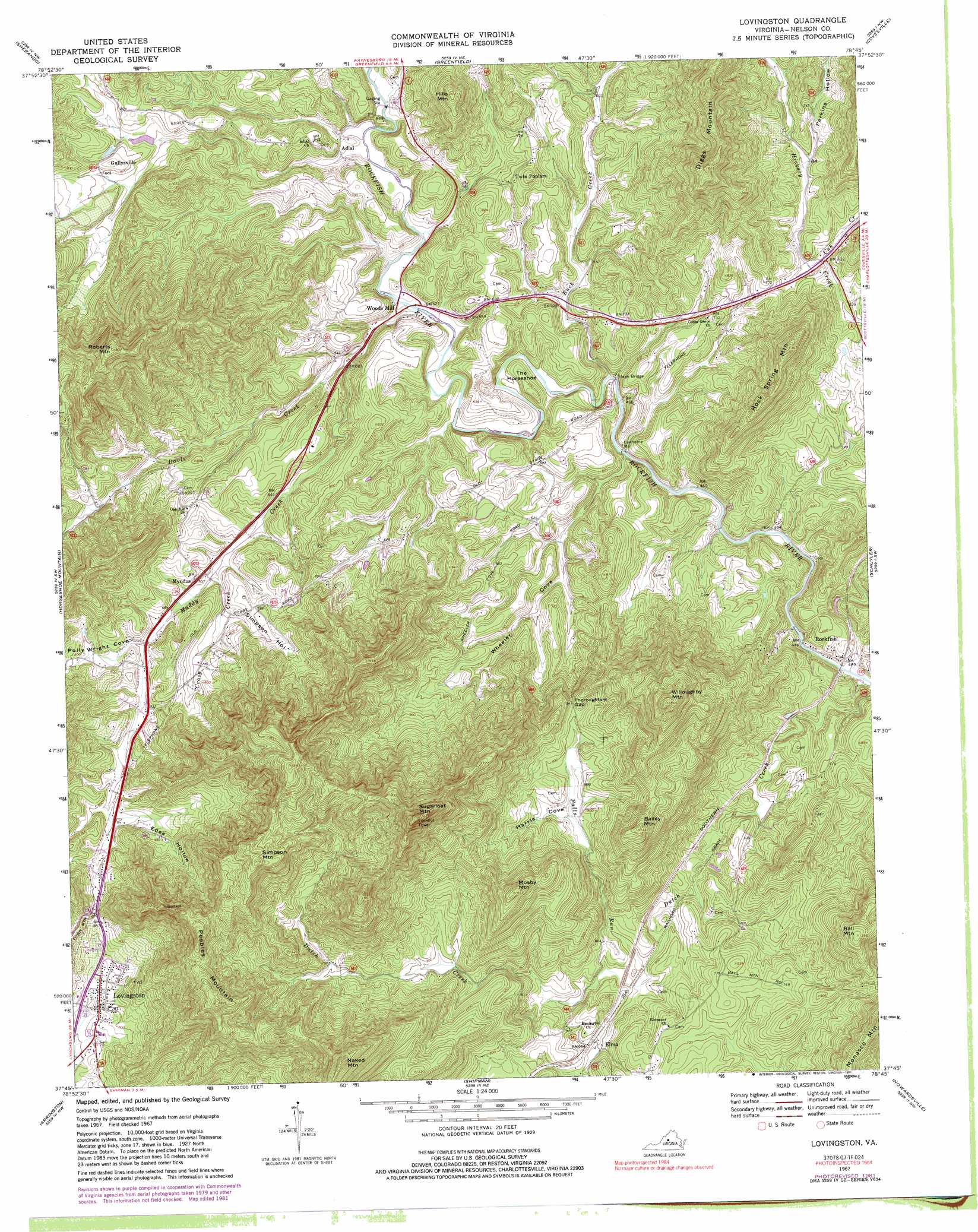
Lovingston Topo Map Virginia
To zoom in, hover over the map of Lovingston
USGS Topo Quad 37078g7 - 1:24,000 scale
| Topo Map Name: | Lovingston |
| USGS Topo Quad ID: | 37078g7 |
| Print Size: | ca. 21 1/4" wide x 27" high |
| Southeast Coordinates: | 37.75° N latitude / 78.75° W longitude |
| Map Center Coordinates: | 37.8125° N latitude / 78.8125° W longitude |
| U.S. State: | VA |
| Filename: | o37078g7.jpg |
| Download Map JPG Image: | Lovingston topo map 1:24,000 scale |
| Map Type: | Topographic |
| Topo Series: | 7.5´ |
| Map Scale: | 1:24,000 |
| Source of Map Images: | United States Geological Survey (USGS) |
| Alternate Map Versions: |
Lovingston VA 1967, updated 1970 Download PDF Buy paper map Lovingston VA 1967, updated 1977 Download PDF Buy paper map Lovingston VA 1967, updated 1981 Download PDF Buy paper map Lovingston VA 1967, updated 1991 Download PDF Buy paper map Lovingston VA 1967, updated 1991 Download PDF Buy paper map Lovingston VA 2010 Download PDF Buy paper map Lovingston VA 2013 Download PDF Buy paper map Lovingston VA 2016 Download PDF Buy paper map |
1:24,000 Topo Quads surrounding Lovingston
Stuarts Draft |
Waynesboro West |
Waynesboro East |
Crozet |
Charlottesville West |
Big Levels |
Sherando |
Greenfield |
Covesville |
Alberene |
Massies Mill |
Horseshoe Mountain |
Lovingston |
Schuyler |
Esmont |
Piney River |
Arrington |
Shipman |
Howardsville |
Glenmore |
Amherst |
Buffalo Ridge |
Gladstone |
Saint Joy |
Buckingham |
> Back to 37078e1 at 1:100,000 scale
> Back to 37078a1 at 1:250,000 scale
> Back to U.S. Topo Maps home
Lovingston topo map: Gazetteer
Lovingston: Bridges
Stage Bridge elevation 145m 475′Lovingston: Dams
Bernard Hamilton Dam elevation 228m 748′Lovingston: Gaps
Thoroughfare Gap elevation 286m 938′Lovingston: Populated Places
Adial elevation 170m 557′Elma elevation 197m 646′
Gullysville elevation 240m 787′
Lawthorne Mill elevation 150m 492′
Lovingston elevation 227m 744′
Old Myndus elevation 238m 780′
Rockfish elevation 143m 469′
Twin Poplars elevation 214m 702′
Woods Mill elevation 161m 528′
Lovingston: Reservoirs
Hamilton Lake elevation 228m 748′Lovingston: Streams
Buck Creek elevation 143m 469′Cove Creek elevation 131m 429′
Craig Creek elevation 200m 656′
Cub Creek elevation 190m 623′
Davis Creek elevation 156m 511′
Muddy Creek elevation 164m 538′
Lovingston: Summits
Bailey Mountain elevation 437m 1433′Ball Mountain elevation 419m 1374′
Diggs Mountain elevation 488m 1601′
Hills Mountain elevation 368m 1207′
Mosby Mountain elevation 473m 1551′
Naked Mountain elevation 607m 1991′
Peebles Mountain elevation 556m 1824′
Roberts Mountain elevation 544m 1784′
Rock Spring Mountain elevation 416m 1364′
Simpson Mountain elevation 570m 1870′
Sugarloaf Mountain elevation 677m 2221′
The Horseshoe elevation 171m 561′
Willoughby Mountain elevation 562m 1843′
Lovingston: Valleys
Edes Hollow elevation 242m 793′Harris Cove elevation 254m 833′
Melton Hollow elevation 257m 843′
Perkins Hollow elevation 206m 675′
Polly Wright Cove elevation 212m 695′
Simpson Hollow elevation 214m 702′
Wheeler Cove elevation 167m 547′
Lovingston digital topo map on disk
Buy this Lovingston topo map showing relief, roads, GPS coordinates and other geographical features, as a high-resolution digital map file on DVD:
Western Virginia & Southern West Virginia
Buy digital topo maps: Western Virginia & Southern West Virginia