Sherando Topo Map Virginia
To zoom in, hover over the map of Sherando
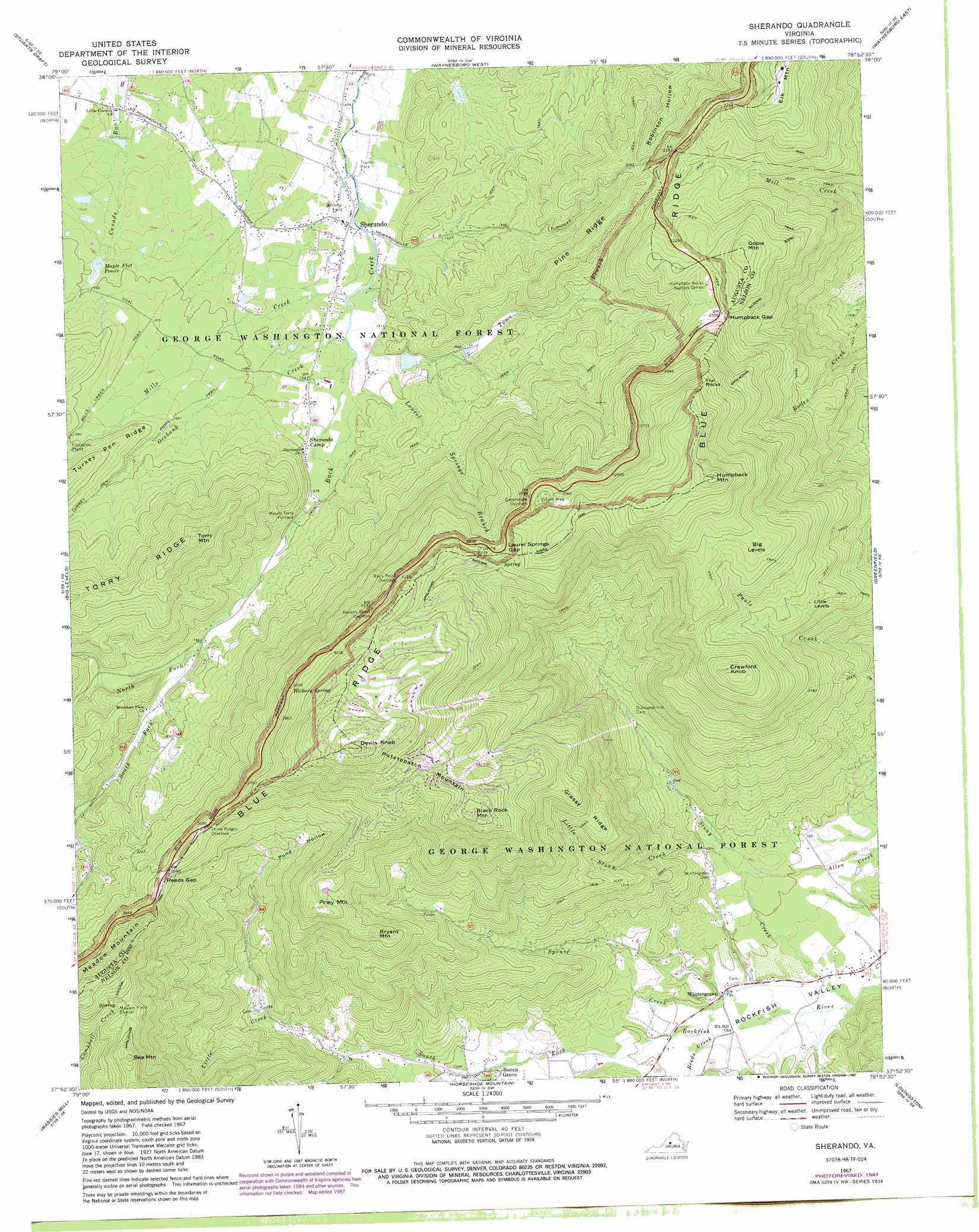
USGS Topo Quad 37078h8 - 1:24,000 scale
| Topo Map Name: | Sherando |
| USGS Topo Quad ID: | 37078h8 |
| Print Size: | ca. 21 1/4" wide x 27" high |
| Southeast Coordinates: | 37.875° N latitude / 78.875° W longitude |
| Map Center Coordinates: | 37.9375° N latitude / 78.9375° W longitude |
| U.S. State: | VA |
| Filename: | o37078h8.jpg |
| Download Map JPG Image: | Sherando topo map 1:24,000 scale |
| Map Type: | Topographic |
| Topo Series: | 7.5´ |
| Map Scale: | 1:24,000 |
| Source of Map Images: | United States Geological Survey (USGS) |
| Alternate Map Versions: |
Sherando VA 1967, updated 1970 Download PDF Buy paper map Sherando VA 1967, updated 1970 Download PDF Buy paper map Sherando VA 1967, updated 1981 Download PDF Buy paper map Sherando VA 1967, updated 1987 Download PDF Buy paper map Sherando VA 2011 Download PDF Buy paper map Sherando VA 2013 Download PDF Buy paper map Sherando VA 2016 Download PDF Buy paper map |
| FStopo: | US Forest Service topo Sherando is available: Download FStopo PDF Download FStopo TIF |
1:24,000 Topo Quads surrounding Sherando
Churchville |
Staunton |
Fort Defiance |
Crimora |
Browns Cove |
Greenville |
Stuarts Draft |
Waynesboro West |
Waynesboro East |
Crozet |
Vesuvius |
Big Levels |
Sherando |
Greenfield |
Covesville |
Montebello |
Massies Mill |
Horseshoe Mountain |
Lovingston |
Schuyler |
Forks Of Buffalo |
Piney River |
Arrington |
Shipman |
Howardsville |
> Back to 37078e1 at 1:100,000 scale
> Back to 37078a1 at 1:250,000 scale
> Back to U.S. Topo Maps home
Sherando topo map: Gazetteer
Sherando: Airports
Rockfish Airpark elevation 226m 741′Sherando: Dams
South River Number 11 Dam elevation 449m 1473′South River Number 24 Dam elevation 448m 1469′
South River Number 25 Dam elevation 471m 1545′
Sherando: Flats
Big Levels elevation 900m 2952′Little Levels elevation 700m 2296′
Sherando: Gaps
Humpback Gap elevation 723m 2372′Laurel Springs Gap elevation 882m 2893′
Reids Gap elevation 807m 2647′
Sherando: Populated Places
Beech Grove elevation 291m 954′Mount Torry Furnace elevation 485m 1591′
Sherando elevation 448m 1469′
Wintergreen elevation 230m 754′
Sherando: Reservoirs
Falling Rocks Lake elevation 471m 1545′Happy Hollow Lake elevation 448m 1469′
Lake Wilda elevation 449m 1473′
Maple Flat Ponds elevation 475m 1558′
Sherando: Ridges
Grassy Ridge elevation 718m 2355′Pine Ridge elevation 631m 2070′
Turkey Pen Ridge elevation 648m 2125′
Sherando: Springs
Hickory Spring elevation 903m 2962′Sherando: Streams
Laurel Springs Branch elevation 461m 1512′Little Creek elevation 384m 1259′
Little Stony Creek elevation 279m 915′
Mills Creek elevation 448m 1469′
North Fork Back Creek elevation 511m 1676′
Orebank Creek elevation 460m 1509′
Reids Creek elevation 230m 754′
South Fork Back Creek elevation 511m 1676′
Spruce Creek elevation 214m 702′
Stony Creek elevation 206m 675′
Toms Branch elevation 472m 1548′
Sherando: Summits
Bee Mountain elevation 921m 3021′Black Rock Mountain elevation 1050m 3444′
Bryant Mountain elevation 775m 2542′
Crawford Knob elevation 918m 3011′
Devils Knob elevation 1172m 3845′
Dobie Mountain elevation 820m 2690′
Dripping Rock elevation 913m 2995′
Humpback Mountain elevation 1099m 3605′
Meadow Mountain elevation 950m 3116′
Piney Mountain elevation 846m 2775′
PJs Mound elevation 677m 2221′
Potatopatch Mountain elevation 1172m 3845′
The Rocks elevation 949m 3113′
Torry Mountain elevation 843m 2765′
Sherando: Trails
Turkey Pen Ridge Trail elevation 546m 1791′Sherando: Valleys
Pond Hollow elevation 538m 1765′Sherando digital topo map on disk
Buy this Sherando topo map showing relief, roads, GPS coordinates and other geographical features, as a high-resolution digital map file on DVD:
Western Virginia & Southern West Virginia
Buy digital topo maps: Western Virginia & Southern West Virginia