Smith Mountain Dam Topo Map Virginia
To zoom in, hover over the map of Smith Mountain Dam
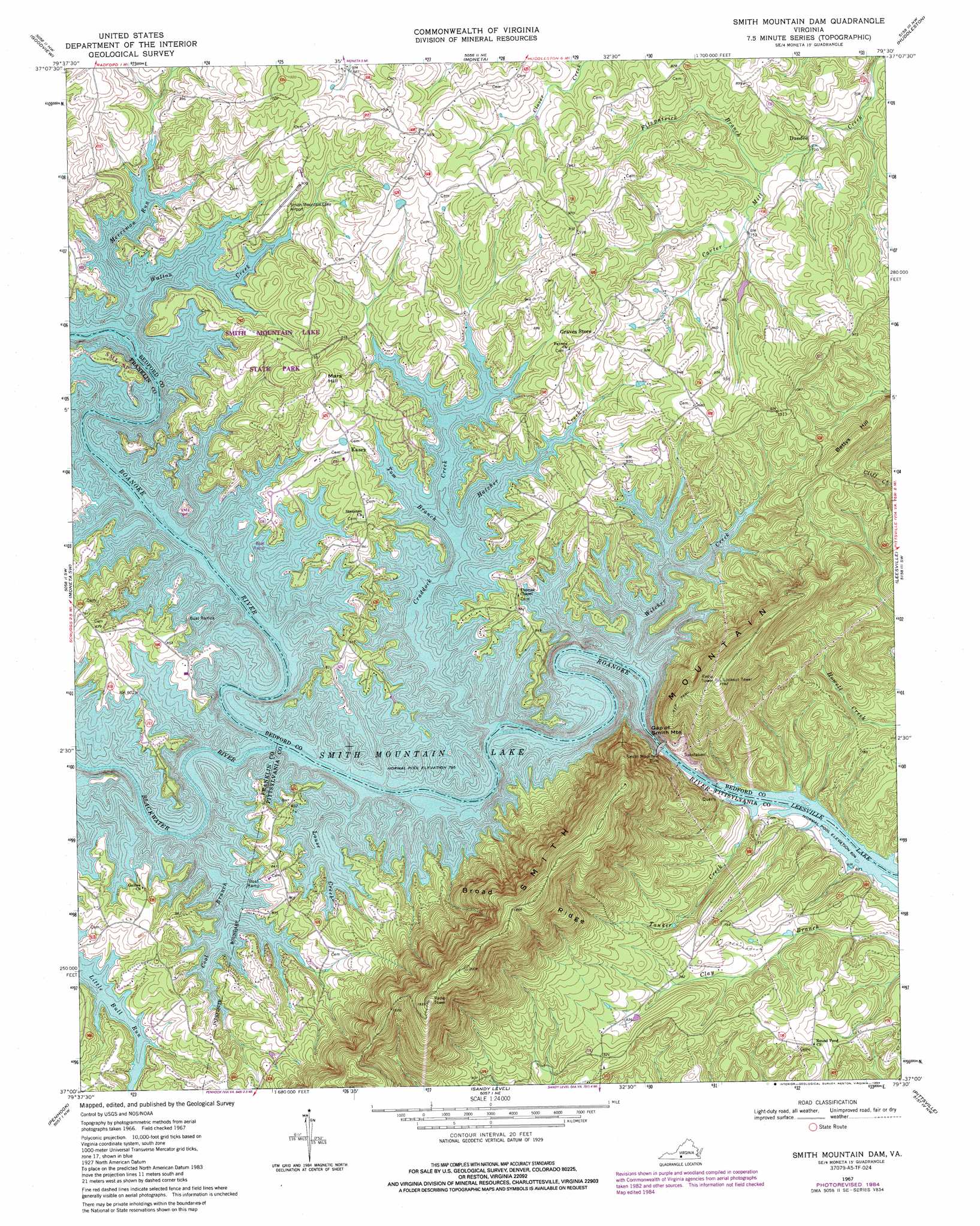
USGS Topo Quad 37079a5 - 1:24,000 scale
| Topo Map Name: | Smith Mountain Dam |
| USGS Topo Quad ID: | 37079a5 |
| Print Size: | ca. 21 1/4" wide x 27" high |
| Southeast Coordinates: | 37° N latitude / 79.5° W longitude |
| Map Center Coordinates: | 37.0625° N latitude / 79.5625° W longitude |
| U.S. State: | VA |
| Filename: | o37079a5.jpg |
| Download Map JPG Image: | Smith Mountain Dam topo map 1:24,000 scale |
| Map Type: | Topographic |
| Topo Series: | 7.5´ |
| Map Scale: | 1:24,000 |
| Source of Map Images: | United States Geological Survey (USGS) |
| Alternate Map Versions: |
Smith Mountain Dam VA 1967, updated 1969 Download PDF Buy paper map Smith Mountain Dam VA 1967, updated 1984 Download PDF Buy paper map Smith Mountain Dam VA 1967, updated 1984 Download PDF Buy paper map Smith Mountain Dam VA 1977, updated 1983 Download PDF Buy paper map Smith Mountain Dam VA 2012 Download PDF Buy paper map Smith Mountain Dam VA 2013 Download PDF Buy paper map Smith Mountain Dam VA 2016 Download PDF Buy paper map |
1:24,000 Topo Quads surrounding Smith Mountain Dam
Stewartsville |
Irving |
Bedford |
Goode |
Forest |
Hardy |
Goodview |
Moneta |
Huddleston |
Lynch Station |
Redwood |
Moneta Sw |
Smith Mountain Dam |
Leesville |
Altavista |
Gladehill |
Penhook |
Sandy Level |
Pittsville |
Gretna |
Snow Creek |
Mountain Valley |
Callands |
Chatham |
Spring Garden |
> Back to 37079a1 at 1:100,000 scale
> Back to 37078a1 at 1:250,000 scale
> Back to U.S. Topo Maps home
Smith Mountain Dam topo map: Gazetteer
Smith Mountain Dam: Airports
Lakeview Aerodrome elevation 305m 1000′Lockerman Seaplane Base elevation 242m 793′
Red Birds Airyard Airport elevation 271m 889′
Smith Mountain Lake Airport elevation 265m 869′
Smith Mountain Dam: Bends
Horseshoe Bend elevation 242m 793′Smith Mountain Dam: Bridges
Anthony Ford Bridge (historical) elevation 242m 793′Smith Mountain Dam: Crossings
Anthonys Ford elevation 242m 793′Deerwood Ford elevation 184m 603′
Shallow Ford elevation 242m 793′
Smith Mountain Dam: Dams
Smith Mountain Dam elevation 242m 793′Smith Mountain Dam elevation 184m 603′
Smith Mountain Dam: Gaps
Gap of Smith Mountain elevation 242m 793′Smith Mountain Dam: Parks
Smith Mountain Lake State Park elevation 258m 846′Smith Mountain Dam: Populated Places
Dundee elevation 228m 748′Eagles Roost elevation 250m 820′
Gross Point elevation 244m 800′
Kasey elevation 267m 875′
Lake Haven elevation 245m 803′
Otter View (historical) elevation 301m 987′
Smith Mountain Dam: Reservoirs
Smith Mountain Lake elevation 184m 603′Smith Mountain Dam: Ridges
Broad Ridge elevation 568m 1863′Smith Mountain Dam: Streams
Blackwater River elevation 242m 793′Cool Branch elevation 242m 793′
Craddock Creek elevation 242m 793′
Fitzpatrick Branch elevation 219m 718′
Hatcher Creek elevation 242m 793′
Louse Creek elevation 242m 793′
McField Branch elevation 242m 793′
Merriman Run elevation 242m 793′
Tanker Creek elevation 184m 603′
Tom Branch elevation 242m 793′
Walton Creek elevation 242m 793′
Witcher Creek elevation 242m 793′
Smith Mountain Dam: Summits
Bettys Hill elevation 353m 1158′Mars Hill elevation 307m 1007′
Smith Mountain elevation 590m 1935′
Smith Mountain Dam: Valleys
Broad Ridge Hollow elevation 242m 793′Smith Mountain Dam digital topo map on disk
Buy this Smith Mountain Dam topo map showing relief, roads, GPS coordinates and other geographical features, as a high-resolution digital map file on DVD:
Western Virginia & Southern West Virginia
Buy digital topo maps: Western Virginia & Southern West Virginia